Dataset of Resource and Environment Atlas for the Purpose of Supporting and Serving the Planning, Construction and Green Development of Guangzhou
-
摘要:
在对最新的水工环地质调查资料和成果进行梳理和总结的基础上,以粤港澳大湾区三极之一的广州市为重点,编制了地学专业综合图集−《支撑服务广州市规划建设与绿色发展资源环境图集》。《图集》收集和整理了国土资源大调查以来粤港澳湾区开展的环境地质调查、监测数据资料和研究成果等,经二次开发研究,以通俗易读或图或表的形式表示出来。《图集》整体分为序图、国土空间开发利用的地质适宜性评价、城市规划建设应关注的重大地质安全问题、产业发展可以充分利用的优势地质资源、生态环境保护需要重视的资源环境状况和基础地质条件类图件6大类,共53张图,并提出了助力大湾区绿色生态农业发展、清洁能源产业发展、用水安全、旅游产业发展和提升防灾减灾能力等五方面的地质建议,有效服务了广州国土空间规划与海绵城市建设。
Abstract:The Dataset of the Resource and Environment Atlas for the Purpose of Supporting and Serving the Planning, Construction and Green Development of Guangzhou (also referred to as the Atlas), a professional integrated atlas in geology, was prepared based on a collation and summary of the latest materials and results obtained from hydrogeological, engineering geological and environmental geological surveys. It focuses on the development of Guangzhou, one of the three poles of the Guangdong – Hong Kong – Macao Greater Bay Area. In the Atlas, it collected and collated environmental geological surveys, monitoring data and research results carried out in Guangdong, Hong Kong, Macau and Bay Area since the Land and Resources Survey.. Moreover, they were expressed in a more popular and legible means such as figures or forms based on secondary study and development. In general, the Atlas consists of 53 maps and 6 categories, i.e., introductory maps, maps on the assessment of the geological suitability for the development and utilization of national land space, maps on the major geological safety problems that ought to be noted in urban planning and construction, maps on the advantageous geological resources that ought to be fully utilized for industrial development, maps on the state of the resources and environment that ought to be focused on for ecological environmental protection and maps on the basic geological conditions. Furthermore, the Atlas also contains the geological recommendations to support the development of green ecological agriculture, the development of a clean energy industry, safe use of water, the development of a tourism industry and the enhancement of the abilities to prevent and reduce natural disasters in the Guangdong – Hongkong – Macao Greater Bay Area, effectively serving the planning of national land space and the building of sponge cities in Guangzhou.
-

-
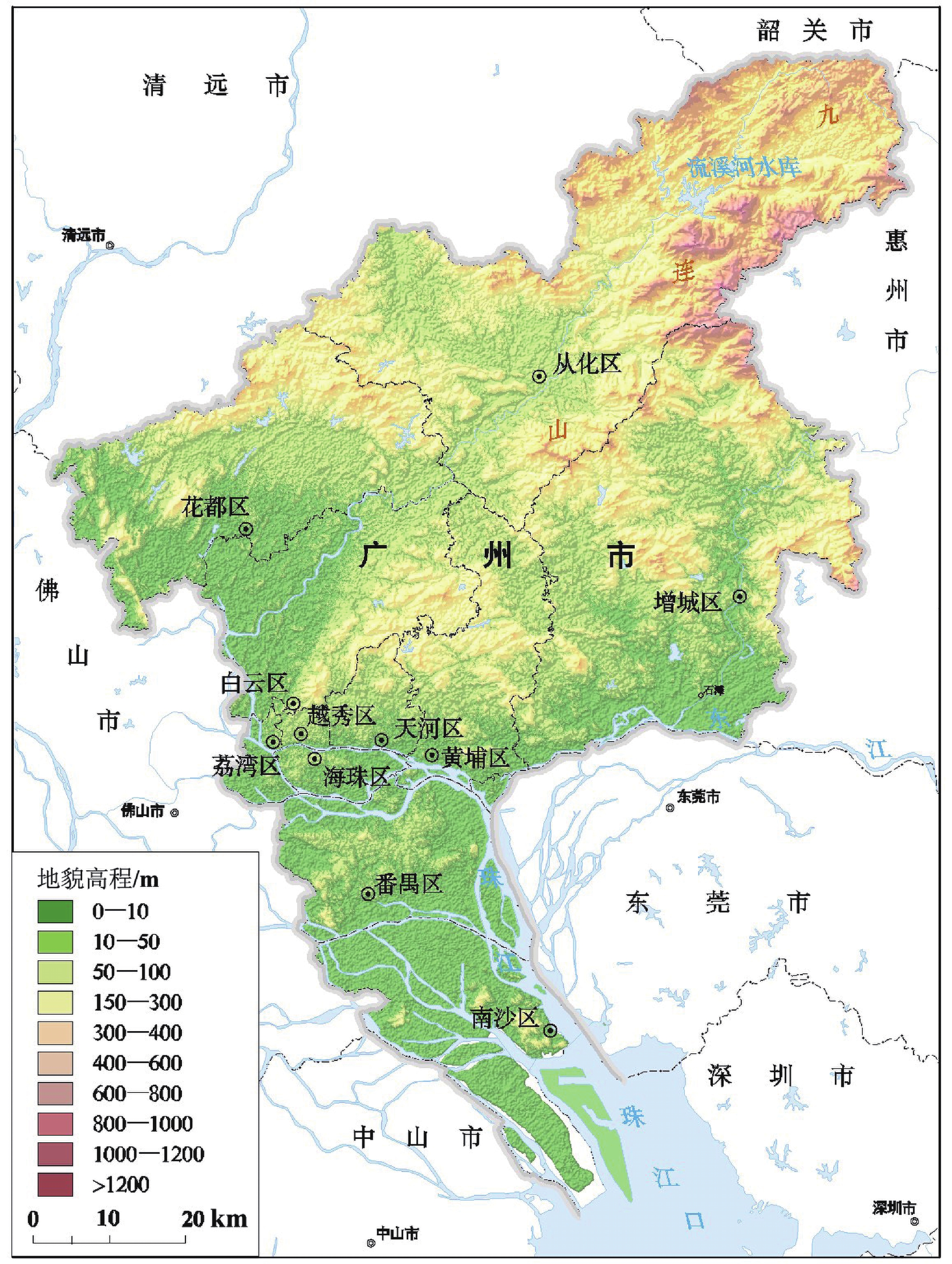
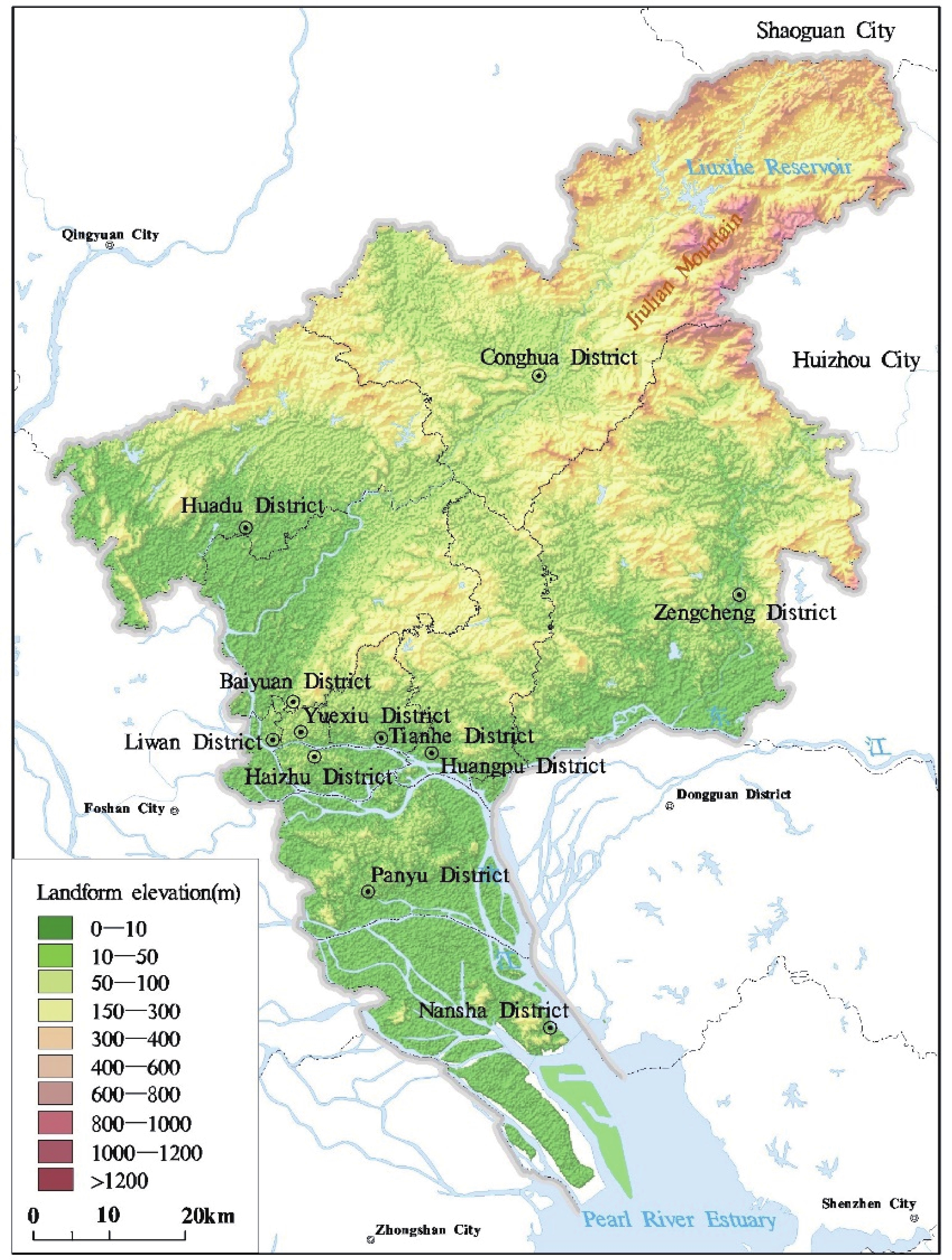
图 1 广州市三维地势图(自然资源部中国地质调查局,2019)
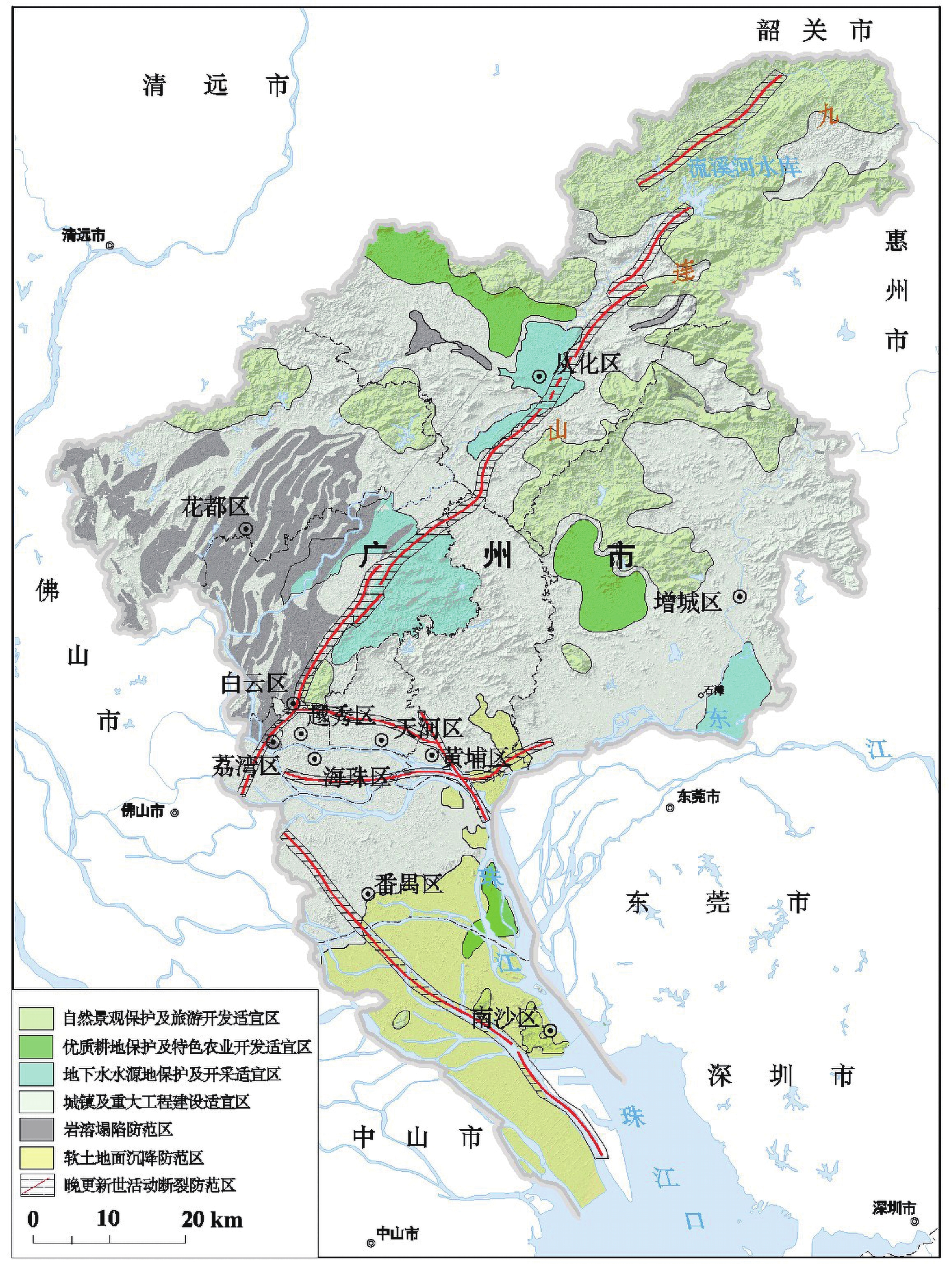
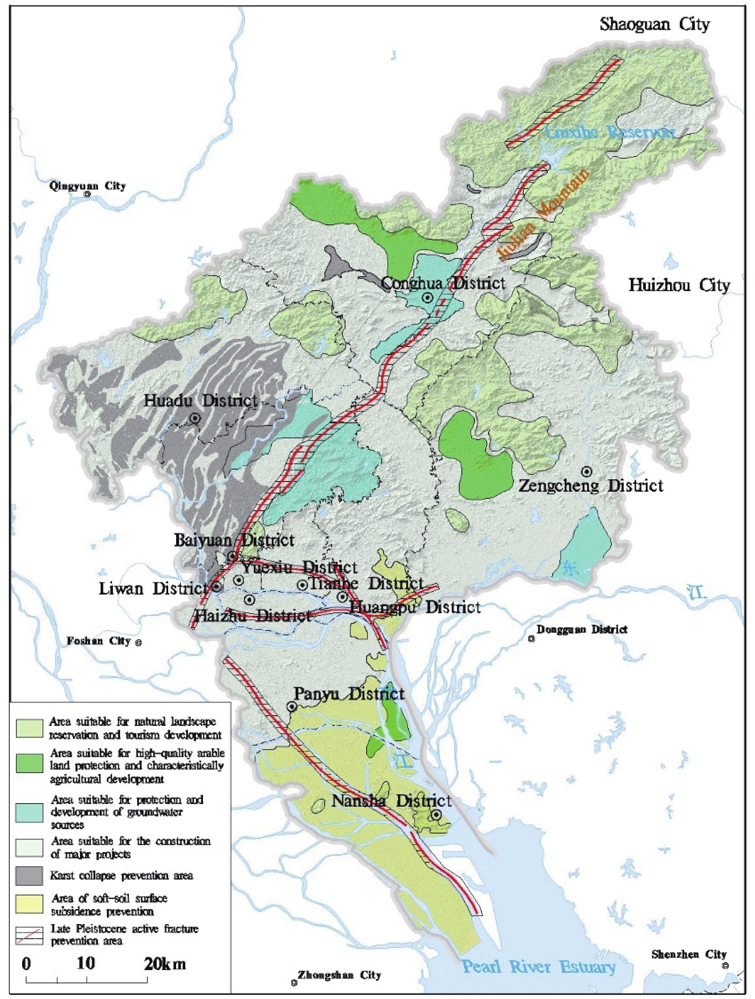
图 2 广州市国土空间开发利用管控建议图(自然资源部中国地质调查局,2019)
图 3 广州市优质富硒耕地资源保护及开发利用建议图(自然资源部中国地质调查局,2019)
表 1 数据库(集)元数据简表
条目 描述 数据库(集)名称 支撑服务广州市规划建设与绿色发展资源环境图集数据集 数据库(集)作者 刘凤梅,中国地质调查局武汉地质调查中心
黄长生,中国地质调查局武汉地质调查中心
郑小战,广州市地质调查院
赵信文,中国地质调查局武汉地质调查中心数据时间范围 2016年1月—2018年3月 地理区域 广东省广州市 数据格式 MapGIS数据格式:*.wt, *.wl, *.wp 数据量 6.25 GB 数据服务系统网址 http://dcc.cgs.gov.cn 基金项目 中国地质调查局地质调查项目“粤港澳湾区1∶50 000环境地质调查”(DD20160291) 语种 中文 数据库(集)组成 由53张MapGIS格式图件、53份说明书和一份地球科学建议组成,地球科学建议围绕国土空间开发利用、城镇和重大工程规划建设、产业规划布局、生态环境保护四个方面提出建议 表 2 图集章节与内容结构
类别 序号 图集内容结构 页码 序图 1 广州市三维地势图 2–3 2 广州市遥感影像图 4–5 3 广州市行政区划与人口密度分布图 6–7 4 广州市重点发展功能区划图 8–9 5 广州市重大基础设施规划图 10–11 6 广州市中心城区地下空间利用现状分布图 12–13 7 广州市土地利用现状图 14–15 8 广州市水系分布图 16–17 9 广州市2010—2017年降水均值等值线图 18–19 国土空间开发利用的地质适宜性评价 1 广州市国土空间开发利用管控建议图 22–23 2 广州市重点发展功能区重大地质问题防范建议图 24–25 3 广州市中心城区地铁规划建设重大地质问题防范建议图 26–27 4 广州国际空港经济示范区国土空间开发利用管控建议图 28–29 5 广州国家空港经济示范区地下空间利用综合建议图 30–31 6 广州市南沙区国土空间开发利用管控建议图 32–33 7 广州市南沙区地下空间利用基础条件图 34–35 8 广州市南沙区三维结构模型图 36–37 9 服务广州市海绵城市建设降雨入渗系数分区图 38–39 城市规划建设应关注的重大地质安全问题 1 广州市岩溶塌陷易发性分区图 42–43 2 广州市区域地壳稳定性分区图 44–45 3 广州市软土地面沉降危险性分区图 46–47 4 广州市崩滑流地质灾害易发程度分区图 48–49 5 广州市崩滑流地质灾害风险区划图 50–51 6 广州市矿山采空区分布图 52–53 7 广州市南沙区区风暴潮灾害易发性分布图 54–55 产业发展可以充分利用的优势地质资源 1 广州市优质富硒耕地资源保护及开发利用建议图 58–59 2 广州市耕地资源分布图 60–61 3 广州市地学旅游资源分布及开发利用建议图 62–63 4 广州市公园分布图 64–65 5 广州市林地资源分布图 66–67 6 广州市草地资源分布图 68–69 7 广州市湿地资源分布图 70–71 8 广州市自然保护区分布图 72–73 9 广州市地下水水源地分布图 74–75 10 广州市南沙区咸水资源开发利用建议图 76–77 11 广州市水资源分布图 78–79 12 广州市地热资源分布开发利用建议图 80–81 13 广州市滩涂资源分布图 82–83 14 广州市矿产资源分布图 84–85 15 广州市珠江口海砂资源分布图 86–87 16 广州市白云区龙归盐穴资源分布图 88–89 生态环境保护需要重视的资源环境状况 1 广州市浅层地下水质量状况图 92–93 2 广州市土地环境质量综合评价分区图 94–95 3 广州市珠江口围填海变迁图 96–97 基础地质条件类图件 1 广州市地貌分区图 100–101 2 广州市区域地质图 102–103 3 广州市基岩地质图 104–105 4 广州市水文地质图 106–107 5 广州市第四纪地质图 108–109 6 广州市软土分布及软土厚度分区图 110–111 7 广州市基岩埋深图 112–113 8 粤港澳大湾区区域地质图 114–115 9 粤港澳大湾区地壳稳定性分区图 116–117 Table 1. Metadata Table of Database (Dataset)
Items Description Database (dataset) name Dataset of the Resource and Environment Atlas for the Purpose of Supporting and Serving the Planning, Construction and Green Development of Guangzhou Database (dataset) authors Liu Fengmei, Wuhan Center, China Geological Survey
Huang Changsheng, Wuhan Center, China Geological Survey
Zheng Xiaozhan, Guangzhou Institute of Geological Survey
Zhao Xinwen, Wuhan Center, China Geological SurveyData acquisition time January 2016 – March 2018 Geographical area Guangzhou, Guangdong Province Data format Data format of MapGIS: *.wt, *.wl, *.wp Data size 6.25 GB Data service system URL http://dcc.cgs.gov.cn Fund project China Geological Survey project titled “Environmental Geological Survey on a Scale of 1∶50 000 in Guangdong – Hong Kong – Macao Greater Bay Area” (DD20160291) Language Chinese Database (dataset) composition A set of atlases consisting of 53 maps of MapGIS format, 53 specifications and a recommendation file of geoscience for the development and utilization of national land space, planning and construction of towns and critical projects, industrial planning and layout and ecological environmental protection. Table 2. Structure of Chapters and Contents of the Atlas
Category No. Content structure of the Atlas Page no. Introductory map 1 3D relief map of Guangzhou 2–3 2 Remote-sensing image map of Guangzhou 4–5 3 Administrative division and population density distribution map of Guangzhou 6–7 4 Map of key function zones to be developed in Guangzhou 8–9 5 Major infrastructure planning map in Guangzhou 10–11 6 Map on the status quo of the utilization of underground spaces in the central urban area of Guangzhou 12–13 7 Map on the status quo of the land use in Guangzhou 14–15 8 Map on the distribution of water systems in Guangzhou 16–17 9 Isoline map of the average precipitation from 2010—2017 in Guangzhou 18–19 Maps on the assessment of geological suitability for the development and utilization of national land space 1 Map on recommendations for the development, utilization, control and management of national land space in Guangzhou 22–23 2 Map on recommendations for the prevention of major geological problems in key functional zones to be developed in Guangzhou 24–25 3 Map on recommendations for the prevention of major geological problems in terms of subway planning and construction in the central urban area of Guangzhou 26–27 4 Map on recommendations for the development, utilization, control and management of national land space in the International Airport Economic Demonstration Area of Guangzhou 28–29 5 Map on integrated recommendations for the utilization of underground space in the International Airport Economic Demonstration Area of Guangzhou 30–31 6 Map on recommendations for the development, utilization, control and management of national land space in Nansha District, Guangzhou 32–33 7 Map on the basic conditions of the utilization of underground space in Nansha District, Guangzhou 34–35 8 3D structural model map of Nansha District, Guangzhou 36–37 9 Map on rainfall infiltration coefficient-based zones for the purpose of serving the construction of sponge cities in Guangzhou 38–39 Maps on major geological safety problems to be noted in urban planning and construction 1 Map on susceptibility zoning of karst collapse in Guangzhou 42–43 2 Map on regional crust stability zoning in Guangzhou 44–45 3 Map on danger level zoning of soft-foil surface subsidence in Guangzhou 46–47 4 Map on susceptibility zoning of geological hazards such as collapse, landslides and debris flow in Guangzhou 48–49 5 Map on risk zoning of geological hazards such as collapse, landslides and debris flow in Guangzhou 50–51 6 Map on the distribution of mined-out areas in Guangzhou 52–53 7 Map on the susceptibility distribution of disasterous storm surges in Nansha District, Guangzhou 54–55 Maps on advantageous geological resources to be fully utilized in industrial development 1 Map on recommendations for the protection, development and utilization of high-quality and Se-rich arable land resources in Guangzhou 58–59 2 Map on the distribution of arable land in Guangzhou 60–61 3 Map on the distribution and relevant recommendations for the development and utilization of geoscience tourism in Guangzhou 62–63 4 Park distribution map of Guangzhou 64–65 5 Forest land distribution map of Guangzhou 66–67 6 Grassland distribution map of Guangzhou 68–69 7 Wetland distribution map of Guangzhou 70–71 8 Natural reserve distribution map of Guangzhou 72–73 9 Groundwater source distribution map of Guangzhou 74–75 10 Map on recommendations for the development and utilization of saltwater resources in Nansha District, Guangzhou 76–77 11 Water resource distribution map of Guangzhou 78–79 12 Map on the distribution and relevant recommendations for development and utilization of geothermal resources in Guangzhou 80–81 13 Tidal flat distribution map of Guangzhou 82–83 14 Mineral resource distribution map of Guangzhou 84–85 15 Marine sand resource distribution map at the Pearl River Estuary of Guangzhou 86–87 16 Salt-cavern distribution map of Longgui Town, Baiyun District, Guangzhou 88–89 1 Shallow groundwater quality map of Guangzhou 92–93 2 Comprehensive assessment zoning map of soil environment quality in Guangzhou 94–95 3 Sea reclamation change map at the Pearl River Estuary of Guangzhou 96–97 Maps on basic geological conditions 1 Landform-based zone map of Guangzhou 100–101 2 Regional geological map of Guangzhou 102–103 3 Bedrock geological map of Guangzhou 104–105 4 Hydrogeological map of Guangzhou 106–107 5 Quaternary geological map of Guangzhou 108–109 6 Soft-soil distribution and thickness zoning map of Guangzhou 110–111 7 Bedrock burial depth map of Guangzhou 112–113 8 Regional geological map of the Guangdong – Hong Kong – Macao Greater Bay Area 114–115 9 Regional crust stability zoning in the Guangdong – Hong Kong – Macao Greater Bay Area 116–117 -
[1] 董好刚, 黄长生, 陈雯, 张宏鑫, 支兵发. 2012. 珠江三角洲环境地质控制性因素及问题分析[J]. 中国地质, 39(2): 539−549. doi: 10.3969/j.issn.1000-3657.2012.02.025
[2] 黄长生等. 2015. 珠江三角洲经济区重大环境地质问题与对策研究[M]. 武汉: 中国地质大学出版社.
[3] 李廷栋. 2007. 国际地质编图现状及发展趋势[J]. 中国地质, 29(2): 208−212. http://d.old.wanfangdata.com.cn/Periodical/zgdizhi200702002
[4] 支兵发. 2005. 影响珠江三角洲可持续城市化发展的若干环境地质问题[J]. 地质通报, 24(6): 576−581. doi: 10.3969/j.issn.1671-2552.2005.06.016
[5] 周成虎, 程维明. 2010. 《中华人民共和国地貌图集》的研究与编制[J]. 地理研究, 29(6): 970−979. http://d.old.wanfangdata.com.cn/Periodical/dlxb-e201101007
[6] 自然资源部中国地质调查局. 2019. 支撑服务广州市规划建设与绿色发展资源环境图集[M]. 武汉: 中国地质大学出版社.
[7] 左伟, 田忠, 刘明光, 周清, 赵海云, 许勤字. 2009. 新版《中国自然地理图集》的编制设计创新[J]. 测绘通报, (7): 63−66. http://d.old.wanfangdata.com.cn/Periodical/chtb200907020
[1] China Geological Survey. 2019. The Atlas of Resources and Environment for Supporting Planning and Construction and Green Development of Guangzhou City[M]. Wuhan: China University of Geosciences Press (in Chinese).
[2] Dong Haogang, Huang Changsheng, Chen Wen, Zhang Hongxin, Zhi Bingfa. 2012. The controlling factors of environment geology in the Pearl River Delta Economic Zone and an analysis of existing problems[J]. Geology in China, 39(2): 539−549 (in Chinese with English abstract).
[3] Huang Changsheng et al. 2015. Research on Major Environmental Geological Problems and Countermeasures in the Pearl River Delta Economic Zone[M]. Wuhan: China University of Geosciences Press (in Chinese).
[4] Li Tingdong. 2007. Status and development trend of geological map compilation in the world[J]. Geology in China, 29(2): 208−212 (in Chinese with English abstract).
[5] Zhi Bingfa. 2005. Environmental-geological problems impacting sustainable urbanization in the Pearl River Delta Economic Zone, Guangdong, China[J]. Regional Geology of China, 24(6): 576−581 (in Chinese with English abstract). http://www.wanfangdata.com.cn/details/detail.do?_type=perio&id=zgqydz200506016
[6] Zhou Chenghu, Cheng Weiming. 2010. Research and compilation of the Geomorphological Atlas of the People’s Republic of China[J]. Geographical Research, 29(6): 970−979 (in Chinese with English abstract). http://d.old.wanfangdata.com.cn/Periodical/dlyj201006002
[7] Zuo Wei, Tian Zhong, Liu Mingguang, Zhou Qing, Zhao Haiyun, Xu Qinzi. 2009. The Compilation Design of Atlas of Physical Geography of China (the 3rd Edition)[J]. Bulletin of Surveying and Mapping, (in Chinese with English abstract). http://d.old.wanfangdata.com.cn/Periodical/chtb200907020
-


 下载:
下载:


