

Database of 1∶50 000 Mineral Geological Map of Changtuxilesitai Map-sheet, Inner Mongolia
-
摘要:
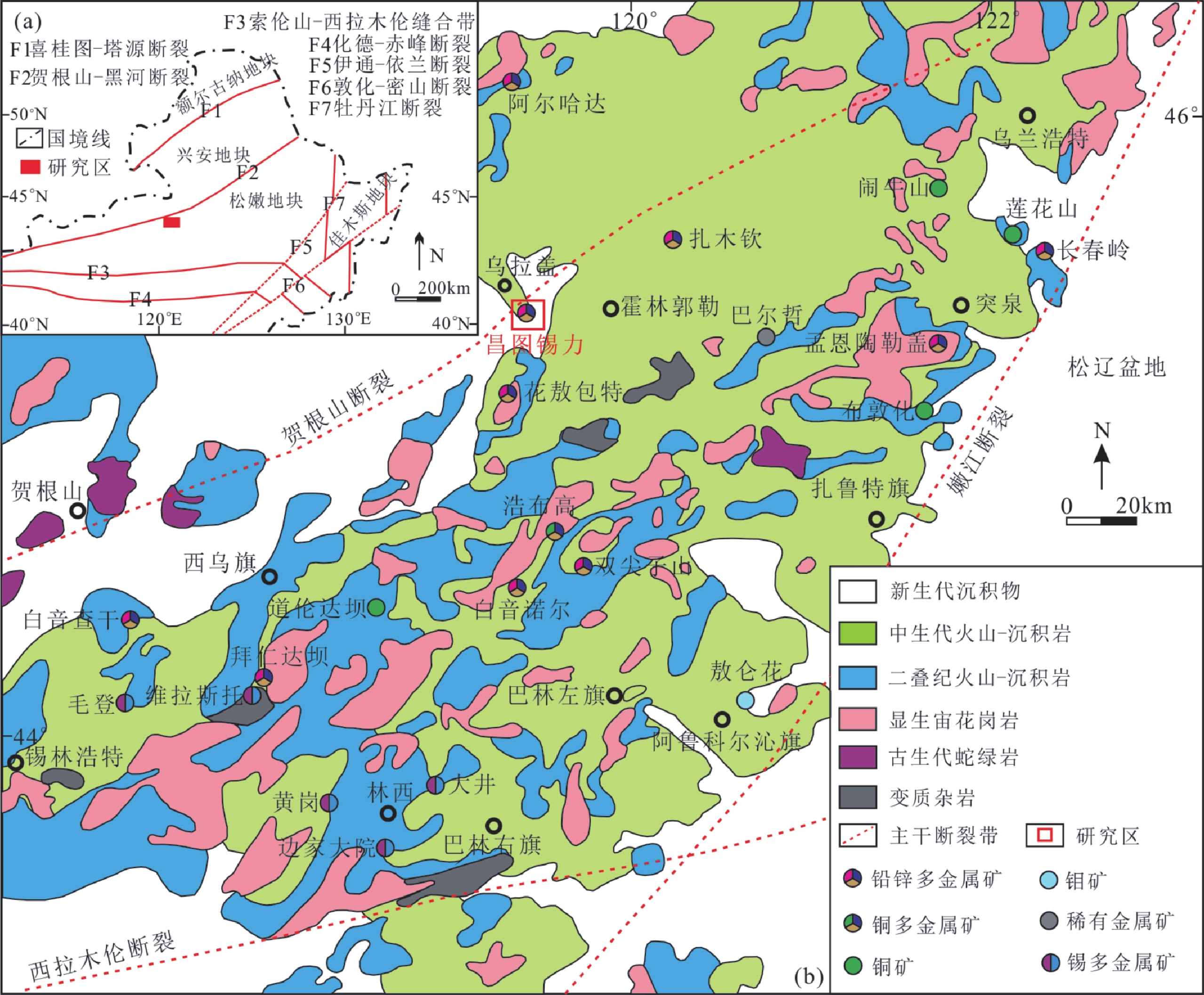
内蒙古昌图希勒斯台幅(L50E015021)1∶50 000矿产地质图数据库基于数字地质填图系统建立,实现了从前期资料准备→野外地质填图→室内综合整理→最终成果表达的全程数字化,有效开展了对各类数据的一体化描述、存储、组织和利用。数据库建立过程中采用“火山构造—岩性岩相—火山地层”填图方法,重新厘定了火山岩地层,详细划分了火山岩相、喷发旋回及其组合类型,重点查明了火山岩、火山构造、火山活动与成矿作用的关系,总结了中生代火山岩区金属矿产成矿地质条件和成矿规律。数据库的数据内容包含8个地层单位、4期火山喷发旋回、8处成矿远景区、6处找矿靶区,此外,还包含有1170件化学样品数据、261件土壤样分析数据、108件岩石地球化学数据、222件光薄片样品、35件S和Pb同位素数据、10件H和O同位素数据和4个锆石U–Pb年龄。初步查明图幅内新发现的昌图锡力银铅锌锰矿3341银金属量为1028.35 t,铅金属量为11.25万t,锌金属量为9.36万t,锰金属量为55.24万t,达到大型银多金属矿床规模。本数据库内容详实、可利用度高,为大兴安岭中南段中生代火山岩区深入开展矿产资源调查评价和金属矿产勘探开发提供了重要基础性数据资料支撑。
Abstract:In this paper, the database of 1∶50 000 mineral geological map of Changtuxilesitai Map-sheet (L50E015021), Inner Mongolia (also referred to as the Database) was established on the basis of digital geological mapping system, achieving the digitalization of the whole process of early data preparation → field geological mapping → indoor comprehensive data collation → the presentation of final results. Meanwhile, various relevant data were effectively described, stored, organized and utilized in an integrated way. The mapping method of “volcanic structure–lithology and lithofacies–volcanic strata” was adopted during the establishment of the Database. As a result, the volcanic strata were determined again, and the volcanic lithofacies as well as eruption cycles and their association types were classified in detail. Furthermore, the relationship of volcanics, volcanic structures and volcanic activities with mineralization were ascertained, and the geological conditions and metallogenic rule of metal minerals in Mesozoic volcanic areas were summarized. The Database contains eight stratigraphic units, four phases of volcanic eruption cycles, eight mineralization prospecting areas and six prospecting target areas. In addition, it also contains analytical data on 1170 pieces of rock samples and 261 pieces of samples for geochemistry, 108 pieces of samples for petrochemistry, 222 pieces of thin slice samples for petrography, 35 pieces of S and Pb isotopes, ten pieces of H and O isotopes, as well as four zircon U–Pb ages. The newly discovered Changtuxili Ag-Pb-Zn-Mn deposits in the map-sheet area have a roughly identified resource of 1028.35 tonnes of 3341 Ag, 112500 tonnes of Pb, 93600 tonnes of Zn and 552400 tonnes of Mn, belonging to a large-scale silver polymetallic deposit. The Database is detailed and accurate in contents and boasts high utility, providing important basic data for further survey and assessment of mineral resources, as well as the exploration and development of metal minerals in the area of Mesozoic volcanic rocks in the middle–southern section of the Da Hinggan Mountains.
-

-
表 1 数据库(集)元数据简表
条目 描述 数据库(集)名称 内蒙古昌图希勒斯台幅1∶50 000矿产地质图数据库 数据库(集)作者 何 鹏,中国地质调查局天津地质调查中心
郭 硕,中国地质调查局天津地质调查中心
苏 航,黑龙江省地质调查研究总院
王贵鹏,黑龙江省地质调查研究总院
张跃龙,黑龙江省地质调查研究总院数据时间范围 2017—2018年 地理区域 东经119°00′~119°15′,北纬45°30′~45°40′ 数据格式 MapGIS 数据量 6.27 MB 数据服务系统网址 http://dcc.cgs.gov.cn 基金项目 中国地质调查局地质调查项目“二连—东乌旗成矿带西乌旗和白乃庙地区地质矿产调查”(项目编号:DD2016041)资助 语种 中文 数据库(集)组成 昌图希勒斯台幅1∶50 000矿产地质图数据库包括1∶50 000矿产地质图库和图饰。地质图库包括火山岩、侵入岩、第四系、脉岩、构造、地质界线、产状、蚀变、岩性花纹、各类代号等;图饰包括接图表、图例、综合柱状图、图切剖面、矿化异常及编号、矿产远景区、所属成矿区带位置图、责任表  下载: 导出CSV
表 2 内蒙古昌图希勒斯台幅(L50E015021)1∶50 000矿产地质图数据库一览表
基本要素类 对象类 综合要素类 独立要素类 名称及标准编码 实体个数 名称及标准编码 说明 名称及标准编码 说明 名称及标准编码 地质体面实体(_GEOPOLYGON.WP) 82 沉积(火山)岩岩石地层单位(_STRATA) 包括第四系全新统冲积层(Qhal),第四系全新统冲湖积层(Qhall),第四系全新统冲洪积层(Qhalp),第四系全新统湖积层(Qhl),上侏罗统玛尼吐组一段(J3mn1),下白垩统白音高老组一段(K1b1),下白垩统白音高老组二段(K1b2),下白垩统大磨拐河组(K1d),新近系上新统宝格达乌拉组(N2b),新近系上新统五叉沟组(N2w)共10个 标准图框(_MAP_FRAME.WL) 标准图框内图框4条线,属性相同 接图表(MAP_SHEET) 地质界线(_GEOLINE.WL) 101 综合柱状图(COLUMN) 蚀变点(_ALTERATION_ PNT.WT) 63 图切剖面(PROFILE) 矿化点(_MINERAL_PNT.WT) 2 图例(LEGEND) 火山口(_CRATER.WT) 6 脉岩(_DIKE_OBJECT) 包括晚侏罗世安山岩脉(αJ3),早白垩世安山岩脉(αK1),晚侏罗世安山玢岩脉(αμJ3),晚侏罗世闪长玢岩脉(δμJ3),晚侏罗世英安岩脉(ζJ3),早白垩世流纹岩脉(λK1),早白垩世流纹斑岩脉(λπK1)共7个 火山岩相带(_VOLCA_FACIES) 主要有喷溢相(EFF)、爆发空落相(FOF)、火山碎屑流相(PRF)、火山通道相(VNF)、火山爆发崩塌相(VECF) 责任表(DUTY_TABLE) 产状(_ATTITUDE.WT) 30 样品(_SAMPLE.WT) 568 断层(_FAULT) 共18条 同位素(_ISOTOPE.WT) 4 面状河和水库(_WATER_REGION) 从地理底图中提取 蚀变带(_ALTERATION
_POLYGON)主要有铅锌矿化、褐铁矿化、硅化、碳酸盐化 其他(OTHER)主要包括火山岩相构造图、侵入岩单位划分及其他图廓外整饰 照片(_PHOTOGRAPH.WT) 186 河湖水库岸线(_LINE_GEOGRAPHY.WL) 50
下载: 导出CSV
表 3 内蒙古昌图希勒斯台幅(L50E015021)岩石地层单位划分一览表
界 系 统 组(段) 代号 岩石组合 同位素测年/Ma 新生界 新近系 上新统 五叉沟组 N2w 深灰、灰黑色、紫红色气孔状玄武岩、致密块状玄武岩、安山玄武岩、玄武质集块角砾岩、砂砾岩 宝格达乌拉组 N2b 砖红色(含砾)泥岩、含砾中粒长石岩屑杂砂岩、中粒岩屑长石杂砂岩、灰黑色泥岩、砂砾岩 中生界 白垩系 下统 大磨拐河组 K1d 以泥岩、粉砂岩为主,夹中、细粒砂岩、含砾砂岩,在泥岩、粉砂岩内夹煤层 梅勒图组 K1m 灰黑色、灰褐色、紫红色气孔状、杏仁状、致密块状玄武岩、安山岩、凝灰质(长石)岩屑砂岩、凝灰质砾岩、凝灰质砂砾岩、晶屑玻屑沉凝灰岩 白音高老组二段 K1b2 灰褐色、灰色、浅紫色流纹岩、流纹质(角砾)晶屑(玻屑、岩屑)凝灰岩、流纹质(角砾)晶屑熔结凝灰岩、球粒流纹岩,英安质晶屑凝灰岩、沉凝灰岩、松脂岩、珍珠岩、英安岩等 130±1
128.2±2.8白音高老组一段 K1b1 深灰、灰黑色、灰褐色英安质凝灰岩、流纹质(含角砾)晶屑凝灰岩、流纹质玻屑凝灰岩、英安质沉火山角砾岩、中、细粒岩屑长石砂岩、细砾岩、中、中粗砾砾岩、凝灰质砾岩、流纹岩、英安岩等 134.2±1
141.1±2.7侏罗系 上统 玛尼吐组二段 J3mn2 深灰、灰、灰紫、灰红、紫红色辉石粗面安山岩、石英粗安岩、粗安岩、粗面岩、粗面质英安岩、英安岩的岩石组合,火山机构附近可见粗面质、粗安质火山角砾岩、火山角砾集块岩 玛尼吐组一段 J3mn1 灰色、灰褐色、褐色、紫色安山岩、杏仁状安山岩、气孔状安山岩、英安岩、安山质集块火山角砾岩、安山质(含角砾)晶屑熔结凝灰岩、安山质晶屑凝灰岩、英安质晶屑熔结凝灰岩 154.7±1.3
下载: 导出CSV
表 4 内蒙古昌图希勒斯台幅(L50E015021)火山喷发旋回划分表
时代 火山喷发旋回 岩石地层 岩石组合 构造环境 上新世 4 五叉沟组 气孔杏仁状、致密块状玄武岩 早白垩世 3 梅勒图组 气孔杏仁状、致密块状玄武岩 大陆溢流玄武岩 2 白音高老组 流纹质晶屑凝灰岩、流纹质熔结凝灰岩、流纹岩、松脂岩、英安质晶屑凝灰岩、砾岩 活动大陆边缘 晚侏罗世 1 玛尼吐组 安山岩、气孔杏仁状安山岩、粗面岩、粗面英安岩、火山角砾岩、安山质晶屑熔结凝灰岩、安山质晶屑凝灰岩
下载: 导出CSV
表 5 内蒙古昌图希勒斯台幅(L50E015021)样品测试分析数据表
数据类型 数据量 数据属性 化学样 1170件 Ag、Pb、Zn、Mn、Cd等5项化学样分析 原岩光谱样 597件 Au、Ag、Cu、Pb、Zn、As、Sb、Sn、W、Mo、Cd、Mn
共12种元素分析岩石地球化学 108件 火山岩的11种主量元素、31种微量元素 光薄片 222件 透明矿物及金属矿物鉴定 S、Pb同位素 35件 金属矿物的S、Pb同位素分析 H、O同位素 10件 透明矿物的H、O同位素分析 同位素年龄数据 12件 火山岩的锆石U–Pb同位素年龄
下载: 导出CSV
Table 1. Metadata Table of Database (Dataset)
Item Description Database (dataset) name Database of 1∶50 000 Mineral Geological Map of Changtuxilesitai Map-sheet, Inner Mongolia Database (dataset) authors He Peng, Tianjin Center, China Geological Survey
Guo Shuo, Tianjin Center, China Geological Survey
Su Hang, Heilongjiang Institute of Geological Survey and Research
Wang Guipeng, Heilongjiang Institute of Geological Survey and Research
Zhang Yuelong, Heilongjiang Institute of Geological Survey and ResearchData acquisition time from 2017 to 2018 Geographical area 119°00′–119°15′E, 45°30′–45°40′N Data format MapGIS Data size 6.27 MB Data service system URL http://dcc.cgs.gov.cn Fund project China Geological survey project entitled Geological and Mineral Survey of Erenhot-East Ujimqin Banner Metallogenic Belt, West Ujimqin Banner, and Bainaimiao Area (No.: DD2016041) Language Chinese Database (dataset) composition The Database consists of a library of 1∶50 000 mineral geological map and map decorations. The former includes volcanics, intrusions, Quaternary strata, dikes, structures, geological boundaries, attitude, alteration, lithologic pattern and all kinds of symbols. The latter includes an index map, legends, synthetic histograms, transverse cutting profiles, mineralization anomalies and their numbers, mineral prospect areas, maps of locations of their metallogenic belts and a duty table
下载: 导出CSV
Table 2. Information list of the database of 1∶50 000 mineral geological map of Changtuxilesitai Map-sheet (L50E015021), Inner Mongolia
Basic feature class Object class Complex class Independent feature class Name and standard code Entity quantity Name and standard code Description Name and standard code Description Name and standard code Geological polygon entity (_GEOPOLYGON.WP) 82 Lithostratigraphic unit of sedimentary (volcanic) rocks (_STRATA) Including ten strata, namely Quaternary Holocene alluvial deposit (Qhal), Quaternary Holocene alluvial-lacustrine deposit (Qhall), Quaternary Holocene alluvial-diluvial deposit (Qhalp), Quaternary Holocene lacustrine deposit (Qhl), the first member of Upper Jurassic Manitu Formation (J3mn1), the first member of Lower Cretaceous Baiyingaolao Formation (K1b1), the second member of Lower Cretaceous Baiyingaolao Formation (K1b2), Lower Cretaceous Damoguaihe Formation (K1d), Neogene Pliocene Baogedawula Formation (N2b), and Neogene Pliocene Wuchagou Formation (N2w) Standard map frame (_MAP_FRAME.WL) Four lines of inner map frame (standard frame), with same attributes Map index (MAP_SHEET) Geological boundary (_GEOLINE.WL) 101 Comprehensive histogram (COLUMN) Alteration point (_ALTERATION_ PNT.WT) 63 Transverse cutting profile (PROFILE) Mineralized point (_MINERAL_PNT.WT) 2 Legend (LEGEND) Crater (_CRATER.WT) 6 Dike (_DIKE_OBJECT) Including seven dikes, namely late Jurassic andesitic dike (αJ3), early Cretaceous andesitic dike (αK1), late Jurassic andesitic porphyrite dike (αμJ3), late Jurassic diorite porphyrite dike (δμJ3), late Jurassic dacite dike (ζJ3), early Cretaceous rhyolite dike (λK1), early Cretaceous rhyolite porphyry dike (λπK1) Volcanic lithofacies zone (_VOLCA_FACIES) Mainly including effusive facies (EFF), fallout facies (FOF), pyroclasic flow facies (PRF), volcanic vent facies (VNF), and volcanic explosion-collapse facies (VECF) Duty table (DUTY_TABLE) Attitude (_ATTITUDE.WT) 30 Sample (_SAMPLE.WT) 568 Fault (_FAULT) 18 in total Isotope (_ISOTOPE.WT) 4 Planar river and reservoir (_WATER
_REGION)Extracted from geographical base map Alteration zone (_ALTERATION
_POLYGON)Mainly including Pb–Zn mineralization, limonitization, Silicification, and carbonatization Other (OTHER) mainly includes volcanic lithofacies tectonic map, units of intrusions and other map decorations outside map border Photo (_PHOTOGRAPH.WT) 186 Bank line of river, lake, and reservoir (_LINE_GEOGRAPHY.WL) 50
下载: 导出CSV
Table 3. Lithostratigraphic units in Changtuxilesitai Map-sheet (L50E015021), Inner Mongolia
Erathem System Series Formation (member) Code Rock association Isotopic dating /Ma Cenozoic Neogene Pliocene Wuchagou Formation N2w Dark-gray, grayish-black and amaranthine vesicular basalt, dense massive basalt, andesitic basalt, basaltic agglomeratic breccia, sandy conglomerate Baogedawula Formation N2b Brick-red (pebbly) mudstone, pebbly medium-grained feldspathic lithic greywacke, medium-grained lithic feldspathic greywacke, grayish dark mudstone, and sandy conglomerate Mesozoic Cretaceous Lower Cretaceous Damoguaihe Formation K1d Mainly consisting of mudstone and siltstone, interbedded with medium- and fine-grained sandstone and pebbly sandstone as well as coal seams Meiletu Formation K1m Grayish-black, grayish-brown, and amaranthine vesicular, amygdaloidal, and dense massive basalt, andesite, tuffaceous (feldspathic) lithic sandstone, tuffaceous conglomerate, tuffaceous sandy conglomerate, and crystal vitric sedimentary tuff The second member of Baiyingaolao Formation K1b2 Grayish-brown, gray, light purple rhyolite, rhyolitic (brecciaceous) crystal (vitric, lithic) tuff, rhyolitic (brecciaceous) crystal ignimbrite, pelletized rhyolite, dacitic crystal tuff, sedimentary tuff, pitchstone, perlite, dacite, etc. 130±1
128.2±2.8The first member of Baiyingaolao Formation K1b1 Dark-gray, grayish-black, and grayish-brown dacitic tuff, rhyolitic (brecciaceous) crystal tuff, rhyolitic vitric tuff, dacitic tuff sendimentary volcanic breccia, medium- and fine-grained lithic feldspathic sandstone, fine-grained conglomerate, medium-grained and medium-coarse grained conglomerate, tuffaceous conglomerate, rhyolite, dacite, etc. 134.2±1
141.1±2.7Jurassic Upper Jurassic The second member of Manitu Formation J3mn2 Consisting of dark-gray, gray, grayish-purple, grayish-red, and amaranthine pyroxene-bearing trachyandesite, quartz trachyandesite, trachyandesite, trachyte, trachydacite, and dacite. Trachytic and trachyandesitic volcanic breccia and volcanic brecciaceous agglomerate are visible near volcanic edifice The first member of Manitu Formation J3mn1 Gray, grayish-brown, brown, and purple andesite, amygdaloidal andesite, vesicular andesite, dacite, andesitic agglomeratic volcanic breccia, andesitic (brecciaceous) crystal ignimbrite, andesitic crystal tuff, and dacitic crystal ignimbrite 154.7±1.3
下载: 导出CSV
Table 4. Volcanic eruption cycles in Changtuxilesitai Map-sheet (L50E015021), Inner Mongolia
Era Volcanic eruption cycle Rock stratum Rock association Tectonic environment Pliocene 4 Wuchagou Formation Vesicular, amygdaloidal, and dense massive basalt Early Cretaceous 3 Meiletu Formation Vesicular, amygdaloidal, and dense massive basalt Continental flood basalts 2 Baiyingaolao Formation Rhyolitic crystal tuff, rhyolitic ignimbrite, rhyolite, pitchstone, andesitic crystal tuff, and conglomerate Active continental margin Late Jurassic 1 Manitu Formation Andesite, vesicular and amygdaloidal andesite, trachyte, trachydacite, volcanic breccia, andesitic crystal ignimbrite, andesitic crystal tuff
下载: 导出CSV
Table 5. Analytical data list of the samples collected in the Changtuxilesitai Map-sheet (L50E015021) area, Inner Mongolia
Data type Number of samples Data description Samples for chemistry 1170 Five metal elements of Ag, Pb, Zn, Mn, Cd Samples for rock spectroscopy 597 12 elements of Au, Ag, Cu, Pb, Zn, As, Sb, Sn, W, Mo, Cd, Mn Samples for petrochemistry 108 11 main elements and 31 trace elements of volcanic rocks Samples for thin slice identification 222 Microscopic petrography identification of the transparent and metallic minerals Samples for S and Pb isotopes 35 S and Pb isotopic analysis on the metallic minerals Samples for H and O isotopes 10 H and O isotopic analysis on the transparent minerals Samples for isotopic dating 12 Zircon U–Pb dating ages of the volcanic rocks
下载: 导出CSV
-
[1] Jahn BM, Wu FY, Chen B. 2000. Grantitoids of the central Asian orogenic belt and continental growth in the Phanerozoic[J]. Earth and Environmental Science Transactions of the Royal Society of Edinburgh, 91(1-2): 181−193. doi: 10.1017/S0263593300007367
[2] Meng QR. 2003. What drove late Mesozoic extension of the northern China-Mongolia trace?[J]. Tectonophysics, 369(3): 155−174.
[3] Ouyang HG, Wu XL, Mao JW, Su HM, M Santosh, Zhou ZH, Li C. 2014. The nature and timing of ore formation in the Budunhua Copper Deposit, southern great Xingan range: evidence from geology, fluid inclusions, and U-Pb and Re-Os geochronology[J]. Ore Geology Reviews, 63: 238−251. doi: 10.1016/j.oregeorev.2014.05.016
[4] Wu FY, Sun DY, Ge WC, Zhang YB, Grant M L, Wilde SA, Jahn BM. 2011. Geochronology of the phanerozoic granitoids in northeastern china[J]. Journal of Asian Earth Sciences, 41(1): 1−30. doi: 10.1016/j.jseaes.2010.11.014
[5] Xiao WJ, Windley BF, Hao J, Zhai MG. 2003. Accretion Leading to Collision and the Permian Solonker sutute, Inner Mongolia, China: termination of the Central Asian Orogenic Belt[J]. Tectonic, 22(6): 1484−1505. http://onlinelibrary.wiley.com/doi/10.1029/2002TC001484/pdf
[6] Xu WL, Ji WQ, Pei FP, Meng E, Yu Y, Yang DB, Zhang XZ. 2009. Triassic volcanism in eastern Heilongjiang and Jilin provinces, NE China: Chronology, geochemistry, and tectonic implications[J]. Journal of Asian Earth Sciences, 34(3): 392−402. doi: 10.1016/j.jseaes.2008.07.001
[7] Zeng QD, Liu JM, Yu CM, Ye J and Liu HT. 2011. Metal deposits in the Da Hinggan Mountains, NE China: Styles, characteristics, and exploration potential[J]. International Geology Review, 53(7): 846−878. doi: 10.1080/00206810903211492
[8] 陈良, 张达, 狄永军, 徐俊, 王策, 宛胜, 来守华. 2009. 大兴安岭中南段区域成矿规律初步研究[J]. 地质找矿论丛, 24(4): 267−271, 281.
[9] 盛继福, 付先政. 1999. 大兴安岭中段成矿环境与铜多金属矿床地质特征[M]. 北京: 地震出版社: 1–216.
[10] 葛文春, 吴福元, 周长勇, 张吉衡. 2007. 兴蒙造山带东段斑岩型Cu, Mo矿床成矿时代及其地球动力学意义[J]. 科学通报, 52(20): 2407−2417. doi: 10.3321/j.issn:0023-074x.2007.20.012
[11] 何鹏, 郭硕, 张阔, 张天福, 苏航, 马一行. 2019. 大兴安岭中南段昌图锡力银铅锌锰多金属矿床成矿物质来源及矿床成因: 来自S-Pb-C-O同位素的制约[J]. 地质学报, 93(8): 2037−2054. doi: 10.3969/j.issn.0001-5717.2019.08.014
[12] 何鹏, 郭硕, 苏航, 王贵鹏, 张跃龙. 2020. 内蒙古昌图希勒斯台幅 1∶50 000 矿产地质图数据库[DB/OL]. 地质科学数据出版系统. (2020-12-30).DOI: 10.35080/data.C.2020.P24.
[13] 李俊建, 付超, 唐文龙, 李惠民, 林源贤, 张彤, 王守光, 赵泽霖, 党智财, 赵丽君. 2016. 内蒙古东乌旗沙麦钨矿床的成矿时代[J]. 地质通报, 35(4): 524−530. doi: 10.3969/j.issn.1671-2552.2016.04.005
[14] 刘光鼎, 涂光炽, 刘东生. 2003. 大兴安岭中南段—一个重要的有色金属资源基地[J]. 中国科学院院刊, 18(5): 324−325. doi: 10.3969/j.issn.1000-3045.2003.05.002
[15] 刘建明, 张锐, 张庆洲. 2004. 大兴安岭地区的区域成矿特征[J]. 地学前缘, 11(1): 269−277. doi: 10.3321/j.issn:1005-2321.2004.01.024
[16] 毛景文, 谢桂青, 张作衡, 李晓峰, 王义天, 张长青, 李永峰. 2005. 中国北方中生代大规模成矿作用的期次及其地球动力学背景[J]. 岩石学报, 21(1): 169−188. doi: 10.3321/j.issn:1000-0569.2005.01.017
[17] 孟恩, 许文良, 杨德彬, 邱昆峰, 李长华, 祝洪涛. 2011. 满洲里地区灵泉盆地中生代火山岩的锆石U-Pb年代学、地球化学及其地质意义[J]. 岩石学报, 27(4): 1209−1226.
[18] 任纪舜, 牛宝贵, 刘志刚. 1999. 软碰撞、叠覆造山和多旋回缝合作用[J]. 地学前缘, 6(3): 85−93. doi: 10.3321/j.issn:1005-2321.1999.03.008
[19] 邵积东, 陶继雄, 李四娃, 尚恒胜, 武利文, 巩智镇, 李甫. 2009. 大兴安岭成矿带找矿工作新进展[J]. 地质通报, 28(7): 955−962. doi: 10.3969/j.issn.1671-2552.2009.07.015
[20] 王京彬, 王玉往, 王莉娟. 2000. 大兴安岭中南段铜矿成矿背景及找矿潜力[J]. 地质与勘探, 36(5): 1−4.
[21] 王长明, 张寿庭, 邓军. 2006. 大兴安岭南段铜多金属矿成矿时空结构[J]. 成都理工大学学报(自然科学版), 33(5): 478−484. doi: 10.3969/j.issn.1671-9727.2006.05.008
[22] 吴福元, 葛文春, 孙德有, 郭春丽. 2003. 中国东部岩石圈减薄研究中的几个问题[J]. 地学前缘, 10(3): 51−60. doi: 10.3321/j.issn:1005-2321.2003.03.004
[23] 武新丽, 毛景文, 周振华, 欧阳荷根. 2012. 大兴安岭中南段布敦化铜矿床H-O-S-Pb同位素特征及成矿指示[J]. 中国地质, 39(6): 1812−1829. doi: 10.3969/j.issn.1000-3657.2012.06.026
[24] 杨海星, 高利东, 高玉石, 隋海涛, 赵志飞, 吕晶, 张维宇, 赵胜金, 柳志辉, 周颖帅. 2019. 大兴安岭中南段梅勒图组层型剖面锆石U-Pb年龄、地球化学特征及其地质意义[J]. 地质通报, 38(5): 845−857.
[25] 要梅娟, 刘家军, 翟德高, 王建平, 邢永亮. 2012. 大兴安岭南段多金属成矿带硫、铅同位素组成及其地质意义[J]. 吉林大学学报(地球科学版), 42(2): 362−373.
[26] 曾庆栋, 刘建明, 禇少雄, 郭云鹏, 高帅, 郭理想, 翟媛媛. 2016. 大兴安岭南段多金属矿成矿作用和找矿潜力[J]. 吉林大学学报(地球科学版), 46(4): 1100−1123.
[27] 张海华, 张健, 黄欣, 邱亮, 苏飞, 郑月娟, 张德军. 2019. 大兴安岭中部乌兰浩特地区林西组碎屑岩锆石U-Pb年龄、地球化学特征及其构造意义[J]. 地质通报, 38(9): 1484−1500.
[28] 张万益, 聂凤军, 刘树文, 左力艳, 陕亮, 姚晓峰. 2013. 大兴安岭南段西坡金属矿床特征及成矿规律[J]. 中国地质, 40(5): 1583−1599. doi: 10.3969/j.issn.1000-3657.2013.05.022
[29] 郑全波, 苏航, 何鹏, 张跃龙, 郑涛. 2019. 内蒙古昌图锡力地区锰银铅锌多金属矿的找矿标志[J]. 地质调查与研究, 42(1): 37−44.
[30] 仲米山, 王忠江, 敖光, 翟富荣, 王粉丽, 王岐, 谭超, 杨运来. 2017. 张广才岭二浪河组火山岩的锆石U-Pb年代学及地球化学特征[J]. 地质调查与研究, 40(3): 161−168. doi: 10.3969/j.issn.1672-4135.2017.03.001
[1] Chen Liang, Zhang Da, Di Yongjun, Xu Jun, Wang Ce, Wan Sheng, Lai Shouhua. 2009. A study on the regional metallogenic regularity in the mid-southern segment of Da Hinggan Mountains, China[J]. Contributions to Geology and Mineral Resources Research, 24(4): 267−271, 281 (in Chinese with English abstract).
[2] Ge Wenchun, Wu Fuyuan, Zhou Changyong, Zhang Jiheng. 2007. Metallogenic age of the porphyry Cu, Mo deposit in the eastern Xingmeng orogenic belt and its geodynamic significance[J]. Chinese Science Bulletin, 52(20): 2407−2417 (in Chinese). doi: 10.1360/csb2007-52-20-2407
[3] He Peng, Guo Shuo, Zhang Kuo, Zhang Tianfu, Su Hang, Ma Yixing. 2019. The sources of ore-forming materials and genesis of the Changtuxili Ag-Pb-Zn-Mn polymetallic deposit in the middle–southern segment of Da Hinggan Mountains: Constraints from S-Pb-C-O isotope geochemistry[J]. Acta Geologica Sinica, 93(8): 2037−2054 (in Chinese with English abstract).
[4] He Peng, Guo Shuo, Su Hang, Wang Guipeng, Zhang Yuelong. 2020. Database of 1∶50 000 Mineral Geological Map of Changtuxilesitai Map-sheet, Inner Mongolia[DB/OL]. Geoscientific Data & Discovery Publishing System. (2020-12-30). DOI: 10.35080/data.C.2020.P24.
[5] Jahn BM, Wu FY, Chen B. 2000. Grantitoids of the central Asian orogenic belt and continental growth in the Phanerozoic[J]. Earth and Environmental Science Transactions of the Royal Society of Edinburgh, 91(1–2): 181−193.
[6] Li Junjian, Fu Chao, Tang Wenlong, Li Huimin, Lin Yuanxian, Zhang Tong, Wang Shouuang, Zhao Zelin, Dang Zhicai, Zhao Lijun. 2016. The metallogenic age of the Shamai wolframite deposit in Dong Ujimqin Banner, Inner Mongolia[J]. Geological Bulletin of China, 35(4): 524−530 (in Chinese with English abstract).
[7] Liu Guangding, Tu Guangchi, Liu Dongsheng. 2003. Middle–southern segment of Da Hinggan Mountains—an important non-ferrous metal resource base[J]. Bulletin of the Chinese Academy of Sciences, 18(5): 324−325 (in Chinese).
[8] Liu Jiamin, Zhang Rui, Zhang Qingzhou. 2004. The reginal metallogeny of Da Hinggan Ling, China[J]. Earth Science Frontiers, 11(1): 269−277 (in Chinese with English abstract).
[9] Mao Jingwen, Xie Guiqing, Zhang Zuoheng, Li Xiaofeng, Wang Yitian, Zhang Changqing, Li Yongfeng. 2005. Mesozoic large-scale metallogenic pulses in North China and corresponding geodynamic settings[J]. Acta Petrologica Sinica, 21(1): 169−188 (in Chinese with English abstract).
[10] Meng En, Xu Wenliang, Yang Debin, Qiu Kunfeng, Li Changhua, Zhu Hongtao. 2011. Zircon U-Pb chronology, geochemistry of Mesozoic volcanic rocks from the Lingquan basin in Manzhouli area, and its tectonic implications[J]. Acta Petrologica Sinica, 27(4): 1209−226 (in Chinese with English abstract).
[11] Meng QR. 2003. What drove late Mesozoic extension of the northern China-Mongolia trace?[J]. Tectonophysics, 369(3): 155−174.
[12] Ouyang HG, Wu XL, Mao JW, Su HM, M Santosh, Zhou ZH, Li C. 2014. The nature and timing of ore formation in the Budunhua Copper Deposit, southern great Xingan range: evidence from geology, fluid inclusions, and U-Pb and Re-Os geochronology[J]. Ore Geology Reviews, 63: 238−251. doi: 10.1016/j.oregeorev.2014.05.016
[13] Ren Jishun, Niu Baogui, Liu Zhigang. 1999. Soft collision, superposition orogeny and polycyclic suturing[J]. Earth Science Frontiers, 6(3): 85−93 (in Chinese with English abstract).
[14] Shao Jidong, Tao Jixiong, Li Siwa, Shang Hengsheng, Wu Liwen, Kong Zhizhen, Li Fu. 2009. The new progress in ore prospecting within Daxing’anling mineralization belt, China[J]. Geological Bulletin of China, 28(7): 955−962 (in Chinese with English abstract).
[15] Sheng Jifu, Fu Xianzheng. 1999. Metallogenic environment and geological characteristics of copper-polymetallic deposits in the middle segment of Da Hinggan Mountains[M]. Beijing: Seismological Press. 1–216 (in Chinese).
[16] Wang Jingbin, Wang Yuwang, Wang Lijuan. 2000. Copper metallogenic setting and prospecting potential in the middle-southern part of Da Hinggan Mountains[J]. Geology and Prospecting, 36(5): 1−4 (in Chinese with English abstract).
[17] Wang Changmin, Zhang Shouting, Deng Jun. 2006. The metallogenic space-time structure of copper-polymetallic deposits in the southern segment of Da Hinggan Mountains, China[J]. Journal of Chengdu University of Technology (Science & Technology Edition), 33(5): 478−484 (in Chinese with English abstract).
[18] Wu Fuyuan, Ge Wenchun, Sun Deyou, Guo Chunli. 2003. Discussions on the lithospheric thinning in eastern China[J]. Earth Science Frontiers, 10(3): 51−60 (in Chinese with English abstract).
[19] Wu FY, Sun DY, Ge WC, Zhang YB, Grant M L, Wilde SA, Jahn BM. 2011. Geochronology of the phanerozoic granitoids in northeastern China[J]. Journal of Asian Earth Sciences, 41(1): 1−30. doi: 10.1016/j.jseaes.2010.11.014
[20] Wu Xinli, Mao Jingwen, Zhou Zhenhua, Ouyang Hegen. 2012. H-O-S-Pb isotopic components of the Budunhua Cu deposit in the middle-south part of the Da Hinggan Mountains and their implications for the ore-forming process[J]. Geology in China, 39(6): 1812−1829 (in Chinese with English abstract).
[21] Xiao WJ, Windley BF, Hao J, Zhai MG. 2003. Accretion Leading to Collision and the Permian Solonker sutute, Inner Mongolia, China: termination of the Central Asian Orogenic Belt[J]. Tectonic, 22(6): 1484−1505.
[22] Xu WL, Ji WQ, Pei FP, Meng E, Yu Y, Yang DB, Zhang XZ. 2009. Triassic volcanism in eastern Heilongjiang and Jilin provinces, NE China: Chronology, geochemistry, and tectonic implications[J]. Journal of Asian Earth Sciences, 34(3): 392−402. doi: 10.1016/j.jseaes.2008.07.001
[23] Yang Haixing, Gao Lidong, Gao Yushi, Sui Haitao, Zhao Zhifei, Lü Jing, Zhang Weiyu, Zhao Shengjin, Liu Zhihui, Zhou Yingshu. 2019. Zircon U-Pb age and geochemistry of the stratotype section of the Meiletu Formation in middle southern Da Hinggan Mountains and its geological significance[J]. Geological Bulletin of China, 38(5): 845−857 (in Chinese with English abstract).
[24] Yao Meijuan, Liu Jiajun, Zhai Degao, Wang Jianping, Xing Yongliang. 2012. Sulfur and lead isotopic compositions of the Polymetallic deposits in the southern Daxing’anling: Implications for metal sources[J]. Journal of Jilin Unviersity (Earth Science Edition), 42(2): 362−373 (in Chinese with English abstract).
[25] Zeng QD, Liu JM, Yu CM, Ye J and Liu HT. 2011. Metal deposits in the Da Hinggan Mountains, NE China: Styles, characteristics, and exploration potential[J]. International Geology Review, 53(7): 846−878. doi: 10.1080/00206810903211492
[26] Zeng Qingdong, Liu Jianming, Chu Shaoxiong, Guo Yunpeng, Gao Shuai, Guo Lixiang, Zhai Yuanyuan. 2016. Poly-Metal Mineralization and Exploration Potential in Southern Segment of the Da Hinggan Mountains[J]. Journal of Jilin Unviersity (Earth Science Edition), 46(4): 1100−1123 (in Chinese with English abstract).
[27] Zhang Haihua, Zhang Jian, Huang Xin, Qiu Liang, Su Fei, Zheng Yuejuan, Zhang Dejun. 2019. Zircon U-Pb age, geochemical characteristics and tectonic implications of detrital zircon from Linxi Formation in the Wulanhaote area, central Da Hinggan Mountains[J]. Geological Bulletin of China, 38(9): 1482−1500 (in Chinese with English abstract).
[28] Zhang Wanyi, Nie Fengjun, Liu Shuwen, Zuo Liyan, Shan Liang, Yao Xiaofeng. 2013. Characteristics and metallogenic regularities of ore deposits on the western slope of the southern section of the Da Hinggan Mountains metallogenic belt[J]. Geology in China, 40(5): 1583−1599 (in Chinese with English abstract).
[29] Zheng Quanbo, Su Hang, He Peng, Zhang Yuelong, Zheng Tao. 2019. The prospecting criteria of Mn-Ag-lead-zinc polymetallic ore in Changtuxili area of Inner Mongolia[J]. Geological Survey and Research, 42(1): 37−44 (in Chinese with English abstract
[30] Zhong Mishan, Wang Zhongjiang, Ao Guang, Zhai Furong, Wang Fenli, Wang Qi, Tanchao, Yang Yunlai. 2017. Zircon U-Pb chronology and geochemical characteristics of the volcanic rocks from Erlanghe formation in Zhangguangcai range[J]. Geological Survey and Research, 40(3): 161−168 (in Chinese with English abstract).
-

图(2)
表(10)
计量
- 文章访问数: 1698
- PDF下载数: 166
- 施引文献: 0