

Spatiotemporal evolution and influencing factors of coastline in the Guangdong-Hong Kong-Macao Greater Bay Area from 1975 to 2018
-
摘要:
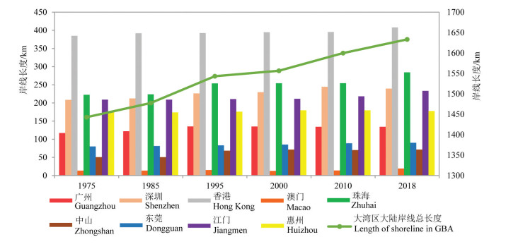
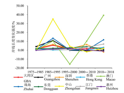
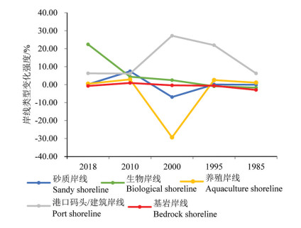
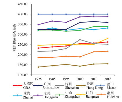
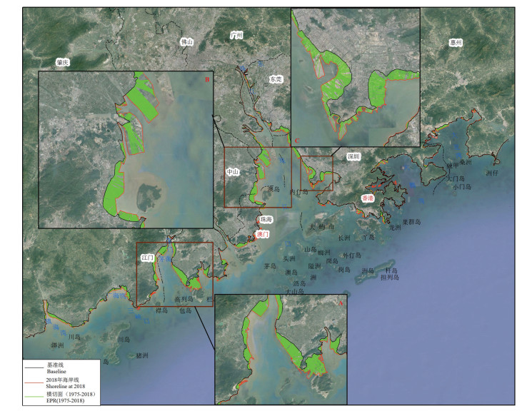
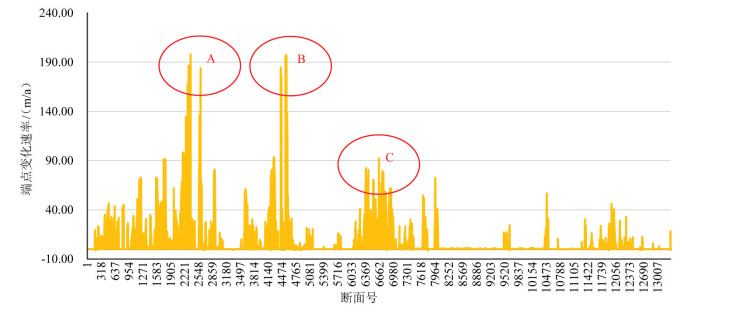
海岸带是陆地向海洋延伸的过渡地带,是人口最为密集、人类活动最频繁的区域,全球超过50%的人口和60%的GDP总量集聚在离海岸线不足100 km的区域。海岸线对海平面上升、海岸侵蚀、港湾淤积、湿地生态资源、近海海域环境等具有重要的指示作用。本研究利用遥感影像获取了粤港澳大湾区(以下简称大湾区)1975—2018年间的大陆海岸线数据,并基于GIS平台,对海岸线开发利用程度以及空间位置变迁进行了定量分析,探讨了海岸线变迁的驱动力。结果表明:(1)大湾区大陆岸线时空变化明显,总体可分为两个阶段。1975—1995年,岸线长度上升明显,岸线类型格局变化显著;1995年后,岸线长度增长较缓,但建设用地态势增长强劲。(2)大湾区大陆岸线整体形态上不断曲折化,分形维数逐渐增长;空间位置变化上,大陆岸线不断向海推进,年平均速率达9.91 m/a,向海延伸最远的地方出现在洪奇门至蕉门和虎跳门至鸡啼门岸段附近,最大值可达197.88 m/a。(3)大湾区大陆岸线的开发利用程度及人类活动干预程度处于逐渐增强的趋势,人为影响主要体现为港口码头建筑岸线及围填养殖岸线。(4)大湾区的地形地貌、水文特征等自然环境是岸线演变的基础,社会经济发展和政策是岸线演变的重要驱动因素。在20世纪末,发展速度对海岸线的影响最大;在21世纪初,发展强度则为演变的主要影响因素。
Abstract:Coastline transitionally extending from land to sea is the most densely populated area with the most frequent human activities. More than 50% of the global population and 60% of GDP are concentrated in the area less than 100 km away from the coastline. Coastline plays an important indicator role in sea level rise, coastal erosion, estuary siltation, wetland ecological resources, and coastal environment, etc. Remote sensing images were interpreted to acquire data about coastline of Guangdong-Hong Kong-Macao Greater Bay Area(GBA) from 1975 to 2018. Based on GIS platform, the spatio-temporal changes and influencing factors of shoreline were analyzed. The results reveal that the mainland coastline in GBA witnessed significant temporal and spatial changes, which could be divided into two stages. From 1975 to 1995, the length of shoreline increased significantly, the pattern of shoreline type changed significantly; after 1995, the coastline length increased slowly, but the construction land increased strongly. From 1975 to 2018, the coastline of GBA became more and more tortuous, and the fractal dimension increased. In terms of spatial position change, the coastline of the mainland continued to advance toward the sea, with an average rate of 9.91 m/a. The farthest extension to the sea occurred from Hongqimen to Jiaomen and from Hutiaomen to Jitimens with the maximum rate of 197.88 m/a. The development and utilization of the mainland coastline and the intervention of human activities on coastline evolution in GBA increased gradually. The main shorelines affected by human activities were port construction shoreline and reclamation aquaculture shoreline. The natural environment of GBA, such as topography and hydro-logical characteristics was the basis of coastline evolution. Social and economic development and policies were the important driving factors of coastline evolution. At the end of the 20th century, the development speed had the greatest impact on the coastline, and the development intensity was still the main factor at the beginning of the 21st century.
-
Key words:
- shoreline change /
- Guangdong /
- Hong Kong /
- Macao /
- GIS
-

-
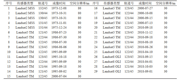
表 1 大湾区大陆海岸线遥感数据源信息
Table 1. The data sources and description of shoreline in Guangdong-Hong Kong-Macao Greater Bay
 下载: 导出CSV
表 2 大湾区大陆岸线开发利用强度指数表
Table 2. Utilization strength index of the coastline in Guangdong-Hong Kong-Macao Greater Bay Area
 下载: 导出CSV
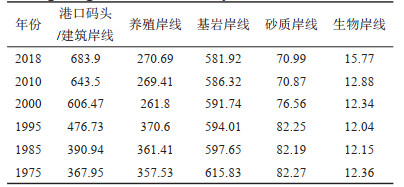
表 3 大湾区大陆岸线类型长度(km)统计(1975—2018年)
Table 3. The shoreline type length changes of GuangdongHong Kong-Macao Greater Bay Area from 1975 to 2018
 下载: 导出CSV
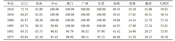
表 4 大湾区大陆岸线人工化指数(%)统计(1975—2018年)
Table 4. Artificial shoreline index of Guangdong-Hong Kong-Macao Greater Bay Area from 1975 to 2018
 下载: 导出CSV
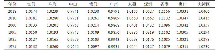
表 5 大湾区大陆岸线分形维数变化统计(1975—2018年)
Table 5. The shoreline fractal features changes of Guangdong-Hong Kong-Macao Greater Bay Area from 1975 to 2018
 下载: 导出CSV
-
Ai B, Zhang R, Zhang H. 2019. Dynamic process and artificial mechanism of coastline change in the Pearl River Estuary[J]. Regional Studies in Marine Science, 30: 100715. doi: 10.1016/j.rsma.2019.100715
Addo K A, Walkden M, Mills J P. 2008. Detection, measurement and prediction of shoreline recession in Accra, Ghana[J]. Remote Sensing, 63 (5): 543-558. http://www.sciencedirect.com/science/article/pii/S0924271608000282
Boye C B, Addo K A, Wiafe G, Dzigbodi-Ad Jimah K. 2018. Spatio-temporal analyses of shoreline change in the Western Region of Ghana[J]. Journal of Coastal Conservation, 22 (4): 769-776. doi: 10.1007/s11852-018-0607-z
Bheeroo R A, Chandrasekar N, Kaliraj S, Magesh N S. 2016. Shoreline change rate and erosion risk assessment along the Trou Aux Biches-Mont Choisy beach on the northwest coast of Mauritius using GIS-DSAS technique[J]. Environmental Earth Sciences, 75(5): 1-12. doi: 10.1007/s12665-016-5311-4
Da Voodi H, Gharibreza M, Negarestan H, Mortazavi, M S, Lak R. 2017. Ecological risk assessment of the Assaluyeh and Bassatin estuaries (northern Persian Gulf) using sediment quality indices[J]. Estuarine Coastal & Shelf Science, 192: 17-28. http://www.sciencedirect.com/science/article/pii/S0272771417304882
Gao Zhiqiang, Liu Xiangyang, Ning Jicai, Lu Qingshui. 2014. Analysis on changes in coastline and reclamation area and its causes based on 30-year satellite data in China[J]. Transactions of the Chinese Society of Agricultural Engineering, 30(12): 140-147(in Chinese with English abstract).
He Gaili, LI Jialin, Liu Yongchao, Shi Xiaoli, Ma Jingwu. 2019. Spatio-temporal analysis of land development and utilization intensity in Tampa Bay watershed from 1985 to 2015[J]. Journal of Natural Resources, 34(1): 66-79(in Chinese with English abstract). doi: 10.31497/zrzyxb.20190106
Hou Xiyong, Wu Ting, Hou Wan, Chen Qing, Wang Yuandong, Yu Liangju. 2016. Characteristics of coastline changes in mainland China since the early 1940s[J]. Science China Earth Sciences, 59(9): 1791-1802. doi: 10.1007/s11430-016-5317-5
Jayakumar K, Malarvannan S. 2016. Assessment of shoreline changes over the Northern Tamil Nadu Coast, South India using Web GIS techniques[J]. Journal of Coastal Conservation, 20 (6): 477-487. doi: 10.1007/s11852-016-0461-9
Li Jialin, Tian Peng, Shao Shuyao, Wang Haifeng, Wang Lijia, Ye Mengyao. 2019. The change of continental coastline and its development and utilization intensity in the East China Sea[J]. Journal of Image and Graphics, 9(10): 1249-1257(in Chinese with English abstract). http://www.researchgate.net/publication/350732147_The_change_of_continental_coastline_and_its_development_and_utilization_intensity_in_the_East_China_Sea
Liu Feng, Tan Chao, Kun Song. 2015. Study on the evolution of the mud in the mud of the Ramen of the Pearl River after mass reclamation[C]//"One Belt One Road" Strategy and Marine Technology Innovation——Collection of Academic Papers of China Ocean Society(in Chinese).
Li Hongyuan, Wang Zhongliang, Meng Weiqing, Mo Xunqiang. 2017. Temporal-spatial variations and driving factors analysis of coastal reclamation in China[J]. Estuarine coastal and shelf science, 191: 39-49. doi: 10.1016/j.ecss.2017.04.008
Li Xulong, Deng Ruru, Xu Jianhui, Gong Qinghua. 2017. Spatiotemporal evolution characteristics of coastlines and driving force analysis of the Pearl River Estuary in the past 40 years[J]. Journal of Geo-information Science, 19(10): 1336-1345.
Office of the State Oceanic Administration 908 Special (OSOA). 2005. Regulations of Coastal Investigation Techniques[M]. Beijing China Ocean Press, 1-2.
Rameli N, Jaafar M. 2015. Changes of Coastline: A study case of carey Island-Morib Coast, Selangor, Malaysia[J]. The Malaysia-Japan Model on Technology Partnership, 10: 301-309. http://link.springer.com/chapter/10.1007/978-4-431-54439-5_29
Wu Yiquan, Liu Zhonglin. 2019. Research progress on methods of automatic coastline extraction based on remote sensing images[J]. Journal of Remote Sensing, 23(4): 582-602(in Chinese with English abstract).
Xia Hantao, Long Yuannan, Liu Cheng. 2020. Spatio-temporal evolution analysis of the coastline in the Pearl River Delta from 1973 to 2018[J]. Journal of Marine Sciences, 38(2): 26-37(in Chinese with English abstract).
Yao Caihua, Wu Ziyin. 2012. Shoreline migration and scour-and-silting alternation in the Lingdingyang estuary over past 30 year[J]. Journal of Marine Sciences, 30(3): 44-55(in Chinese with English abstract). http://en.cnki.com.cn/Article_en/CJFDTOTAL-DHHY201203006.htm
Yu Jie, Chen Guobao, Huang Ziyong, Chen Zuozhi. 2014. Changes in the coastline of three typical bays in guangdong during recent 10 years revealed by satellite image[J]. Transactions of Oceanology and Limnology, (3): 91-96(in Chinese with English abstract). http://en.cnki.com.cn/Article_en/CJFDTOTAL-HYFB201403013.htm
Zhang Yi. 2014. Analyzing Shoreline Changes of the Pearl River Estuary Based on Remote Sensing in Recent Forty Years[D]. Inner Mongolia Normal University(in Chinese with English abstract).
Zhao Yuling. 2018. Remote sensing survey and proposal for protection of the natural resources in Guangdong-Hong Kong-Macao Greater Bay Area[J]. Remote Sensing for Land and Resources, 30(4): 139-147(in Chinese with English abstract). http://en.cnki.com.cn/Article_en/CJFDTotal-GTYG201804021.htm
高志强, 刘向阳, 宁吉才, 芦清水. 2014. 基于遥感的近30a中国海岸线和围填海面积变化及成因分析[J]. 农业工程学报, 30(12): 140-147. doi: 10.3969/j.issn.1002-6819.2014.12.017
何改丽, 李加林, 刘永超, 史小丽, 马静武. 2019. 1985-2015年美国坦帕湾流域土地开发利用强度时空变化分析[J]. 自然资源学报, 34(1): 66-79. https://www.cnki.com.cn/Article/CJFDTOTAL-ZRZX201901006.htm
侯西勇, 毋亭, 侯婉, 陈晴, 王远东, 于良巨. 2016. 20世纪40年代初以来中国大陆海岸线变化特征[J]. 中国科学: 地球科学, 59(9): 1791-1802 https://www.cnki.com.cn/Article/CJFDTOTAL-JDXK201608005.htm
李加林, 田鹏, 邵姝遥, 汪海峰, 王丽佳, 叶梦姚. 2019. 中国东海区大陆岸线变迁及其开发利用强度分析[J]. 自然资源学报, 34(9): 1886-1901. https://www.cnki.com.cn/Article/CJFDTOTAL-ZRZX201909007.htm
刘锋, 谭超, 坤松. 2015. 大规模围垦后珠江磨刀门河口拦门沙演变研究[C]. "一带一路"战略与海洋科技创新——中国海洋学会2015年学术论文集.
刘旭拢, 邓孺孺, 许剑辉, 宫清华. 2017. 近40年来珠江河口区海岸线时空变化特征及驱动力分析[J]. 地球信息科学学报, (10): 1336-1345. https://www.cnki.com.cn/Article/CJFDTOTAL-DQXX201710010.htm
秦绪文, 何俊美. 2019. 粤港澳大湾区子自然资源与环境图集[M]. 北京: 科学出版社.
吴一全, 刘忠林. 2019. 遥感影像的海岸线自动提取方法研究进展[J]. 遥感学报, 23(4): 582-602. https://www.cnki.com.cn/Article/CJFDTOTAL-YGXB201904003.htm
夏涵韬, 隆院男, 刘诚, 刘晓建. 2020.1973-2018年珠江三角洲海岸线时空演变分析[J]. 海洋学研究, 38(2): 26-37. doi: 10.3969/j.issn.1001-909X.2020.02.004
姚才华, 吴自银. 2012. 30a来伶仃洋海岸线变迁及海底冲淤变化[J]. 海洋学研究, 30(3): 44-55. doi: 10.3969/j.issn.1001-909X.2012.03.006
于杰, 陈国宝, 黄梓荣, 陈作志. 2014. 近10年间广东省3个典型海湾海岸线变迁的遥感分析[J]. 海洋湖沼通报, (3): 91-96. https://www.cnki.com.cn/Article/CJFDTOTAL-HYFB201403013.htm
张怡. 2014. 近40年来珠江口海岸线变迁遥感分析[D]. 内蒙古师范大学.
赵玉灵. 2018. 粤港澳大湾区自然资源遥感调查与保护建议[J]. 国土资源遥感, 30(4): 139-147. https://www.cnki.com.cn/Article/CJFDTOTAL-GTYG201804021.htm
-

图(7)
表(5)
计量
- 文章访问数: 3710
- PDF下载数: 341
- 施引文献: 0