

Refinement risk identification of loess geo-hazards based on DEM and remote sensing——Taking Mizhi County in the Loess Plateau of Northern Shaanxi as an example
-
摘要:
研究目的 黄土高原是中国地质灾害最严重的地区之一,精细化识别地质灾害隐患,掌握地质灾害风险底数,是有效精准防控黄土地质灾害的关键。
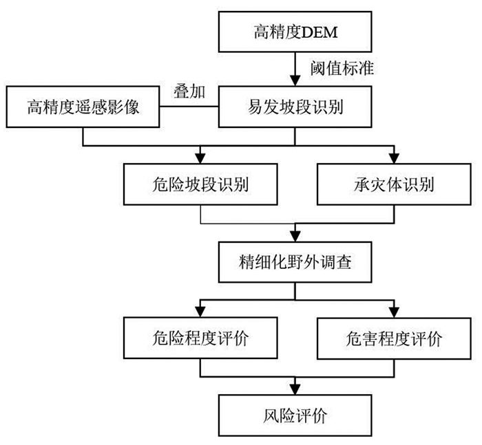
研究方法 本文以陕北黄土高原区米脂县为例,基于2 m×2 m精度DEM数据识别崩塌滑坡易发坡段,采用0.2 m分辨率遥感数据识别危险坡段,以自然村为单元实地调查危险坡段并评价其风险,通过递进的方式开展了黄土地质灾害隐患识别、调查和评价,构建了县域尺度黄土地质灾害精细化风险识别技术方法体系。
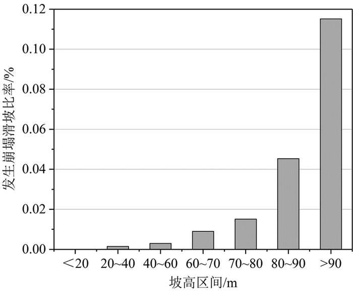
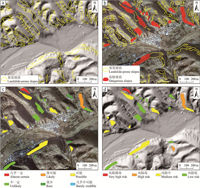
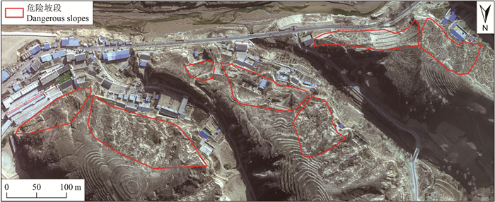
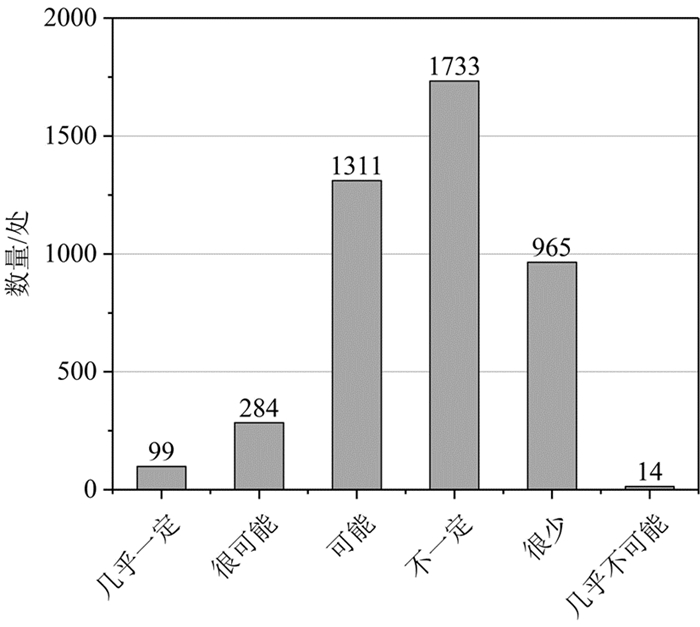
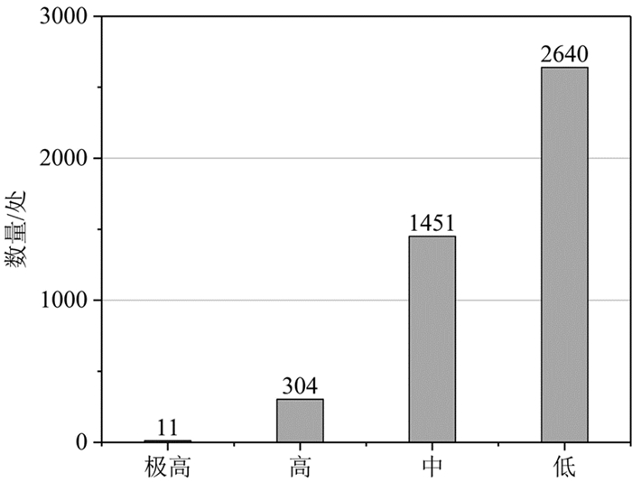
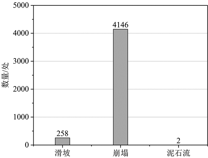
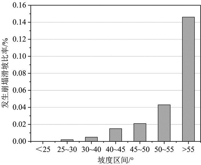
研究结果 结果表明:(1)米脂县共识别坡度大于40°、坡高大于20 m的崩塌滑坡易发坡段44716个,识别有威胁对象的危险坡段4198个;(2)通过风险识别、实地调查和评价,摸清了米脂县地质灾害隐患风险底数,米脂县共发育地质灾害风险点4406处,其中极高风险点11处、高风险点304处、中风险点1451处、低风险点2640处;(3)DEM和遥感识别风险点3880处,占风险点总数的88.06%,识别正确率92.42%;(4)2022年7—8月,米脂县人口居住区共有36处地质灾害风险点发生灾情或险情,全部位于本次风险识别范围之内,其中极高风险2处、高风险28处、中风险5处、低风险1处,极高风险点发生灾险情比例为18.18%,高风险点发生灾险情比例为9.21%,风险识别结果得到了有效验证。
结论 研究成果显著减轻了米脂县地质灾害造成的损失,为黄土地质灾害有效精准防控提供了科学依据。
Abstract:This paper is the result of geo-hazards survey engineering.
Objective The Loess Plateau is one of the regions with the most serious geo-hazards in China. The key to effectively and accurately prevent and control the loess geo-hazards is to precisely identify the hidden geo-hazards dangers and thoroughly understand the number of geo-hazards risks.
Methods This paper takes Mizhi County in the Loess Plateau region of northern Shaanxi as an example to perform the identification,investigation and evaluation of the hidden loess geo-hazards dangers step by step,and establish the system of refined risk identification technology method for the loess geo-hazards at the county level. The DEM data with resolution of 2 m×2 m is used to identify the slopes prone to induce collapses and landslides. The remote sensing data with resolution of 0.2 m is applied to identify the dangerous slopes. The natural village is taken as the unit to investigate the dangerous slopes and evaluate their risks.
Results The results show that: (1) A total of 44716 landslide-prone slopes with inclination degree greater than 40° and height larger than 20 m and 4198 dangerous slopes with threatening objects were identified. (2) Through risk identification,field investigation and evaluation,the total number of geo-hazard risks in Mizhi County was thoroughly understand. There are 4406 geo-hazards risks,including 11 extremely high risks,304 high risks,1451 medium risks and 2640 low risks. (3) A number of 3880 risks accounting for 88.06% of the total risks were identified by the DEM and remote sensing with the identification accuracy of 92.42%. (4) From July to August 2022,36 geo-hazards risks occurred,which are within the scope of this risk identification including 2 extremely high risks,28 high risks,5 medium risks and 1 low risk. The proportion of disasters located at extremely high risks is 18.18%,and the proportion of disasters occurred at high risks is 9.21%. The results of risk identification have been effectively verified.
Conclusions The research results significantly reduced the losses caused by geo-hazards in Mizhi County,and provided scientific references for effectively and accurately preventing and controlling the loess geo-hazards.
-
Key words:
- DEM /
- remote sensing /
- loess geo-hazards /
- refinement /
- risk identification /
- geo-hazards survey engineering /
- Mizhi County /
- Shaanxi Province
-

-
表 2 米脂县2022年7—8月强降雨诱发典型地质灾害一览
Table 2. Typical geological hazards induced by heavy rainfall in Mizhi county from July to August 2022

 下载: 导出CSV
-
Australian Geomechanics Society. 2000. Landslide risk management concepts and guidelines[J]. Australian Geomechanics, 35(1): 49-92.
Australian Geomechanics Society. 2007. Landslide risk management practice note[J]. Australian Geomechanics, 42(1): 64-114.
Bayer B, Simoni A, Schmidt D, Bertello L. 2017. Using advanced InSAR techniques to monitor landslide deformations induced by tunneling in the Northern Apennines, Italy[J]. Engineering Geology, 226: 20-32. doi: 10.1016/j.enggeo.2017.03.026
Feng L, Zhang M S, Jin Z, Zhang S S, Sun P P, Gu T F, Liu X B, Lin H, An Z S, Peng J B, Guo L. 2021. The genesis, development, and evolution of original vertical joints in loess[J]. Earth-Science Reviews, 214: 103526. doi: 10.1016/j.earscirev.2021.103526
Ge Daqing, Dai Keren, Guo Zhaocheng, Li Zhenhong. 2019. Early identification of serious geological hazards with integrated remote sensing technologies: Thoughts and recommendations[J]. Geomatics and Information Science of Wuhan University, 44(7): 949-956 (in Chinese with English abstract).
Li Shuangshuang, Kong Feng, Han Lu, Yan Junping, Wang Chengbo, Wu Yaqun. 2020. Spatiotemporal variability of extreme precipitation and influencing factors on the Loess Plateau in northern Shaanxi province[J]. Geographical Research, 39(1): 140-151 (in Chinese with English abstract).
Li Tonglu, Xi Yu, Hou Xiaokun. 2018. Mechanism of surface water infiltration induced deep loess landslide[J]. Journal of Engineering Geology, 26(5): 1113-1120 (in Chinese with English abstract).
Liu Chuanzheng, Chen Chunli. 2020. Achievements and countermeasures in risk reduction of geological disasters in China[J]. Journal of Engineering Geology, 28(2): 375-383 (in Chinese with English abstract).
Luo Li, Guo Wenzhao, Tian Pei, Liu Yili, Wang Shaokun, Luo Jiawei. 2023. Unique landslides (loess slide-flows) induced by an extreme rainstorm in 2018 on the Loess Plateau: A new geological hazard and erosion process[J]. International Journal of Sediment Research, 38(2): 228-239. doi: 10.1016/j.ijsrc.2022.07.009
Peng J B, Wang S K, Wang Q Y, Zhuang J Q, Huang W L, Zhu X H, Leng Y Q, Ma P H. 2019a. Distribution and genetic types of loess landslides in China[J]. Journal of Asian Earth Sciences, 170: 329-350. doi: 10.1016/j.jseaes.2018.11.015
Peng J B, Fan Z J, Wu D, Huang Q B, Wang Q Y, Zhuang J Q, Che W Y. 2019b. Landslides triggered by excavation in the loess plateau of China: A case study of Middle Pleistocene loess slopes[J]. Journal of Asian Earth Sciences, 171: 246-258. doi: 10.1016/j.jseaes.2018.11.014
Peng Jianbing, Lin Hongzhou, Wang Qiyao, Zhuang Jianqi, Cheng Yuxiang, Zhu Xinghua. 2014. The critical issues and creative concepts in mitigation research of loess geological hazards[J]. Journal of Engineering Geology, 22(4): 684-691 (in Chinese with English abstract).
Peng Jianbing, Wang Qiyao, Men Yuming, Xu Qiang, Zhuang Jianqi. 2019. Landslides at the Loess Plateau[M]. Beijing: Science Press (in Chinese).
Peng Jianbing, Wang Qiyao, Zhuang Jianqi, Leng Yanqiu, Fan Zhongjie, Wang Shaokai. 2020. Dynamic formation mechanism of landslide disaster on the Loess Plateau[J]. Journal of Geomechanics, 26 (5): 714-730 (in Chinese with English abstract).
Sun P, Wang H J, Wang G, Li R J, Zhang Z, Huo X T. 2021. Field model experiments and numerical analysis of rainfall-induced shallow loess landslides[J]. Engineering Geology, 295: 106411. doi: 10.1016/j.enggeo.2021.106411
Sun Pingping, Zhang Maosheng, Jia Jun, Cheng Xiujuan, Zhu Lifeng, Xue Qiang, Wang Jiayun. 2022. Geo-hazards research and investigation in the Loess Regions of Western China[J]. Northwestern Geology, 55(3): 96-107 (in Chinese with English abstract).
Wang Junhao, Wei Yunjie, Mei Aoshuang, Guan Jianjun, Ding Xiang, Wang Shuangting. 2021. Multidimensional extraction of UAV tilt photography-based information of loess landslide and its application[J]. Geology in China, 48(2): 388-401 (in Chinese with English abstract).
Xu Qiang, Dong Xiujun, Li Weile. 2019. Integrated space-air-ground early detection, monitoring and warning system for potential catastrophic geohazards[J]. Geomatics and Information Science of Wuhan University, 44(7): 957-966 (in Chinese with English abstract).
Xu Qiang. 2020. Understanding and consideration of related issues in early identification of potential geohazards[J]. Geomatics and Information Science of Wuhan University, 45(11): 1651-1659 (in Chinese with English abstract).
Xue Q, Zhang M S, Zhu L F, Cheng X J, Pei Y, Bi J B. 2014. Quantitative deformation analysis of landslides based on multi-period DEM data[C]. Landslide Science for a Safer Geoenvironment, 2: 201-207.
Xue Qiang, Zhang Maosheng. 2018. Monitoring, early warning and deformation characteristics of Yantu'an landslide in Yan'an[J]. Northwestern Geology, 51(2): 220-226 (in Chinese with English abstract).
Xue Qiang, Zhang Maosheng, Gao Bo, Zhang Jianlong. 2018. Risk assessment of geological hazards in Suide city, Shaanxi Province[J]. Journal of Engineering Geology, 26(3): 711-719 (in Chinese with English abstract).
Xue Qiang, Zhang Maosheng, Bi Junbo, Wang Xiaofei, Lin Longchao. 2019. Exfoliation erosion and deformation failure of excavated loess slope[J]. Northwestern Geology, 52(2): 158-166 (in Chinese with English abstract).
Xue Qiang, Zhang Maosheng, Gao Bo. 2020. Hazard assessment of loess landslide based on soil moisture content and supported by slope unit in Qingjian City, Shaanxi Province[J]. Geology in China, 47(6): 1904-1914 (in Chinese with English abstract).
Xue Qiang, Tang Yaming, Bai Xuan. 2021. Failure modes and risk control of geohazards in the county town of Daning in the Lüliang Mountains, China[J]. Mountain Research, 39(1): 151-162 (in Chinese with English abstract).
Yao Xin, Deng Jianhui, LIU Xinghong, Zhou Zhenkai, Yao Jiaming, Dai Fuchu, Ren Kaiyu, Li Lingjing. 2020. Primary recognition of active landslides and development rule analysis for pan Three-river-parallel Territory of Xizang Plateau[J]. Advanced Engineering Sciences, 52(5): 16-37 (in Chinese with English abstract).
Zhang Maosheng, Li Lin, Tang Yaming, Xue Qiang, Sun Pingping, Cheng Xiujuan. 2011. Risk management based landslide investigation and mapping in loess area[J]. Journal of Engineering Geology, 19(1): 43-51 (in Chinese with English abstract).
Zhang Maosheng, Hu Wei, Sun Pingping, Wang Xuelian. 2016. Advances and prospects of water sensitivity of loess and the induced loess landslides[J]. Journal of Earth Environment, 7(4): 323-334 (in Chinese with English abstract).
Zhang Maosheng, Xue Qiang, Jia Jun, Xu Jiwei. 2021. Theory, Method and Practice of Geological Hazard Risk Management[M]. Beijing: Science Press (in Chinese).
Zhang Qin, Zhao Chaoying, Chen Xuerong. 2022. Technical progress and development trend of geological hazards early identification with multi-source remote sensing[J]. Acta Geodaetica et Cartographica Sinica, 51(6): 885-896 (in Chinese with English abstract).
Zhang Y, Meng X M, Dijkstra T A, Jordan C J, Chen G, Zeng R Q, Novellino A. 2020. Forecasting the magnitude of potential landslides based on InSAR techniques[J]. Remote Sensing of Environment, 241: 111738. doi: 10.1016/j.rse.2020.111738
Zhang Yongshuang, Liu Xiaoyi, Yao Xin. 2020. InSAR-based method for early recognition of ancient landslide reactivation in Dadu River, China[J]. Journal of Hydraulic Engineering, 51(5): 545-555 (in Chinese with English abstract).
葛大庆, 戴可人, 郭兆成, 李振洪. 2019. 重大地质灾害隐患早期识别中综合遥感应用的思考与建议[J]. 武汉大学学报(信息科学版), 44(7): 949-956. https://www.cnki.com.cn/Article/CJFDTOTAL-WHCH201907001.htm
李双双, 孔锋, 韩鹭, 延军平, 汪成博, 武亚群. 2020. 陕北黄土高原区极端降水时空变化特征及其影响因素[J]. 地理研究, 39(1): 140-151. https://www.cnki.com.cn/Article/CJFDTOTAL-DLYJ202001013.htm
李同录, 习羽, 侯晓坤. 2018. 水致黄土深层滑坡灾变机理[J]. 工程地质学报, 26(5): 1113-1120. https://www.cnki.com.cn/Article/CJFDTOTAL-GCDZ201805001.htm
刘传正, 陈春利. 2020. 中国地质灾害防治成效与问题对策[J]. 工程地质学报, 28(2): 375-383. https://www.cnki.com.cn/Article/CJFDTOTAL-GCDZ202002018.htm
彭建兵, 林鸿州, 王启耀, 庄建琦, 成玉祥, 朱兴华. 2014. 黄土地质灾害研究中的关键问题与创新思路[J]. 工程地质学报, 22(4): 684-691. https://www.cnki.com.cn/Article/CJFDTOTAL-GCDZ201404018.htm
彭建兵, 王启耀, 门玉明, 许强, 庄建琦. 2019. 黄土高原滑坡灾害[M]. 北京: 科学出版社.
彭建兵, 王启耀, 庄建琦, 冷艳秋, 范仲杰, 王少凯. 2020. 黄土高原滑坡灾害形成动力学机制[J]. 地质力学学报, 26(5): 714-730. https://www.cnki.com.cn/Article/CJFDTOTAL-DZLX202005008.htm
孙萍萍, 张茂省, 贾俊, 程秀娟, 朱立峰, 薛强, 王佳运. 2022. 中国西部黄土区地质灾害调查研究进展[J]. 西北地质, 55(3): 96-107. https://www.cnki.com.cn/Article/CJFDTOTAL-XBDI202203007.htm
王俊豪, 魏云杰, 梅傲霜, 管建军, 丁祥, 王双亭. 2021. 基于无人机倾斜摄影的黄土滑坡信息多维提取与应用分析[J]. 中国地质, 48 (2): 388-401. http://geochina.cgs.gov.cn/geochina/article/abstract/20210204?st=search
许强, 董秀军, 李为乐. 2019. 基于天-空-地一体化的重大地质灾害隐患早期识别与监测预警[J]. 武汉大学学报(信息科学版), 44 (7): 957-966. https://www.cnki.com.cn/Article/CJFDTOTAL-WHCH201907002.htm
许强. 2020. 对地质灾害隐患早期识别相关问题的认识与思考[J]. 武汉大学学报(信息科学版), 45(11): 1651-1659. https://www.cnki.com.cn/Article/CJFDTOTAL-WHCH202011001.htm
薛强, 张茂省. 2018. 延安淹土安滑坡监测预警及变形特征[J]. 西北地质, 51(2): 220-226. https://www.cnki.com.cn/Article/CJFDTOTAL-XBDI201802029.htm
薛强, 张茂省, 高波, 张建龙. 2018. 陕西省绥德县城区地质灾害风险评估[J]. 工程地质学报, 26(3): 711-719. https://www.cnki.com.cn/Article/CJFDTOTAL-GCDZ201803018.htm
薛强, 张茂省, 毕俊擘, 王晓飞, 林隆超. 2019. 开挖型黄土边坡剥落侵蚀作用及变形破坏研究[J]. 西北地质, 52(2): 158-166. https://www.cnki.com.cn/Article/CJFDTOTAL-XBDI201902020.htm
薛强, 张茂省, 高波. 2020. 斜坡单元支持下基于土体含水率的陕西省清涧县城区黄土滑坡危险性评价[J]. 中国地质, 47(6): 1904-1914. http://geochina.cgs.gov.cn/geochina/article/abstract/20200624?st=search
薛强, 唐亚明, 白轩. 2021. 吕梁山区大宁县城地质灾害破坏模式及风险管控[J]. 山地学报, 39(1): 151-162. https://www.cnki.com.cn/Article/CJFDTOTAL-SDYA202101014.htm
姚鑫, 邓建辉, 刘星洪, 周振凯, 姚佳明, 戴福初, 任开瑀, 李凌婧. 2020. 青藏高原泛三江并流区活动性滑坡InSAR初步识别与发育规律分析[J]. 工程科学与技术, 52(5): 16-37. https://www.cnki.com.cn/Article/CJFDTOTAL-SCLH202005003.htm
张茂省, 李林, 唐亚明, 薛强, 孙萍萍, 程秀娟. 2011. 基于风险理念的黄土滑坡调查与编图研究[J]. 工程地质学报, 19(1): 43-51. https://www.cnki.com.cn/Article/CJFDTOTAL-GCDZ201101010.htm
张茂省, 胡炜, 孙萍萍, 王雪莲. 2016. 黄土水敏性及水致黄土滑坡研究现状与展望[J]. 地球环境学报, 7(4): 323-334. https://www.cnki.com.cn/Article/CJFDTOTAL-DQHJ201604001.htm
张茂省, 薛强, 贾俊, 徐继维. 2021. 地质灾害风险管理理论方法与实践[M]. 北京: 科学出版社.
张勤, 赵超英, 陈雪蓉. 2022. 多源遥感地质灾害早期识别技术进展与发展趋势[J]. 测绘学报, 51(6): 885-896. https://www.cnki.com.cn/Article/CJFDTOTAL-CHXB202206010.htm
张永双, 刘筱怡, 姚鑫. 2020. 基于InSAR技术的古滑坡复活早期识别方法研究——以大渡河流域为例[J]. 水利学报, 51(5): 545-555. https://www.cnki.com.cn/Article/CJFDTOTAL-SLXB202005005.htm
-


图(15)
表(2)
计量
- 文章访问数: 3062
- PDF下载数: 315
- 施引文献: 0