

Assessment of geological hazard susceptibility based on information method and ensemble learning algorithm: A case study of Harbin City in Heilongjiang Province
-
摘要:
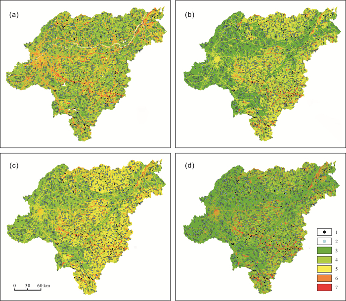
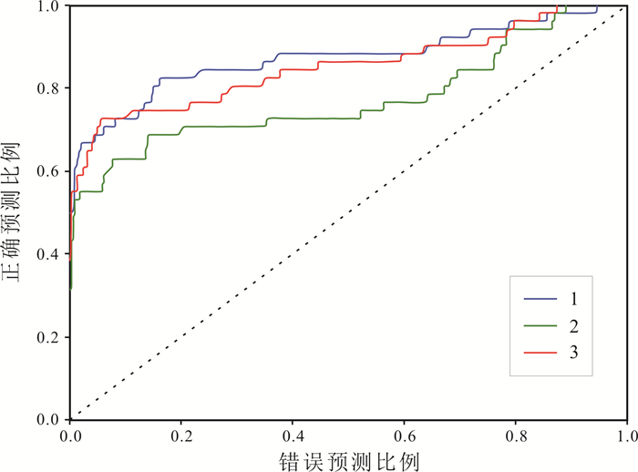
为开展黑龙江省哈尔滨市地质灾害易发性区划和地质灾害防治, 选取坡度、坡向、曲率、岩性、NDVI、距水系距离、距道路距离、距构造距离等8类评价因子, 建立地质灾害易发性评价指标体系.从信息量算法计算出的极低易发区和低易发区中随机选取非地质灾害样本, 与地质灾害样本组成论文数据集.采用随机森林、Adaboost和Stacking等3种集成学习方法对哈尔滨市地质灾害易发性进行评价, 并通过混淆矩阵进行精度验证.结果表明: 4种算法易发性评价分区图评价结果趋势相同, 且与研究区实际情况较为一致.哈尔滨市地质灾害主要诱发因素为人类工程活动, 极高发区主要集中在道路附近.随机森林算法预测的极高易发区的面积仅占全区的1.27%, 地质灾害数量占比21.03%, 频率比达16.58, AUC值为最高的0.891, 说明3种集成学习算法中, 随机森林算法在该区域地质灾害易发性评价中更具优势.
Abstract:To carry out the geological hazard susceptibility zoning and prevention in Harbin, Heilongjiang Province, eight evaluation factors including slope gradient, slope aspect, curvature, lithology, NDVI, distance from river, distance from road and distance from structure are selected to establish the evaluation index system of geological hazard susceptibility. The non-geological hazard samples are randomly chosen from the extremely low and low susceptible zones calculated by information algorithm, which forms the document data set together with the geological hazard samples. Besides, three ensemble learning methods such as random forest(RF), Adaboost and Stacking are used to assess the geological hazard vulnerability in Harbin, and the accuracy is verified by confusion matrix. The results show that the trend of evaluation results of the four algorithms is the same, and consistent with the actual situation of the study area. The major inducing factor of geological hazards in Harbin is human engineering activities, with the extremely high susceptible zones mainly concentrated near roads. The area of extremely high susceptible zones predicted by RF algorithm accounts for only 1.27% of the whole region, yet the number of geological hazards takes up 21.03%, with the frequency ratio of 16.58 and the maximum AUC value reaching 0.891, indicating that RF algorithm has more advantages in the geological hazard susceptibility evaluation among the above three algorithms.
-

-
表 1 影响因子间的相关系数
Table 1. Correlation coefficients of influencing factors
评价因子 高程 距水系距离 曲率 坡向 坡度 距道路距离 距构造距离 地层 NDVI 高程 1 距水系距离 -0.119 1 曲率 0.042 0 1 坡向 0.045 -0.005 0 1 坡度 0.605 -0.078 0.009 0.049 1 距道路距离 -0.159 0.005 0 -0.004 -0.012 1 距构造距离 0.092 -0.021 0.001 0.009 0.082 -0.024 1 地层 0.565 -0.101 0.009 0.038 0.049 -0.17 0.111 1 NDVI 0.357 -0.257 0 0.016 0.288 -0.136 0.073 0.362 1  下载: 导出CSV
表 2 地质灾害易发性评价指标信息量表
Table 2. Information value of geological hazard susceptibility assessment indexes
影响因素 二类评价因子 信息量值 排序 影响因素 二类评价因子 信息量值 排序 坡度/(°) 0~3 -0.525 33 NDVI 0~0.51 -0.811 38 3~6 -0.185 29 0.51~0.73 0.726 11 6~10 0.387 18 0.73~0.82 0.431 16 10~16 0.724 12 0.82~0.87 0.443 15 16~90 -0.116 27 >0.87 -0.801 37 坡向/(°) 0~73 -0.607 34 距水系距离/m 0~100 0.107 23 73~146 -0.068 26 100~200 1.740 2 146~212 0.765 9 200~300 0.764 10 212~270 0.329 21 300~400 -0.242 30 270~360 -0.611 35 >400 -0.026 24 曲率 <-0.78 1.049 6 距道路距离/m 0~100 2.734 1 -0.78~-0.33 0.386 19 100~300 1.434 3 -0.33~0 -0.172 28 300~500 0.367 20 0~0.33 -0.495 31 500~700 0.675 14 >0.33 0.869 7 >700 -0.834 39 岩性 第四系 -0.645 36 距构造距离/m 0~100 -1.049 40 沉积岩 0.696 13 100~300 -0.497 32 喷出岩 0.787 8 300~500 0.213 22 侵入岩 0.410 17 500~800 1.346 4 变质岩 1.295 5 >800 -0.037 25
下载: 导出CSV
表 3 基于不同算法的易发性分区结果
Table 3. Susceptibility zoning results based on different algorithms
评估算法 危险等级 栅格单元数据量 栅格单元面积比例/% 地质灾害数量 地质灾害数量占比/% 频率比 信息量 极低易发 18604798 31.92 15 7.01 0.22 低易发 21629659 37.11 37 17.29 0.47 中易发 11344966 19.46 53 24.77 1.27 高易发 4931899 8.46 46 21.50 2.54 极高易发 1773834 3.04 63 29.44 9.67 随机森林 极低易发 2434647 45.75 31 14.49 0.32 低易发 1378756 25.91 33 15.42 0.60 中易发 1102540 20.72 45 21.03 1.02 高易发 338744 6.36 60 28.04 4.41 极高易发 67501 1.27 45 21.03 16.58 Adaboost 极低易发 446386 8.39 4 1.87 0.22 低易发 2493305 46.85 49 22.90 0.49 中易发 1797451 33.77 72 33.64 1.00 高易发 515218 9.68 55 25.70 2.65 极高易发 69828 1.31 34 15.89 12.11 Stacking 极低易发 3171461 59.59 45 21.03 0.35 低易发 663386 12.46 23 10.75 0.86 中易发 319539 6.00 13 6.07 1.01 高易发 421394 7.92 24 11.21 1.42 极高易发 746408 14.02 109 50.93 3.63
下载: 导出CSV
表 4 算法预测性能结果
Table 4. Prediction performance results of different algorithms
算法 准确率 精度 AUC F1 随机森林 0.941 0.893 0.891 0.633 Adaboost 0.923 0.683 0.742 0.609 Stacking 0.953 0.938 0.855 0.723
下载: 导出CSV
-
[1] 杨锐, 于春勇, 汪洋. 基于加权信息量和GIS方法的地质灾害易发性评价--以榆社县为例[J]. 矿业研究与开发, 2023, 43(2): 163-170.
Yang R, Yu C Y, Wang Y. Susceptibility evaluation of geological disaster based on weighted information and GIS method: A case study of Yushe County[J]. Mining Research and Development, 2023, 43(2): 163-170.
[2] 窦杰, 向子林, 许强, 等. 机器学习在滑坡智能防灾减灾中的应用与发展趋势[J]. 地球科学, 2023, 48(5): 1657-1674.
Dou J, Xiang Z L, Xu Q, et al. Application and development trend of machine learning in landslide intelligent disaster prevention and mitigation[J]. Earth Science, 2023, 48(5): 1657-1674.
[3] 莫运松, 江思义, 邹仁辉, 等. 基于专家-层次分析法的地质灾害风险性评价--以广西富川瑶族自治县为例[J]. 矿产勘查, 2023, 14(2): 293-303.
Mo Y S, Jiang S Y, Zou R H, et al. Risk assessment of geological disasters based on expert-analytic hierarchy process: A case study of Fuchuan Yao Autonomous County in Guangxi[J]. Mineral Exploration, 2023, 14(2): 293-303.
[4] Zhu X G, Yan R. Risk assessment of geological hazards in the Dahe Mountain area based on AHP[J]. DEStech Transactions on Environment Energy and Earth Science, 2019. DOI: 10.12783/dteees/gmee2018/27463.
[5] 毛正君, 张瑾鸽, 仲佳鑫, 等. 基于确定性系数法的梯田型黄土滑坡隐患影响因素分析[J]. 水土保持通报, 2023, 43(2): 183-192, 340.
Mao Z J, Zhang J G, Zhong J X, et al. Sensitivity analysis on factors influencing loess terrace landslide potential using certainty factor method[J]. Bulletin of Soil and Water Conservation, 2023, 43(2): 183-192, 340.
[6] Ma J R, Wang X D, Yuan G X. Evaluation of geological hazard susceptibility based on the regional division information value method[J]. ISPRS International Journal of Geo-Information, 2023, 12(1): 17. doi: 10.3390/ijgi12010017
[7] 宋渊, 江南, 张恩博, 等. 基于证据权法的湖北省兴山县滑坡灾害易发性评价[J]. 地质与资源, 2023, 32(3): 352-359, 289. DOI: 10.13686/j.cnki.dzyzy.2023.03.012.
Song Y, Jiang N, Zhang E B, et al. Susceptibility evaluation of landslide hazard in Xingshan County of Hubei Province based on weights-of-evidence method[J]. Geology and Resources, 2023, 32(3): 352-359, 289. DOI: 10.13686/j.cnki.dzyzy.2023.03.012.
[8] Agrawal N, Dixit J. GIS-based landslide susceptibility mapping of the Meghalaya-Shillong Plateau region using machine learning algorithms[J]. Bulletin of Engineering Geology and the Environment, 2023, 82(5): 170. doi: 10.1007/s10064-023-03188-2
[9] 张文龙, 张振凯, 杨帅. 勉略宁地区地质灾害危险性智能评价和区划研究[J]. 西北地质, 2023, 56(1): 276-283.
Zhang W L, Zhang Z K, Yang S. Study on intelligent evaluation and zoning of geohazards risk in Mianluening area[J]. Northwestern Geology, 2023, 56(1): 276-283.
[10] 刘海知, 徐辉, 包红军, 等. 机器学习分类算法在降雨型滑坡预报中的应用[J]. 应用气象学报, 2022, 33(3): 282-292.
Liu H Z, Xu H, Bao H J, et al. Application of machine learning classification algorithm to precipitation-induced landslides forecasting[J]. Journal of Applied Meteorological Science, 2022, 33(3): 282- 292.
[11] Wang J Q, Sun P F, Chen L L, et al. Recent advances of deep learning in geological hazard forecasting[J]. Computer Modeling in Engineering & Sciences, 2023, 137(2): 1381-1418.
[12] Fang Z C, Wang Y, Peng L, et al. A comparative study of heterogeneous ensemble-learning techniques for landslide susceptibility mapping[J]. International Journal of Geographical Information Science, 2021, 35(2): 321-347. doi: 10.1080/13658816.2020.1808897
[13] 茹曼, 郑燕, 张斌, 等. 基于SVM-RF模型的地质灾害易发性评价--以河南省博爱县青天河景区为例[J]. 地质与资源, 2023, 32(5): 633-641. DOI: 10.13686/j.cnki.dzyzy.2023.05.014.
Ru M, Zheng Y, Zhang B, et al. Assessment of geological disaster susceptibility based on SVM-RF model: A case study of Qingtian River scenic area in Boai County, Henan Province[J]. Geology and Resources, 2023, 32(5): 633-641. DOI: 10.13686/j.cnki.dzyzy.2023.05.014.
[14] 徐继伟, 杨云. 集成学习方法: 研究综述[J]. 云南大学学报(自然科学版), 2018, 40(6): 1082-1092.
Xu J W, Yang Y. A survey of ensemble learning approaches[J]. Journal of Yunnan University, 2018, 40(6): 1082-1092.
[15] 虞瑶, 高涵, 陶旸, 等. 基于集成学习的高光谱遥感影像分类综述[J]. 测绘与空间地理信息, 2023, 46(4): 49-52, 60. doi: 10.3969/j.issn.1672-5867.2023.04.014
Yu Y, Gao H, Tao Y, et al. A review of hyperspectral remote sensing image classification based on ensemble learning[J]. Geomatics & Spatial Information Technology, 2023, 46(4): 49-52, 60. doi: 10.3969/j.issn.1672-5867.2023.04.014
[16] 苏彬. 黑龙江省哈尔滨市区地质灾害研究[D]. 长春: 吉林大学, 2014.
Su B. Research on geological hazard in Harbin city of Heilongjiang province[D]. Changchun: Jilin University, 2014.
[17] 王佳佳, 殷坤龙, 肖莉丽. 基于GIS和信息量的滑坡灾害易发性评价--以三峡库区万州区为例[J]. 岩石力学与工程学报, 2014, 33(4): 797-808.
Wang J J, Yin K L, Xiao L L. Landslide susceptibility assessment based on GIS and weighted information value: A case study of Wanzhou District, Three Gorges reservoir[J]. Chinese Journal of Rock Mechanics and Engineering, 2014, 33(4): 797-808.
[18] Ling X, Zhu Y Q, Ming D P, et al. Feature engineering of geohazard susceptibility analysis based on the random forest algorithm: Taking Tianshui City, Gansu Province, as an example[J]. Remote Sensing, 2022, 14(22): 5658. doi: 10.3390/rs14225658
[19] Ramineni V, Surekha Y, Kumar A V. Machine learning based Adboost algorithms[J]. International Journal of Recent Technology and Engineering (IJRTE), 2019, 7(6S5): 1928-1932.
[20] 郭亚雷, 邓念东, 李宇新, 等. 基于堆叠模型的滑坡易发性评价--以商洛市丹凤县为例[J]. 自然灾害学报, 2023, 32(2): 243-252.
Guo Y L, Deng N D, Li Y X, et al. Evaluation of landslide susceptibility based on Stacking: Take Danfeng County, Shangluo City as an example[J]. Journal of Natural Disasters, 2023, 32(2): 243-252.
[21] Ting K M, Witten I H. Issues in stacked generalization[J]. Journal of Artificial Intelligence Research, 1999, 10(1): 271-289.
[22] Shirzadi A, Bui D T, Pham B T, et al. Shallow landslide susceptibility assessment using a novel hybrid intelligence approach[J]. Environmental Earth Sciences, 2017, 76(2): 60. doi: 10.1007/s12665-016-6374-y
[23] 周侯伯, 肖桂荣, 林炫歆, 等. 基于特征筛选与差分进化算法优化的滑坡危险性评估方法[J]. 地球信息科学学报, 2022, 24(12): 2373-2388. doi: 10.12082/dqxxkx.2022.220158
Zhou H B, Xiao G R, Lin X X, et al. Landslide hazard assessment method based on feature screening and differential evolution algorithm optimization[J]. Journal of Geo-information Science, 2022, 24(12): 2373-2388. doi: 10.12082/dqxxkx.2022.220158
[24] 孔嘉旭, 庄建琦, 彭建兵, 等. 基于信息量和卷积神经网络的黄土高原滑坡易发性评价[J]. 地球科学, 2023, 48(5): 1711-1729.
Kong J X, Zhuang J Q, Peng J B, et al. Evaluation of landslide susceptibility in Chinese Loess Plateau based on Ⅳ-RF and Ⅳ-CNN coupling models[J]. Earth Science, 2023, 48(5): 1711-1729.
[25] 戴梦兰, 陈志波, 施国栋. 基于分形理论的浙江省地质灾害分布特征与影响因素分析[J]. 中国地质灾害与防治学报, 2022, 33(6): 63-69.
Dai M L, Chen Z B, Shi G D. Analysis of the distribution characteristics and influencing factors of geological hazards in Zhejiang Province based on fractal theory[J]. The Chinese Journal of Geological Hazard and Control, 2022, 33(6): 63-69.
[26] Wu X Y, Song Y B, Chen W, et al. Analysis of geological hazard susceptibility of landslides in Muli County based on random forest algorithm[J]. Sustainability, 2023, 15(5): 4328. doi: 10.3390/su15054328
[27] 左群超, 叶天竺, 冯艳芳, 等. 中国陆域1: 25万分幅建造构造图空间数据库(Ⅴ1)[EB/OL]. 中国地质调查局发展研究中心[创建机构], 2006.
http://dcc.ngac.org.cn/geologicalData/rest/geologicalData/geologicalDataDetail/8adaeff963f2eb2a0163f335b7600019. Zuo Q C, Ye T Z, Feng Y F, et al. Spatial data base of serial suite- tectonic map-sheets of mainland China (1: 250000)[EB/OL]. Geology in China. 2018. 45(S1): 1-26. (in Chinese)
[28] 董金玮, 周岩, 尤南山, 等. 2000-2022年中国30米年最大NDVI数据集[DB/OL]. 国家生态科学数据中心, 2021.
https://doi.org/10.12199/nesdc.ecodb.rs.2021.012. .Dong J W, Zhou Y, You N S, et al. Divergent shifts in peak photosynthesis timing of temperate and alpine grasslands in China[DB/OL]. Remote Sensing of Environment, 2021.
https://www.nesdc.org.cn/sdo/detail?id=60f68d757e28174f0e7d8d49. (in Chinese)[29] Shahabi H, Hashim M, Ahmad B B. Correction to: Remote sensing and GIS-based landslide susceptibility mapping using frequency ratio, logistic regression, and fuzzy logic methods at the central Zab basin, Iran[J]. Environmental Earth Sciences, 2023, 82(11): 281. doi: 10.1007/s12665-023-10941-z
[30] 杨硕, 李德营, 严亮轩, 等. 基于随机森林模型的乌江高陡岸坡滑坡地质灾害易发性评价[J]. 安全与环境工程, 2021, 28(4): 131- 138.
Yang S, Li D Y, Yan L X, et al. Landslide susceptibility assessment in high and steep bank slopes along Wujiang River based on random forest model[J]. Safety and Environmental Engineering, 2021, 28(4): 131-138.
-

图(4)
表(4)
计量
- 文章访问数: 56
- PDF下载数: 33
- 施引文献: 0