冶金渣胶凝材料对镉离子的固化性能研究

崔孝炜, 邓惋心, 谢宇轩, 王乐. 冶金渣胶凝材料对镉离子的固化性能研究[J]. 矿产保护与利用, 2021, 41(1): 15-19. doi: 10.13779/j.cnki.issn1001-0076.2021.01.002
引用本文: 崔孝炜, 邓惋心, 谢宇轩, 王乐. 冶金渣胶凝材料对镉离子的固化性能研究[J]. 矿产保护与利用, 2021, 41(1): 15-19. doi: 10.13779/j.cnki.issn1001-0076.2021.01.002
CUI Xiaowei, DENG Wanxin, XIE Yuxuan, WANG Le. Study on the Stabilization of Cd2+ by Cementitious Materials Prepared with Metallurgical Slag[J]. Conservation and Utilization of Mineral Resources, 2021, 41(1): 15-19. doi: 10.13779/j.cnki.issn1001-0076.2021.01.002
Citation: CUI Xiaowei, DENG Wanxin, XIE Yuxuan, WANG Le. Study on the Stabilization of Cd2+ by Cementitious Materials Prepared with Metallurgical Slag[J]. Conservation and Utilization of Mineral Resources, 2021, 41(1): 15-19. doi: 10.13779/j.cnki.issn1001-0076.2021.01.002

冶金渣胶凝材料对镉离子的固化性能研究

  • 基金项目:
    陕西省高层次人才特殊支持计划项目;国家大学生创新创业训练计划项目(201911396003);商洛市科技计划项目(SK2018-03-02);商洛学院自然科学研究项目(17SKY026)
详细信息
    作者简介: 崔孝炜(1988-), 男, 陕西商洛人, 博士, 副教授, 主要从事固废资源化利用研究, E-mail: slcui320@slxy.edu.cn
  • 中图分类号: X751

Study on the Stabilization of Cd2+ by Cementitious Materials Prepared with Metallurgical Slag

  • 以钢渣、矿渣和脱硫石膏为原料制备胶凝材料,研究了其对镉离子的固化效果。研究结果表明:在Cd2+浓度不高于30 mg/kg时,胶凝材料对镉离子吸附效果较好,主要是因为镉离子能够以"类质同象"的方式替代Ca2+进入钙矾石(AFt)的晶格和Friedel盐,形成含镉复盐而被固化,再加上C-S-H对镉的吸附作用,共同促使Cd2+被高效固化。研究结果对于含镉废水的治理具有重要意义。

  • 兴蒙造山带记录了古亚洲洋俯冲、西伯利亚和华北板块碰撞拼合等大量重要信息(Xiao W J et al., 2003; Jian P et al., 2008; Xu B et al., 2015), 其构造演化过程与古亚洲洋的构造运动密切相关(Windley B F et al., 2007; Han B F et al., 2011; Xu Z et al., 2012; Zhang X H et al., 2012; 王树庆等, 2019; 赵越等, 2010)。俯冲增生造山与地体拼贴过程造就了兴蒙造山带现有格架(Coleman R G, 1989; Windley B F et al., 1990; Allen M B et al., 1993, 1995; Sengor A M C et al., 1993; Gao J.et al, 1998; Jahn B M et al., 2000; Windley B F et al., 2007; Xiao W J et al., 2004, 2010; Li Y J et al., 2018, 2020; Yuan Y et al., 2018; 赵磊等, 2019; 赵闯等, 2020)。正确认识兴蒙造山带的演化对于恢复中亚造山带地区的构造历史意义重大。近些年围绕华北板块北缘重要地质问题进行了大量科学研究, 获得了丰富的资料(吴飞等, 2014; 张维等, 2012; Zhang W et al., 2013; Liu M et al., 2016)。目前多数学者认为古亚洲洋在早古生代经历了南北两侧的双向俯冲(Xu B et al., 2013; Li Y L et al., 2014; Liu Y J et al., 2017), 并形成了相应的2条早古生代岛弧俯冲带(Jian P et al., 2008)。其中南部俯冲带就位于巴特敖包—白乃庙—温都尔庙地区, 其存在较为完整的俯冲记录, 包含温都尔庙俯冲增生杂岩带和白乃庙岛弧岩浆岩带。

    内蒙古北柳图庙幅1∶50 000地质图幅区位于华北板块北缘以北的南部俯冲带形成的白乃庙岛弧岩浆岩带之上(图 1)。本区最早于1976年由内蒙古自治区地质局区域地质测量队开展了1∶200 000镶黄旗幅区域地质测量A, 并对区内的地层格架、岩浆活动、构造演化等方面做了全面、系统的总结。2008年, 内蒙古地质矿产勘察院完成了内蒙古自治区锡林郭勒盟太古生庙等4幅1∶50 000地质矿产调查B。2012年, 中化地质矿山总局内蒙古地质勘查院完成了内蒙古乌兰察布市土木尔台地区4幅1∶50 000区域矿产地质调查C, 内蒙古自治区地质调查院完成了内蒙古查干哈达庙—别鲁乌图地区矿产远景调查D。此外, 近些年围绕温都尔庙造山带古生界演化, 进行了大量科学研究并积累了丰富的资料(柳长峰等, 2014; 李俊建等, 2015; 钱筱嫣等, 2017)。这些调查研究为北柳图庙幅地质图的编制奠定了扎实基础。

    图 1.  内蒙古北柳图庙幅(K49E011021)大地构造位置图(据Xiao WJ et al., 2003修改)

    北柳图庙幅1∶50 000地质图作为智能化区域地质调查填图试点的的探索性图件, 力争在客观表达野外地质事实的基础上, 结合前人地质调查、矿产勘查以及科研新成果, 采用最新的填图思路及智能化地质填图方法, 综合造山带构造解析手段(白瑾, 2003), 精细刻画白乃庙岛弧带的早古生代地质构造演化过程。内蒙古北柳图庙幅1∶50 000地质图数据库(表 1刘洋等, 2020)系统反映了白乃庙古生代地质体的沉积建造、构造组合样式与时代属性, 从而为温都尔庙地区地质科研和野外地质调查提供有益的参考资料。

    表 1.  数据库(集)元数据简介
    条目 描述
    数据库(集)名称 内蒙北柳图庙幅1∶50 000地质图数据库
    数据库(集)作者 沉积岩类: 刘 洋, 中国地质调查局天津地质调查中心
    火山岩类: 滕 飞, 中国地质调查局天津地质调查中心
    岩浆岩类: 王文龙, 中国地质调查局天津地质调查中心
    变质岩类: 杨泽黎, 中国地质调查局天津地质调查中心
    数据时间范围 2016—2018年
    地理区域 经纬度: 东经113°00′~113°30′; 北纬42°00′~42°20′
    数据格式 MapGIS
    数据量 28.9 MB
    数据服务系统网址 http://dcc.cgs.gov.cn
    基金项目 中国地质调查局地质调查项目“内蒙古温都尔庙-镶黄旗地区区域地质调查” (项目编号: DD20190038)
    语种 中文
    数据库(集)组成 北柳图庙幅1∶50 000地质图数据库包括: 1∶50 000地质图库、角图和图饰。地质图库包括沉积岩、火山岩、侵入岩、第四系、构造形迹、地质界线、产状、矿化(点)、蚀变、岩性花纹、各类代号等。角图包括综合柱状图、侵入岩填图单位、图切剖面、大地构造位置图。图饰包括接图表、图例、责任表等
     | Show Table
    DownLoad: CSV

    内蒙古北柳图庙幅1∶50 000地质图以《1∶50 000区域地质调查技术要求》(DD 2019–01)为规范, 在参考1∶50 000矿产地质调查项目原始资料(包括地质草图、遥感解译影像)的基础上, 根据项目野外实际资料(实际材料图、剖面图)重新连图而成, 代表北柳图庙幅1∶50 000最新地质填图新成果。地理底图采用国家测绘地理信息局最新地理数据。应用已有的技术标准和数字填图系统(DGSS)、MapGIS等计算机软件进行数据处理。

    预研究数据库主要包括各类遥感影像、卫星影像、物化探图件, 各类图件经核查可用后, 校正配准套在1∶50 000标准图框及数字地形中, 形成野外工作底图投影系统为高斯–克吕格投影参数, 坐标系统为2000国家大地坐标系(CGCS 2000)。进一步结合1∶200 000地质图、1∶50 000矿产地质图, 编制地质草图, 所有子图号、岩石代号均按照《1∶50 000区域地质图图例》(GB 958−99)进行标准化, 在此基础上编制工作部署图, 参考内蒙古岩石地层清理及前人研究成果, 初步划分野外填图单位, 并编制数字填图字典库, 供野外地质调查参考使用。

    根据已有资料的综合分析和地质草图的编制, 划分重点工作区和一般工作区, 确定了重点填图内容为白乃庙岛弧带火山岩及岩浆岩, 并对复杂区进行了路线加密。原始数据库整体又可分为数字填图资料和数字剖面库。

    数字填图资料以1∶25 000底图为基础, 通过野外实际路线调查, 在数字填图系统中采集地质点和地质界线及路线等点、线信息, 观察并录入各点的性质、岩性、产状等信息, 形成野外手图。野外手图库存储野外地质路线各类地质数据, 是最重要的野外第一手原始资料数据库。在野外手图库检查无误的基础上, 对所有地质路线内容进行入库汇总整合, 形成野外PRB总图库。并将实体观测数据点、线采集层及标注图层进一步继承到实际材料图库中。一般来说, 野外手图整理按照以下步骤进行:

    (1)野外手图的规范处理: 将野外采集的手图资料导入电脑, 补充、完善细化地质点(P)、点间路线(R)、界线(B)、产状、采样、照片对话框与属性框中各项内容, 并保持整体协调一致, 确保客观描述信息无误。

    (2)野外手图的整饰处理: 结合地形、遥感资料, 按“V”字形法则勾绘界线, 对于U型路线, 必须确保两侧界线相互对应, 在此基础上, 按照规范要求的线型、子图号及颜色进行处理, 整饰圆滑, 并在点间增加岩性标注信息, 便于后续连图。

    (3)野外手图的综合整理: 结合目标任务, 进行野外路线小结, 系统梳理地层、岩浆岩及构造信息, 对接触关系、构造变形等重要地质现象要专门处理, 整体数据质量检查及自检无误, 提交项目负责入库连图。

    数字剖面库采用数字剖面测量方式进行, 以野外工作手图为底图, 在充分踏勘的基础上, 选择出露完整地段进行。野外逐层分层进行, 记录岩性、样品、产状、照片、构造变形等信息, 并在野簿上相应做信手剖面图, 均按系统自动生成的文件名及根据需要自定义文件名进行存储。一般在测量完整剖面后, 由剖面的记录者进行剖面的初步整理和野外小结, 结合室内薄片鉴定, 画剖面图及剖面柱状图。

    实际材料图是用点、线、面的空间实体在地形图上表示地质点、地质界线、分段路线、地质体、样品、产状、GPS点等各种地质要素分布密度的一种重要的原始资料地质图件。1∶50 000区域地质调查包括实际材料图在内的原始资料原则要求用1∶25 000比例尺图幅。一般来说, 野外手图整理按照以下步骤进行:

    (1)地质体界线的形成。实际材料图库中用于连图的线图层文件名为Geoline.wl, 为建立拓扑关系, 形成地质体面, 其内容除地质体界线外, 还包括内图框线及面状水体、雪山、沙漠等界线, 其中后者从相关图层直接拷贝获取。注: 不分割地质体面的整饰界线不归入Geoline.wl图层, 如部分岩相界线、未经证实的遥感解译断层、变质相带等。

    (2)地质体面的形成。地质体界线形成后通过拓扑可形成地质体面实体, 主要通过地质体线转弧段, 进行拓扑重建并进行错误检查, 新生成的临时区文件没有属性结构, 将其合并至实际材料图库地质体区文件中。

    (3)地质体赋属性。数字实际材料图线、面文件形成并赋予属性结构后, 必须对其属性内容进行补充完善。主要包括: 地质体界线属性提取, 地质体面实体属性提取, 根据地质体面自动给界线赋左右地质体代号, 浏览编辑实际材料图属性等步骤。

    (4)实际材料图的整理。主要包括对不同地质体根据属性进行统一着色, 根据相关标准规范对地质体不同类型界线线型及对应参数进行修改, 按规范对地质体代号进行标注, 对图廓外进行整饰, 重点是图例的完善, 将实际材料图库中系统自动生成的无用的空文件删除。

    编稿原图等同于地质图, 1∶50 000编稿原图是在1∶25 000实际材料图基础上形成。在形成编稿原图后需要进行全面性、规范性、标准化整理。具体包括: 地质体界线图层、地质体面图层、产状图层、地质图整饰图层、地质体标注、图外整饰图层、编稿原图库文件等图层及文件的整理流程。在编稿原图库中将系统自动生成的无内容的空文件删除, 在编稿原图工程文件中将野外地质采集图层文件删除, 仅保留与地质图相关的图层文件。

    空间数据库包括基本要素类、综合要素类、对象类和独立要素类数据库。其中要素数据库是共享空间参考系统的要素类的集合, 在地质图数据模型中, 由地质点、面、线实体类构成。对象类是一个表, 存储非空间数据, 在地质图数据模型中, 一般一个要素类对应多个对象类。地质图基本要素类、综合要素类和对象类各数据项属性齐全。

    成果数据库建设内容和有关要求将依据《数字地质图图层及属性文件格式》(D/Z 0197−1997)等标准进行图形库和属性库等的建设, 参照《地质图用色标准及用色原则》(DZ/T 0179−1997)、《区域地质图图例》(GB 958−99)等标准确定用色及图饰、图例、符号等的表达。

    内蒙古北柳图庙幅(K49E011021)1∶50 000地质图主要角图包括: 综合地层柱状图、侵入岩填图单位、图切剖面、大地构造位置图和其他角图(图 2)。

    图 2.  内蒙古北柳图庙幅(K49E011021)1∶50 000地质图示意图

    (1)综合地层柱状图: 对不同的岩石地层单元沉积建造特征进行详细表达。系统梳理图幅内各地层单元地层层序、岩石组合特征, 结合锆石测年资料, 综合反映其沉积背景及时代属性。

    (2)侵入岩填图单位: 识别出4期岩浆演化序列: ①晚寒武世以发育片麻理的灰白色细粒含石榴白云母花岗岩为代表的俯冲期岩石(约500 Ma); ②晚志留世以中粗粒、中粒、中细粒英云闪长岩(425 Ma)和中粒、中细粒斑状英云闪长岩(423 Ma)为主, 代表了早古生代岛弧构造背景的岩石组合; ③中二叠世早期以中细粒石英闪长岩、中细粒花岗岩闪长岩为主(约268 Ma), 代表中二叠世早期挤压构造背景; ④中二叠世晚期以二长花岗岩(中粒、中细粒)为主(约263 Ma), 代表着构造背景由挤压向伸展构造体制的转换。

    (3)图切剖面: 图幅内建造和构造的总体走向为近北西—北西西向, 为直观表达区内各地质体接触关系及空间位态, 共布置2条图切剖面, 对本图幅内各地质体之接触关系进行了较全面控制: ①早古生代岛弧火山岩大比例尺剖面, 结合大比例尺的构造解析, 详细反映了早古生代岛弧带物质组成及构造序列特征; ②北西向纵贯全区剖面, 主要控制整个古生代花岗岩等地质体的空间位态。

    (4)大地构造位置图: 表达了北柳图庙幅在区域大地构造中所处的位置及其大地构造单元划分情况。大地构造位置图体现了温都尔庙洋早古生代向南俯冲形成的沟-弧-盆体系及工作区所处的构造位置。

    (5)其他角图: 对脉岩、地质代号、地质符号及岩性花纹进行梳理, 编制图例及责任表。

    地质面.wp, 地质线.wl, 地质点.wt。

    主图内容包括沉积岩、火山岩、侵入岩、第四系、构造形迹、地质界线、产状、各类代号等。

    角图内容包括地层综合柱状图、侵入岩填图单位、图切剖面、大地构造位置图等。

    图饰内容包括接图表、图例、责任表等。

    实体类型名称: 点、线、面。

    点实体: 各类地质体符号及标记、地质花纹、矿化蚀变。

    线实体: 断裂构造、地质界线、岩相界线、构造界线及特殊标志层花纹等。

    面实体: 沉积岩、火山岩、变质岩、侵入岩、第四系等。

    北柳图庙幅(K49E011021)1∶50 000地质图数据库包含地质实体要素信息、地理要素信息和地质图整饰要素信息。地理要素信息属性沿用国家测绘地理信息局提供的数据属性结构。地质实体要素信息属性按照1∶50 000区域地质调查专项地质填图数据库建库要求分4大岩类(沉积岩、火山岩、侵入岩、变质岩)、断裂构造、产状要素、矿产地等分别建立数据库属性。

    沉积岩建造数据属性主要有: 年代地层单位、岩石地层单位、建造名称、建造代码、岩性组合、地层时代、建造厚度、建造含矿性、岩石结构、沉积构造、岩石颜色、沉积作用类型、沉积相类型、同沉积构造。

    火山岩建造数据属性主要有: 年代地层单位、岩石地层单位、建造名称、建造代码、地层时代、地层分区、岩性组合、建造厚度、建造含矿性、火山喷发旋回、火山喷发类型、火山岩成因类型、特殊岩性夹层、火山岩相类型、同位素年龄。

    侵入岩建造数据属性主要有: 建造名称、建造代码、岩性组合、建造含矿性、岩石结构、岩石构造、侵入期次、岩体产状、平面形态、剖面形态、岩体侵位构造特征、接触带特征、成因类型、同位素年龄。

    变质岩建造数据属性主要有: 年代地层单位、岩石地层单位、建造名称、建造代码、岩性组合、地层时代、建造厚度、建造含矿性、岩石结构、岩石构造、原岩建造、变质相、变质作用类型。

    断裂构造数据属性主要有: 断裂名称、断裂类型、断裂延长、断裂延深、断裂宽度、断裂走向、断裂面倾向、断裂面倾角、断距、断裂面形态、构造岩特征、运动方式、活动期次、力学性质。

    产状数据属性有: 产状类型、倾向、倾角。

    地质图基本要素类、综合要素类和对象类各数据项属性列表见表 2

    表 2.  地质图空间数据库数据属性表
    数据类型 名称 标准编码 数据项属性
    基本要素类 地质体面实体 _GeoPolygon 地质体面实体标识号, 地质体面实体类型代码, 地质体面实体名称, 地质体面实体时代, 地质体面实体下限年龄值, 地质体面实体上限年龄值, 子类型标识
    地质(界)线 _GeoLine 要素标识号, 地质界线代码, 地质界线类型, 界线左侧地质体代号, 界线右侧地质体代号, 界面走向, 界面倾向, 界面倾角, 子类型标识
    产状 _Attitude 要素标识号, 产状类型名称代码, 产状类型名称, 走向, 倾向, 倾角, 子类型标识
    样品 _Sample 要素标识号, 样品编号, 样品类型代码, 样品类型名称, 样品岩石名称, 子类型标识
    照片 _Photograph 要素标识号, 照片编号, 照片题目, 照片说明, 子类型标识
    素描 _Sketch 要素标识号, 素描编号, 素描题目, 素描说明, 子类型标识
    化石 _Fossil 要素标识号, 化石样品编号, 化石所属生物门类, 化石属或种名, 化石产出层位, 含化石地层单位代号, 化石时代, 子类型标识
    同位素测年 _Isotope 要素标识号, 样品编号, 样品名称, 年龄测定方法, 测定年龄, 被测定出地质体单位及代号, 测定分析单位, 测定分析日期, 子类型标识
    火山口 _Crater 要素标识号, 火山口类型, 火山口名称, 火山口大小, 火山口产出的地质体单位及代号, 火山口岩石类型, 火山口形成时代, 子类型标识
    _Spring 要素标识号, 泉类型代码, 泉类型名称, 泉水流量, 泉水温度, 泉的地质体单位及代号, 子类型标识
    河、湖、海、水库岸线 _Line_Geography 要素标识号, 图元类型, 图元名称, 子类型标识
    综合要素类 构造变形带 _Tectzone 要素标识号, 变形带代码, 变形带类型名称, 变形带岩石名称, 变形带组构特征, 变形带力学特征, 形成时代, 活动期次, 含矿性, 子类型标
    蚀变带(面) _Alteration_Polygon 要素标识号, 蚀变类型名称代码, 蚀变类型名称, 蚀变矿物组合及含量, 含矿性, 被蚀变的地质体代号, 子类型标
    火山岩相带 _Volca_Facies 要素标识号, 火山岩岩相类型及代码, 产出的地层单位及代号, 火山岩相岩石类型, 岩石结构, 岩石构造, 流面产状, 流线产状, 形成时代, 含矿性, 子类型标识
    标准图框(内图框) _Map_Frame 图名, 图幅代号, 比例尺, 坐标系统, 高程系统, 左经度, 下纬度, 图形单位
    对象类 沉积(火山)岩岩石地层单位 _Strata 要素分类, 地层单位名称, 地层单位符号, 地层单位时代, 岩石组合名称, 岩石组合主体颜色, 岩层主要沉积构造, 生物化石带或生物组合, 地层厚度, 含矿性, 子类型标识
    侵入岩岩石年代单位 _Intru_Litho_Chrono 要素分类, 岩体填图单位名称, 岩体填图单位符号, 岩石名称(岩性), 岩石颜色, 岩石结构, 岩石构造, 岩相, 主要矿物及含量, 次要矿物及含量, 与围岩接触关系, 围岩时代, 与围岩接触面走向, 与围岩接触面倾向, 与围岩接触面倾角, 流面产状, 流线产状, 形成时代, 含矿性, 子类型标识
    断层 _Fault 要素分类代码, 断层类型, 断层名称, 断层编号, 断层性质, 断层上盘地质体代号, 断层下盘地质体代号, 断层破碎带宽度, 断层走向, 断层倾向, 断层面倾角, 估计断距, 断层形成时代, 活动期次, 子类型标识
    脉岩(面) _Dike_Object 脉岩分类代码, 脉岩名称, 脉岩符号, 岩性, 颜色, 结构, 构造, 主要矿物及含量, 次要矿物及含量, 与围岩接触面走向, 与围岩接触面倾向, 与围岩接触面倾角, 形成时代, 含矿性, 子类型标识
    非正式地层单位 _INF_STRATA 要素分类代码, 非正式地层单位代码, 岩性, 岩石结构构造, 所含生物化石带或生物组合, 出露宽度或厚度, 含矿性, 所在地层单位符号, 子类型标识
    面状水域 _Water_Region 要素分类代码, 图元类型, 图元名称, 图元特征, 子类型标识
    图幅基本信息 _Sheet_Mapinfo 地形图编号, 图名, 比例尺, 坐标系统, 高程系统, 左经度, 右经度, 上纬度, 下纬度, 成图方法, 调查单位, 图幅验收单位, 评分等级, 完成时间, 出版时间, 资料来源, 数据采集日期
     | Show Table
    DownLoad: CSV

    总体按照《区域地质调查技术要求(1∶50 000)》(DD 2019−01)的填图精度标准进行野外填图。在实际填图过程中, 执行中国地质调查局《区域地质调查技术要求(1∶50 000)》(DD 2019−01)试行稿中重点突出的要求, 对基岩区采取加密地质路线调查, 对中—新生代地层区采取遥感解译为主、野外验证为辅的方式进行, 在关键区加密布设路线及追索路线, 取得了较好的成果。其中地质点采集以充分控制地质体接触关系、重大构造边界、构造变形、特殊岩性等重要地质界线等为原则。

    为填绘北柳图庙幅1∶50 000地质图, 野外实测入库路线385 km, 地质点数993个, 地质界线数1702个, 薄片鉴定样品343件, 岩石全分析样品176个, 锆石U-Pb年龄样品10个, 照片1043张, 实测1∶2 000地层剖面约15 km, 实测1∶5 000侵入岩剖面约37 km。填图总体精度达到1∶50 000区域地质专项填图的具体要求。

    图面一般只表达直径大于100 m的闭合地质体, 宽度大于50 m、长度大于250 m 的线状地质体, 以及长度大于250 m的断层、褶皱构造。对蛇绿构造混杂岩带中岩块, 则采取适当放大、同类岩块合并的方式予以表达。一般地质点在野外手图上所标定的点位与实地位置误差不得大于25 m。

    数据质量方面, 填图路线自检、互检达100%, 项目组抽检30%, 符合地质调查项目质量管理要求。中国地质调查局天津地质调查中心分别于2016年10月24日、2017年8月10日、2018年10月1日组织有关专家, 在野外及室内对项目组原始资料、成果进展进行了质量检查。2018年10月1日–6日, 中国地质调查局天津地质调查中心组织专家采用室内、野外现场两者相结合的检查方法对项目进行了野外工作验收, 评定为优秀; 内蒙古1∶50 000北柳图庙等4幅区域地质调查子项目最终成果评定为优秀级。

    内蒙古北柳图庙幅(K49E011021)1∶50 000地质图是中国地质调查局开展新一轮地质调查工作的代表性图幅之一。该地质图在深入研究本图幅内岩石组合、层序及构造变形的基础上, 以最新的造山带填图思路为指导, 按照最新《区域地质调查技术要求(1∶50 000)》(DD 2019−01)要求, 不断完善图面结构与布局, 最终以早古生代岛弧结构为核心, 通过对沉积建造、岩浆演化序列及构造样式组合特征进行研究, 系统建立了北柳图庙地区古生代完整的构造-岩浆-地层演化序列。

    对区内地层进行了详细调查研究, 查明了各个地层单位的物质组成、地层层序、沉积环境及形成时代, 系统地建立了测区岩石地层格架, 并进行了非正式岩石地层单位填绘。结合其构造背景, 详细划分了沉积建造类型(表 3)。将白乃庙组重新划分为2个段级岩石地层单位, 查明了各单位的物质组成、基本层序、沉积环境及变形变质特征。将北柳图庙地区生物碎屑灰岩、含砾砂岩、粉砂岩并具鲍马序列的岩石组合重新厘定为三面井组, 并进一步划分为2个岩性段。于三面井组一段灰岩中新采得大量䗴类、海百合等化石, 为年代地层划分提供了古生物依据, 根据化石组合特征及区域对比认为其形成时代为早二叠世。

    表 3.  岩石地层填图单位划分表
    年代地层 岩石地层单位划分 地层代号 岩性描述
    新生界 第四系 全新统 湖积物 Qhl 由灰黑、灰绿、砂质淤泥、黏土、砂土、砂砾组成
    冲积物 Qhal 位于现代河床中, 由杂色松散堆积的砂砾层、中砂、砂黏土
    等组成
    洪冲积物 Qhpal 多形成低缓台地, 堆积物主要为黄褐色砂砾、砂及黏土, 砾
    石分选差, 成分复杂
    上更新统 洪冲积物 Qp3pal 堆积物主要为黄褐色砂砾、砂及黏土, 分选磨圆差, 成分复
    新近系 中新统 汉诺坝组 N1h 灰、灰黑色致密状、气孔状伊丁玄武岩、橄榄玄武岩
    中生界 白垩系 下统 固阳组 K1g 灰色砾岩、砂砾岩夹泥岩、黑色泥岩夹煤层, 含大量植物化
    白音高老组 K1b 流纹质火山集块岩、流纹质角砾岩屑凝灰岩、流纹质岩屑晶
    屑凝灰岩、流纹岩
    侏罗系 上统 玛尼图组 J3mn 安山质-粗安质集块岩和集块角砾岩、辉石安山岩、角闪安山
    岩、安山岩、粗安岩、含火山角砾的安山质角砾熔岩、安山质-
    粗安质火山角砾岩
    古生界 二叠系 下统 三面井组 P1s2 中粗粒(含砾)岩屑长石杂砂岩、中细粒岩屑长石杂砂岩、细
    砂岩质板岩、泥质粉砂岩
    P1s1 青灰色、灰黄色䗴灰岩、炭质板岩、炭质灰岩和生物碎屑灰岩
    夹青灰色、灰褐色泥质板岩、粉砂质板岩、中细粒岩屑长石砂
    志留系 上统 白乃庙组 二段 S3-4b2 安山质-英安质凝灰岩、火山角砾岩、凝灰质细-粉砂岩、绿片
    岩、变质安山质凝灰岩、绿帘绿泥片岩、绢云绿泥片岩、绿泥
    钠长阳起石片岩、白云母石英片岩、灰黑色变质安山岩、变质
    安山质集块岩
    一段 S3-4b1 浅灰色英安岩、灰白色流纹岩及红柱石绢云片岩、片理化变
    质砂岩、绿泥黑云母石英砂岩、二云绿帘石英片岩、斜长变粒
    岩、绿泥阳起片岩
     | Show Table
    DownLoad: CSV

    对构造格架及变形序列进行详细研究, 在区内识别出2期褶皱变形: 第一期变形发生在早古生代末, 为强烈的近南北向的收缩—碰撞构造形成的露头级尺度的纵弯型复式紧闭褶皱; 第二期褶皱变形主要发育在晚古生代三面井期之后, 并叠加在第一期褶皱作用之上, 主要表现为公里级尺度的中常—开阔褶皱, 并发育强烈的层片交切关系及劈理折射。

    对本区侵入岩, 以野外岩石组合特征为依据, 结合锆石U-Pb测年资料, 将图幅内侵入岩时代分为晚寒武世、晚志留世、中二叠世早期、中二叠世晚期等4期(表 4), 建立了本区岩浆岩演化序列。

    表 4.  古生代侵入岩演化序列一览表
    时代 填图单位 主体岩性 主要分布位置 形状与产状 主要接触关系 LA–ICP–MS锆石U–Pb年龄/Ma
    中二叠世晚期 xηγP2 肉红色细粒
    二长花岗岩
    温都尔呼特勒—
    脑干尚达一带
    岩基 侵入zxβηγP2
    zxψβγδP2、P1s1
    263.9±1.1
    zxηγP2 肉红色中细粒二长
    花岗岩
    温都尔呼特勒-
    脑干尚达一带
    岩基 侵入zxβηγP2
    P1s2
    中二叠世早期 zxψβγδP2 灰白色中细粒角闪
    黑云花岗闪长岩
    古日班额博勒
    者—阿日音乌苏一带
    岩基 侵入zcγδοS3
    δοS3、P1s1
    268.4±1.6
    zxπδoP2 灰白色中细粒斑状
    石英闪长岩
    包哈音沃博勒
    者、阿日音乌苏附近
    岩基 侵入zxγδοS3
    zγδοS3、P1s1
    晚志留世 γδοS3 灰白色中粒斑状英
    云闪长岩
    苏吉—乌泥脑包
    一带
    岩基 侵入zxγδοS3,
    被xηγP2、侵入
    423.1±1.5
    zxπγδοS3 灰白色中细粒斑状
    英云闪长岩
    苏吉—乌泥脑包
    一带
    岩基 侵入zxγδοS3,
    被xηγP2侵入
    zcγδοS3 灰白色中粗粒英云
    闪长岩
    哈日敖包—乌日
    舍勒图一带
    岩基 被zπγδοS3
    zxπγδοS3侵入,
    侵入zxβγδS1
    425.8±1.6
    zγδοS3 灰白色中粒英云闪
    长岩
    哈日敖包—乌日
    舍勒图一带
    岩基 被zπγδοS3
    zxπγδοS3侵入,
    侵入zxβγδS1
    434.2±2.2
    zxγδοS3 灰白色中细粒英云
    闪长岩
    哈日敖包—乌日
    舍勒图一带
    岩基 被zπγδοS3
    zxπγδοS3侵入,
    侵入zxβγδS1
    晚寒武世 xγgnЄ3 灰白色细粒含石榴
    白云母花岗岩
    毕鲁图庙西北
    角出山口西侧
    岩枝 被zγδοS3侵入,
    与白乃庙群为
    断层接触
    500.8±2.4
    注:x表示细粒; z表示中粒; zc表示中粗粒; zx表示中细粒。
     | Show Table
    DownLoad: CSV

    本数据库内包含有图幅区的岩石地球化学测试分析数据(表 5), 可以反映岩石成因、成岩年龄等重要信息, 为内蒙古北柳图庙幅区域地质背景与地质历史演化研究提供科学依据。将原划为奥陶纪的早古生代岛弧侵入岩重新厘定为志留纪, 锆石U-Pb年龄为414.4~434.2 Ma, 为俯冲洋壳来源的埃达克岩。该期岩浆事件的识别表明区域早古生代俯冲一直延续到晚志留世(~420 Ma), 对古亚洲洋及兴蒙造山带的演化具有约束意义。图幅区内晚古生代侵入岩的侵位时代为中二叠世, 为I型花岗岩, 形成于活动大陆边缘构造环境。

    表 5.  内蒙古北柳图庙幅(K49E011021)地质图空间数据库测试分析数据表
    数据类型 数据量 数据基本特征
    岩石化学分析数据 176件 火山岩、侵入岩的11种主量元素
    微量元素分析数据 176件 火山岩、侵入岩的31种微量元素
    同位素年龄数据 10件 火山岩、侵入岩、碎屑岩的LA–ICP–MS锆石U-Pb同位素年龄
     | Show Table
    DownLoad: CSV

    综上, 本数据库为该地区的后续地质调查和研究工作提供了基础数据支撑, 发挥科技创新引领作用, 提升了地质调查工作服务重大科学问题、资源安全、经济社会发展和生态文明建设的能力。

    (1)内蒙古北柳图庙幅(K49E011021)1∶50 000地质图是中国地质调查局新一轮地质调查的探索性图幅, 采用智能化地质填图方法提升成果表达方式, 对区域地质调查特别是智能化地质调查填图起到了示范引领作用。

    (2)以中国地质调查局最新技术要求为标准, 全面系统编制了北柳图庙幅(K49E011021)1∶50 000地质图并建立了空间数据库, 完善并规范了各类地质信息的表达。

    (3)结合前人资料和本次研究成果, 通过野外沉积建造、构造变形序列研究, 结合岩石地区化学及年代学测试资料, 详细填绘了白乃庙岛弧带的物质组成和构造组合特点。明确白乃庙岛弧带在北柳图庙幅区表现为志留纪源自俯冲板片的埃达克岩侵位,同时发育中酸性火山–沉积地层,地层中发育近东西向紧闭褶皱和陡倾劈理带。

    (4)对北柳图庙幅区志留系、二叠系、白垩系等沉积建造类型、岩浆岩、构造变形序列进行了重新划分与厘定, 并构建了相对完善的构造演化序列。系统建立了白乃庙古生代地质体的沉积建造、构造组合样式与时代属性。将原划为奥陶纪的早古生代岛弧侵入岩重新厘定为志留纪, 锆石U–Pb同位素年龄为414.4~434.2 Ma。图幅内晚古生代侵入岩集中于中二叠世侵位,具有陆缘弧花岗岩特征。

    致谢:内蒙古北柳图庙幅1∶50 000地质图是一项集体成果, 项目组一线地质工作人员付出了辛勤的努力。在地质图填绘及数据库的建立过程中, 得到多位填图科学家的辛勤指导, 在此对各位专家和野外项目组所有成员表示最诚挚的感谢。 

    注释:

    A内蒙古自治区地质局区域地质测量队. 内蒙古自治区镶黄旗幅1∶20 0000区域地质测量报告. 1976.

    B内蒙古地质矿产勘察院. 内蒙古自治区锡林郭勒盟太古生庙等四幅1∶50 000矿调地质报告. 2008.

    C中化地质矿山总局内蒙古地质勘查院. 内蒙古自治区阿拉善盟风化梁等四幅1∶50 000区域矿产地质调查报告. 2012.

    D内蒙古自治区地质调查院. 内蒙古查干哈达庙——别鲁乌图地区矿产远景调查报告. 2012.

    The Xing’an-Mongolia orogenic belt has recorded a large amount of important information such as the subduction of the Paleo-Asian Ocean, the collision of the Siberia plate and North China plate (Xiao WJ et al., 2003; Jian P et al., 2008; Xu B et al., 2015). Its tectonic evolution process is closely related to tectonic movement of the Paleo-Asian Ocean (Windley BF et al., 2007; Han BF et al., 2011; Xu Z et al., 2012; Zhang XH et al., 2012; Wang SQ et al., 2019; Zhao Y et al., 2010). The process of subduction-accretion orogeny and suturing of terranes has resulted in the existing framework of the Xing’an-Mongolia orogenic belt (Coleman RG, 1989; Windley BF et al., 1990; Allen MB et al., 1993, 1995; Sengor AMC et al., 1993; Gao J et al., 1998; Jahn BM et al., 2000; Windley BF et al., 2007; Xiao WJ et al., 2004, 2010; Li YJ et al., 2018, 2020; Yuan Y et al., 2018; Zhao L et al., 2019; Zhao C et al., 2020). A correct understanding of the evolution of the Xing’an-Mongolia orogenic belt is of great significance to restoring the tectonic history of the central Asian orogenic belt (CAOB). In recent years, a large number of scientific studies have been conducted on important geological issues in the northern margin of the North China plate, obtaining abundant data (Wu F et al., 2014; Zhang W et al., 2012; Zhang W et al., 2013; Liu M et al., 2016). At present, most scholars believe that the Paleo-Asian Ocean experienced a two-way subduction on the north and south sides in the Early Paleozoic (Xu B et al., 2013; Li YL et al., 2014; Liu YJ et al., 2017), forming two corresponding island-arc subduction zones (Jian P et al., 2008), of which the southern subduction zone, located in the Bateaobao–Bainaimiao–Winduermiao region, has relatively complete subduction records and includes the Wenduermiao subduction-accretionary complex and the Bainaimiao island-arc igneous rock belt.

    The area of the 1∶50 000 Geological Map of Beiliutumiao Map-sheet, Inner Mongolia is located on the Bainaimiao island-arc igneous rock belt originating from the southern subduction belt to the north of the northern margin of the North China plate (Fig. 1). The regional geological survey of Xianghuang Banner Map-sheet (1∶200 000)A was first carried out in 1976 by the regional geological survey team of the Geology and Mineral Resource Bureau of Inner Mongolia Autonomous Region, with complete and systematic review of the stratigraphic framework, magmatic activity and tectonic evolution in the area. In 2008, the Geology and Mineral Exploration Institute of Inner Mongolia completed four 1∶50 000 geological and mineral surveysB, including Taigushengmiao in Xilingol League, Inner Mongolia. In 2012, the Inner Mongolia Geological Exploration Institute of China Chemical Geology and Mine Bureau completed four 1∶50 000 regional mineral geological surveysC in the Temurtei area of Ulanqab City, Inner Mongolia. The Geological Survey Institute of Inner Mongolia has completed a survey of mineral prospects in the Chaganhadamiao-Bieluwutu region of Inner MongoliaD. In addition, in recent years, a large number of scientific studies have been conducted and rich data have been accumulated revolving around the Paleozoic evolution of the Wenduermiao orogenic belt (Liu CF et al., 2014; Li JJ et al., 2015; Qian XY et al., 2017). These studies have laid a solid foundation for the compilation of the geological map of the Beiliutumiao Map-sheet.

    Figure 1.  Geotectonic location of Beiliutumiao map-sheet (K49E011021), Inner Mongolia (modified from Xiao WJ et al., 2003)

    The 1∶50 000 Geological Map of Beiliutumiao Map-sheet represents a pilot project of regional geological survey mapping. It aims to describe in detail the Paleozoic tectonic evolution of the Bainaimiao island-arc belt with objectively expressed field geological facts by incorporating previous geological surveys, mineral exploration and latest research results, by adopting advanced mapping approaches and geological mapping methods combined with tectonic analysis of the orogenic belt (Bai J, 2003). The 1∶50 000 Geological Map Database (Table 1, Liu Y et al., 2020) of Beiliutumiao Map-sheet, Inner Mongolia systematically reflects the attributes of sedimentary formation, tectonic association and eras of Bainaimiao Paleozoic geobodies, thus providing useful reference materials for geological research and field geological surveys in the Wenduermiao area.

    Table 1.  Metadata Table of Database (Dataset)
    Items Description
    Database (dataset) name 1∶50 000 Geological Map Database of Beiliutumiao Map-sheet, Inner Mongolia
    Database (dataset) authors Sedimentary rocks: Liu Yang, Tianjin Center, China Geological Survey
    Volcanic rocks: Teng Fei, Tianjin Center, China Geological Survey
    Igneous rocks: Wang Wenlong, Tianjin Center, China Geological Survey
    Metamorphic Rocks: Yang Zeli, Tianjin Center, China Geological Survey
    Data acquisition time 2016—2018
    Geographic area 113°00′–113°30′ E, 42°00′–42°20′ N
    Data format MapGIS
    Data size 28.9 MB
    Data service system URL http://dcc.cgs.gov.cn
    Fund project China Geological Survey project named “Regional Geological Survey in Wenduermiao-Xianghuang Banner Area, Inner Mongolia” (DD20190038)
    Language Chinese
    Database (dataset) composition The 1∶50 000 Geological Map Database of Beiliutumiao Map-sheet includes: 1∶50 000 geological map, mosaic maps and map decorations. The geological map includes sedimentary rocks, volcanic rocks, intrusive rocks, Quaternary, structural feature, geological boundary, attitude, mineralized spot, alteration, lithological pattern and various codes. The mosaic maps include comprehensive stratigraphic columns, intrusive rock mapping units, map cross sections and geotectonic locations. Map decorations include map sheet indices, legends of master maps, an author information table
     | Show Table
    DownLoad: CSV

    In line with the ‘Technical Requirement for 1∶50 000 Regional Geological Survey’ (DD 2019–01) and based on the original data (including geological sketches and remote sensing interpretation images) of the 1∶50 000 mineral geological survey project, the 1∶50 000 Geological Map of Beiliutumiao Map-sheet, Inner Mongolia is created according to actual field data (actual material map and section map). It represents the latest 1∶50 000 geological mapping result of the Beiliutumiao Map-sheet. Its geographical base maps adopt the latest geographic data of National Geomatics Center of China (NGCC) and applies existing technical standards and computer software such as Digital Geological Survey System (DGSS) and MapGIS for data processing.

    The pre-research database includes various remote sensing images, satellite images, geophysical and geochemical exploration maps. After being validated, the images are calibrated and projected to a 1∶50 000 standard frame and digital topography. Gauss-Kruger projection is adopted for field base maps and China Geodetic Coordinate System 2000 (CGCS 2000) is adopted for data samples. Geological sketches are compiled by incorporating the data of the 1:200 000 geological map and the 1∶50 000 mineral geological map. All sub-map numbers and rock codes are standardized according to the ‘Legend of 1∶50 000 Regional Geological Map’ (GB 958—99). Work is deployed on this basis, and field mapping units are preliminarily divided based on the lithostratigraphic clearing in Inner Mongolia and previous research results to compile a dictionary database for digital mapping so as to provide reference for field geological surveys.

    Based on the comprehensive analysis of the existing data and geological sketches, we established key working areas and general working areas, and identified volcanic rocks and igneous rocks in the Bainaimiao island-arc as the key contents of mapping, and densely deployed routes in complex areas. The original database as a whole can be divided into digital mapping data and digital section databases.

    Digital mapping is based on a 1∶25 000 base map. Through actual route survey in the field, we collected information on geological spots, geological boundaries and geological routes in the digital mapping system. Information such as the properties of different spots, lithology, and attitude were observed and entered to form free hand field maps. The free hand field map library stores various types of data of geological routes, and represent the most important first-hand original database. After having checked the free hand field map database for accuracy, all contents of geological routes were entered into the library and integrated to form a field PRB general library, and the physical observation data point, line layer and label layer were further inherited into the actual material library. In general, free hand field maps were processed through the following steps:

    (1) Standardized processing of free hand field maps: imported map data collected in the field into the computer, and supplement and refine the contents regarding geological spot (P), geological route (R), geological boundary (B), attitude, sampling, photo and attribute, while maintaining overall coordination and consistency to ensure objective and accurate description.

    (2) Finishing processing of free hand field maps: adopt topography and remote sensing data in drawing boundaries. Regarding the “V-shaped” route, boundaries on both sides must correspond to each other. On this basis, processing shall be carried out to meet requirements for line type, sub-map number and color, with smooth finishing, and lithological annotation added between spots to facilitate subsequent mapping.

    (3) Comprehensive arrangement of free hand field maps: summarize field routes for each task, systematically process information on strata and igneous rocks, with special treatment of contact relation and tectonic deformation, and conduct data quality inspection and self-check before submission for mapping.

    The digital section database is developed by means of digital cross section survey. Taking the free hand field maps as the base maps, and on the basis of full geological reconnaissance, we selected sections with complete outcrops and recorded information regarding lithology, sample, attitude, photo and tectonic deformation in a layer-by-layer approach, and drew cross section sketches based on field notes, which were stored with automatically generated document names or customized file names as needed. In general, after the complete cross section is measured, the section recorder would carry out preliminary processing of the section and make a brief summary of field work, and draw section maps and column maps while taking indoor slice identification results into account.

    The actual material maps represent important original data using spatial entities including points, lines and planes to represent the density of distribution of various geological elements such as geological spots, geological boundaries, segmented routes, geobodies, samples, attitude, and GPS points. In principle, 1∶25 000 map-sheets are required for the original data of the 1∶50 000 regional geological survey, including actual material maps. Free hand field maps were arranged with the following steps:

    (1) Formation of geobody boundary. The file name of the line layer used for mapping in the actual material library is Geoline.wl. To establish topological relation and form geobody surface, in addition to geobody boundary line, the file includes internal map frame lines, planar water bodies, snowy mountains, deserts and other boundaries, of which the latter were directly copied from relevant map layers. Note: Finishing boundaries that do not divide geobody surfaces were not classified into Geoline.wl layers, such as some lithofacies boundaries, unconfirmed remote sensing images of faults, and metamorphic facies zones.

    (2) Formation of geobody surface. After the formation of geobody boundaries, geobody surface entities can be formed through topology. Topological reconstruction and error checking were carried out mainly through the line-arc sections of geobodies. The newly generated temporary area file had no attribute structure and was merged into the geobody area file of the actual material library.

    (3) Attribute assignment. After the line and surface files of digital material maps were formed and assigned attribute structure, it is necessary to supplement and refine their content, including extraction of geobody boundary attributes, extraction of geobody surface entity attributes, assigning geobody codes on the left and right sides of the boundary according to geobody surface, and browsing and editing actual material map attributes.

    (4) The arrangement of actual material maps includes uniform coloring of different geobodies according to their attributes, modification of different types of geobody boundary lines and corresponding parameters in line with relevant standards and specifications, annotation of different geobody codes according to requirement, and finishing of the map border, with an emphasis on refinement of the legend. Useless empty files automatically generated by the system were deleted from the map library.

    The original manuscript is equivalent to the geological map. The 1∶50 000 original map was formed on the basis of the 1∶25 000 actual material map, after which normative and standardized processing is needed. Specifically, it includes the processing of geobody boundary layer, geobody surface layer, attitude layer, geological map finishing layer, geobody labeling, off-map finishing layer, original library files and other layers and documents. Useless empty files automatically generated by the system were deleted from the map library. Field geological layer files were deleted from the original engineering files, and only the layer files related to the geological map were kept.

    The spatial database includes several categories, including basic element, comprehensive element, object and independent element, among which element database is a collection of elements sharing the same spatial reference system, and is composed of geological spot, surface and line entities in the geological map data model. In the geological map data model, generally one element category corresponds to multiple object categories. Basic element, comprehensive element and object have complete data item attributes.

    The database constructs its graphic database and attribute database in conformity with ‘Digital Geological Map Layer and Attribute File Format’ (D/Z 0197—1997) among other standards, and determines the expressions of color, map decorations, legend and symbols according to ‘Standard and Principle for Coloration of Geological Map’ (DZ/T 0179—1997) and ‘Geological Symbols Used for Regional Geological Maps’ (GB 958—99).

    The main mosaic maps of the 1∶50 000 Geological Map of Beiliutumiao Map-sheet (K49E011021), Inner Mongolia include: comprehensive stratigraphic column, intrusive rock mapping unit, map cross section, geotectonic location map and other mosaic maps (Fig. 2).

    Figure 2.  Schematic diagram of 1: 50 000 geological map of Beiliutumiao map-sheet (K49E011021), Inner Mongolia

    (1) Comprehensive stratigraphic column: the characteristics of sedimentary formations of different lithostratigraphic units were expressed in detail, and the characteristics of stratigraphic sequence and rock association of various stratigraphic units in the map were systematically processed to comprehensively reflect their sedimentary background and era attributes in combination with zircon dating.

    (2) Intrusive rock mapping unit: four magmatic evolutionary series have been identified: ① subduction rocks (about 500 Ma) represented by grey-white fine-grained garnet-bearing gneissic muscovite granite in the Late Cambrian; ② the late Silurian is dominated by medium-coarse-grained, medium-grained, and medium-fine-grained tonalite (425 Ma), and medium-grained and medium-fine-grained porphyry tonalite (423 Ma), representing the rock combination of an Early Paleozoic island-arc tectonic setting; ③ the early Middle Permian was dominated by medium-fine-grained quartz diorite and medium-fine-grained granodiorite (about 268 Ma), representing a compressive tectonic setting in the early stage of the Middle Permian; ④ the late stage of the Middle Permian was dominated by monzonitic granite (medium-grained and medium-fine-grained) (about 263 Ma), representing the conversion of a tectonic setting from compressive to extensional.

    (3) Map cross section: the general strike of the formation and structure in the map is near-NW-NW. To visually display the contact relation and spatial position of geobodies in the region, two map sections are arranged to comprehensively control the contact relation of geobodies across the map-sheet: ① the large-scale section of Early Paleozoic island-arc volcanic rocks, combined with large-scale tectonic analysis, reflects in detail the material composition and tectonic sequence of Early Paleozoic island-arc volcanic rocks; ② the cross section is arranged in the north-west direction and mainly controls the spatial position of granite and other geobodies in the whole Paleozoic.

    (4) Geotectonic location map: it represents the location of the Beiliutumiao Map-sheet in terms of regional geotectonics, and the division of geotectonic units. The geotectonic location map reflects the tectonic location of the trench-arc-basin system formed by the southward subduction of the Early Paleozoic Wenduermiao Ocean and the working area.

    (5) Other mosaic maps: dike rocks, geological codes, geological symbols and lithological pattern, and compile legends and table of responsibility.

    Geological surface.wp, geological line.wl, geological spot.wt.

    The main map includes sedimentary rock, volcanic rock, intrusive rock, Quaternary System, structural feature, geological boundary, attitude, and various codes.

    The mosaic map includes the comprehensive stratigraphic column, intrusive rock mapping unit, map cross section, and geotectonic location map.

    Map decorations include charts, legends, and table of responsibility.

    Entity type name: dot, line and surface.

    Point entities: symbols and marks of various geobodies, geological patterns, mineralization and alteration;

    Line entity: fracturing structure, geological boundary, lithofacies boundary, tectonic boundary, and patterns for special marker layer;

    Surface entity: sedimentary rock, volcanic rock, metamorphic rock, intrusive rock, Quaternary System.

    The 1∶50 000 Geological Map Database of Beiliutumiao Map-sheet contains information on geological entity element, geographical element and finishing element. The geographical element attribute is given according to the data attribute structure provided by National Geomatics Center of China (NGCC). The geological entity element attribute is divided into four major rock types according to the requirements for special geological database construction of the 1∶50 000 regional geological survey, namely, sedimentary rock, volcanic rock, intrusive rock, and metamorphic rock, fracturing structure, attitude elements, and mineral area, with separately established database attributes.

    The attribute of sedimentary rock formation includes: chronostratigraphic unit, lithostratigraphic unit, formation name, formation code, lithologic combination, stratigraphic era, formation thickness, ore-bearing, rock structure, sedimentary structure, rock color, type of sedimentation, sedimentary facies type, and synsedimentary structure.

    The attribute of volcanic rock formation includes: chronostratigraphic unit, lithostratigraphic unit, formation name, formation code, stratigraphic age, stratigraphic division, lithologic association, formation thickness, ore-bearing, volcanic eruption cycle, volcanic eruption type, genetic type of volcanic rock, special lithologic interlayer, volcanic rock facies type, and isotope age.

    The attribute of intrusive rock formation includes: formation name, formation code, lithologic combination, ore-bearing, rock structure, intrusion stage, rock mass attitude, plane morphology, section morphology, emplacement structure of rock mass, contact zone characteristics, genetic type, and isotopic age.

    The attribute of metamorphic rock includes: chronostratigraphic unit, lithostratigraphic unit, formation name, formation code, lithologic combination, stratigraphic age, formation thickness, ore-bearing, rock structure, rock fabric, protolith formation, metamorphic facies, and metamorphic type.

    The attribute of fracturing structure includes: fracture name, fracture type, fracture extension, fracture elongation, fracture width, strike, surface dip, surface dip angle, fracture distance, surface shape, tectonic rock characteristics, movement mode, active period, and mechanical properties.

    The attribute of attitude includes: attitude type, dip, and dip angle.

    See Table 2 for the attribute list of each data item of the basic element category, comprehensive element category and object category of the geological map.

    Table 2.  Data attribute of the geological map spatial database
    Data type Name Standard code Attribute of data item
    Basic elemen Geobody surface _GeoPolygon Geobody surface identification number, geobody surface type code, geobody surface name, geobody surface era, lower age limit of geobody surface, upper age limit of geobody surface, sub-type identification
    Geological boundary line _GeoLine Element identification number, geological boundary code, geological boundary type, code of geobody on the left side of the boundary, code of geobody on the right side of the boundary, interface strike, interface dip, interface dip angle, sub-type identification
    Attitude _Attitud Element identification number, attitude type code, attitude type name, strike, dip, dip angle, sub-type identification
    Sample _Sample Element identification number, sample number, sample type code, sample type name, sample rock name, sub-type identification
    Photo _Photograph Element identification number, photo number, photo title, photo caption, sub-type identification
    Sketch _Sketch Element identification number, sketch number, sketch title, sketch description, sub-type identification
    Fossil _Fossil Element identification number, fossil sample number, biological category of fossil, genus or species of fossil, fossil horizon, code number of fossil-bearing stratigraphic unit, fossil era, sub-type identification
    Isotopic dating _Isotope Element identification number, sample number, sample name, age determination method, measured age, unit and code of measured geobody, unit conducting measurement and analysis, date of measurement and analysis, sub-type identification
    Crater _Crater Element identification number, crater type, crater name, crater size, unit and code of geobody with crater, crater rock type, crater formation era, sub-type identification
    Spring _Spring Element identification number, spring type code, spring type name, spring flow rate, spring temperature, unit and code of geobody with spring, sub-type identification
    River, lake, sea and reservoir coastline _Line_Geograph Element identification number, map element type, map element name, sub-type identification
    Comprehensive element Tectonic deformation zone _Tectzone Element identification number, code of deformation zone, type of deformation zone, deformation zone rock name, structural characteristics of deformation zone, mechanical characteristics of deformation zone, formative era, active period, ore-bearing, sub-type identification
    Altered zone _Alteration_Polygon Element identification number, alteration type code, alteration type name, mineral association and content of alteration, ore-bearing, altered geobody code, sub-type identification
    Volcanic facies belt _Volca_Facies Element identification number, volcanic lithofacies type and code, stratigraphic unit and code, lithofacies type of volcanic rock, rock structure, rock fabric, flow surface attitude, flowline attitude, formative era, ore-bearing, sub-type identification
    Standard frame (inner frame) _Map_Frame Map name, map-sheet code, scale, coordinate system, elevation system, left longitude, lower latitude, graphic unit
    Object Lithostratigraphic unit of sedimentary (volcanic) rock _Strat Element category, stratigraphic unit name, stratigraphic unit symbol, stratigraphic unit era, rock association name, main color of rock association, main sedimentary structure of rock formation, biological fossil zone or biological assemblage, stratigraphic thickness, ore-bearing, sub-type identification
    Geochronological unit of intrusive rock _Intru_Litho_Chrono Element category, name of rock mass mapping unit, rock mass mapping unit symbol, rock name (lithology), rock color, rock structure, rock fabric, lithofacies, primary minerals and content, secondary minerals and content, contact relation with surrounding rock, surrounding rock era, strike of contact surface with surrounding rock, dip direction of contact surface with surrounding rock, dip angle of contact surface with surrounding rock, attitude of flow surface, attitude of flowline, formative era, ore-bearing, sub-type identification
    Fault _Fault Element category code, fault type, fault name, fault number, fault nature, code of hanging wall of fault, code of heading wall of fault, fault fracture zone width, fault strike, fault dip, fault plane dip angle, estimated fault distance, fault formative era, active period and sub-type identification
    Dike rock (face) _Dike_Object Dike rock classification code, dike rock name, dike rock symbol, lithology, color, structure, tectonics, main minerals and content, secondary minerals and content, strike of contact surface with surrounding rock, dip direction of contact surface with surrounding rock, dip angle of contact surface with surrounding rock, formative era, ore-bearing property and sub-type identification
    Informal stratigraphic unit _INF_STRATA Element category code, informal stratigraphic unit code, lithology, rock structure, biological fossil zone or biological assemblage, outcrop width or thickness, ore-bearing, symbol of stratigraphic unit, sub-type identification
    Planar water area _Water_Region Element category code, map element type, map element name, map element feature, sub-type identification
    Basic information of map-sheet _Sheet_Mapinfo Topographic map number, map name, scale, coordinate system, elevation system, left longitude, right longitude, upper latitude, lower latitude, mapping method, investigation unit, map acceptance unit, scoring grade, completion time, publication time, data source, data collection date
     | Show Table
    DownLoad: CSV

    Overall, field mapping is carried out in conformity with the accuracy standard of the ‘Technical Requirement for Regional Geological Survey (1∶ 50 000)’ (DD 2019–01). In the actual mapping process, we implemented the key requirements in the pilot draft of the ‘Technical Requirement for Regional Geological Survey (1∶50 000)’ (DD 2019–01) issued by China Geological Survey, and adopted intensive route deployment for the bedrock area, and remote sensing interpretation supplemented by field verification for the Mesozoic–Cenozoic stratigraphic area. Routes and tracing routes are intensively deployed in key areas, achieving good results. Geological spot acquisition is based on the principle of fully controlling important contact relations such as geobody boundary, major tectonic boundaries, tectonic deformation, and special lithology.

    In the geological mapping of the 1∶50 000 Beiliutumiao map-sheet, the field routes of total 385 km were surveyed, together with 993 geological points, 1 702 geological boundaries, 343 samples for microscopic petrography observation, 176 samples for whole-rock analysis, 10 samples for zircon U–Pb dating, 1043 photos, the actural measured 1∶20 000 stratum profiles of 15 kilometers and 1∶50 000 intrusive profiles of about 37 kilometers. The overall accuracy of the mapping meets the specific requirements of the 1∶50 000 regional geological special mapping in China.

    Generally, only closed geobodies larger than 100 m in diameter, linear geobodies with a width greater than 50 m and a length greater than 250 m, and fault and fold structures with a length greater than 250 m, are represented on the map. Rocks in the ophiolite tectonic mélange belt are appropriately enlarged and expressed by merging similar rocks. Generally, the error between geological spots marked on the free hand field map and their actual positions shall not be greater than 25 m.

    In terms of data quality, self-inspection and mutual inspection of mapping routes reached 100%, random inspection by project team reached 30%, which meets relevant quality requirements. The Tianjin Center of China Geological Survey organized experts on October 24, 2016, August 10, 2017 and October 1, 2018 for quality inspection on the progress of the original data and achievements of the project team in the field and indoors. From October 1 to 6, 2018, the Tianjin Center of China Geological Survey organized experts to carry out field work acceptance of the project through a combination of indoor and site inspection. The project was rated as excellent. The final results of four regional geological survey sub-projects, including the 1:50 000 Beiliutumiao Map-sheet, Inner Mongolia, were rated as excellent.

    The 1∶50 000 Geological Map of Beiliutumiao Map-sheet (K49E011021), Inner Mongolia is one of the representative maps of the latest geological surveys of China Geological Survey. On the basis of in-depth investigation of rock combinations, sequences and tectonic deformation in this map-sheet, and guided by the latest mapping approaches for orogenic belts, the map is continuously improved in surface structure and layout in conformity with the latest ‘Technical Requirement for Regional Geological Survey (1∶50 000)’ (DD 2019–01). Finally, with Early Paleozoic island-arc structures as its core content, a complete Paleozoic tectonic-magmatic-stratigraphic evolutionary series of the Beiliutumiao area is systematically established based on the analysis of sedimentary formation, magmatic evolutionary series, and tectonic style.

    In-depth investigation is carried out in the area to identify the material composition, stratigraphic sequence, sedimentary environment and formative era of each stratigraphic unit. The lithostratigraphic framework of the survey area is systematically established, and informal lithostratigraphic units have been mapped. Considering their tectonic setting, we have established the different types of sedimentary formation with detailed description (Table 3). We re-divide the Bainaimiao Formation into two member-level lithostratigraphic units, and identify the material composition, basic sequence, sedimentary environment and deformation and metamorphism characteristics of each unit. The bioclastic limestone, gravelly sandstone and siltstone with Bouma sequence in the Beiliutumiao area are re-classified as Sanmianjing Formation, which is further divided into two lithologic sections. A large number of fusulinid and crinoid fossils have been newly collected from the limestone of the first member of Sanmianjing Formation, providing paleontological basis for chronostratigraphic division. In view of the characteristics of fossil assemblages and regional correlation, we believe that the formative era is the Early Permian.

    Table 3.  Division of lithostratigraphic mapping units
    Chronostratigraphy Division of lithostratigraphic
    units
    Stratumcode name Lithologic description
    Boundary System Series
    Cenozoic Quaternar System Holocene Lacustrine sediment Qhl Composed of grey-black, grey-green, sandy silt, clay sand, and gravel.
    Alluvium Qhal Located in the modern riverbed, composed of mottled and loosely piled sand and gravel layers, medium sand, and sandy clay.
    Flood alluvium Qhpa Mostly forming low and gentle platforms, with deposits being mainly yellow-brown gravel, sand and clay. The gravel is poorly sorted and has complex composition.
    Upper Pleistocene Flood alluvium Qp3pal The deposits are mainly yellow-brown gravel, sand and clay, poorly sorted and rounded, with complex composition.
    Neogene Miocene Hannuoba Formation N1h Grey and grey-black compact, vesicular iddingsite basalt and olivine basalt
    Mesozoic Cretaceous Lower Series Guyang Formation K1g Grey conglomerate, sandy conglomerate mixed with mudstone, black mudstone mixed with coal seam, rich in plant fossils
    Baiyingaolao Formation K1b Rhyolitic volcanic agglomerate, rhyolitic breccia tuff, rhyolitic crystal tuff, rhyolite
    Jurassic Upper Series Manitu Formation J3mn Anesite-trachytic agglomerate and agglomerate breccia, pyroxene andesite, hornblende andesite, andesite, trachyandesite, volcanic breccia-bearing andesitic breccia lava, andesite-trachyandesitic volcanic breccia
    Paleozoic Permian Lower Series Sanmianjing Formation P1s2 Medium-coarse-grained (gravelly) lithic feldspar greywacke, medium-fine-grained lithic feldspar greywacke, fine sandstone slate, argillaceous siltstone
    P1s1 Blue-grey, grey-yellow fusulinid limestone, carbonaceous slate, carbonaceous limestone and bioclastic limestone mixed with blue-grey, grey-brown argillaceous slate, silty slate, medium-fine-grained lithic feldspathic sandstone
    Silurian System Upper Series Bainaimiao Formation Second Member S3-4b2 Andesite-dacite tuff, volcanic breccia, tuff fine-siltstone, chlorite schist, metamorphic andesitic tuff, epidote-chlorite schist, sericite chlorite schist, chlorite-albitite actinolite schist, muscovite quartz-schist, grey-black metamorphic andesite, metamorphic andesitic agglomerate
    First Member S3-4b1 Light-grey dacite, grey-white rhyolite and andalusite-sericite schist, schistositized metamorphic sandstone, chloritized biotite quartz-sandstone, two-mica epidote quartz schist, plagioclase granulite, chlorite actinolite schist
     | Show Table
    DownLoad: CSV

    The structural framework and deformation sequence are studied in detail, and two periods of fold deformation are identified in the area: the first period of deformation occurred at the end of the Early Paleozoic and was an outcrop-scale buckle compound tight fold formed by a strong contraction-collision structure in the near north-south direction; the second period of fold deformation largely developed after the Late Paleozoic Sanmianjing period and superimposed on the first period of folding, mainly represented by normal-broad folds on a kilometer scale, with strong lamellar intersection and cleavage refraction.

    Based on the characteristics of field rock combinations and zircon U–Pb dating, the intrusive rocks in the Map-sheet are divided into four eras (Table 4), including the Late Cambrian, the Late Silurian, the early stage of the Middle Permian, and the late stage of the Middle Permian, with the evolutionary series of igneous rocks established.

    Table 4.  List of evolutionary sequences of Paleozoic intrusive rock
    Era Mapping unit Main
    lithology
    Main
    distribution
    Shape and attitude Main contact relation LA-ICP-MS zircon U–Pb age/Ma
    Late stage of Middle Permian xηγP2 Meat-red fine-grained monzonitic granite Wenduerhutele-Naoganshangda area Rock foundation Intrusion into zxβηγP2, zxψβγδP2, P1s1 263.9±1.1
    zxηγP2 Meat-red medium-fine-grained monzonitic granite Wenduerhutele-Naoganshangda area Rock foundation Intrusion into zxβηγP2, P1s2
    Early stage of Middle Permian zxψβγδP2 Grey-white medium-fine-grained hornblende biotite granodiorite Guribanebolezhe-Ariyinwusu area Rock foundation Intrusion into zcγδοS3, zγδοS3, P1s1 268.4±1.6
    zxπδoP2 Grey-white medium-fine-grained porphyry tonalite Vicinity of Baohayinwobolezhe, Ariyinwusu Rock foundation 侵入zxγδοS3、zγδοS3、P1s1Intrusion into zxγδοS3, zγδοS3, P1s1
    Late Silurian γδοS3 Grey-white medium-grained porphyry tonalite Suji-Wuninaobao area Rock foundation Intrusion into zxγδοS3, intruded by xηγP2 423.1±1.5
    zxπγδοS3 Grey-white medium-fine-grained porphyry tonalite Suji-Wuninaobao area Rock foundation Intrusion into zxγδοS3, intruded by xηγP2
    zcγδοS3 Grey-white medium-coarse-grained porphyry tonalite Hariaobao-Wurisheletu area Rock foundation Intruded by zπγδοS3, zxπγδοS3, Intrusion into zxβγδS1 425.8±1.6
    zγδοS3 Grey-white medium-grained tonalite Hariaobao-Wurisheletu area Rock foundation Intruded by zπγδοS3, zxπγδοS3,intrusion into zxβγδS1 434.2±2.2
    zxγδοS3 Grey-white medium-fine-grained tonalite Hariaobao-Wurisheletu area Rock foundation Intruded by zπγδοS3, zxπγδοS3, Intrusion into zxβγδS1
    Late Cambrian xγgnЄ3 Grey-white fine-grained garnet-bearing muscovite granite West side of the northwest corner exit of Bilutumiao Apophysis Intruded by zγδοS3; forms fault contact with Bainaimiao Group 500.8±2.4
      Note: x denotes fine-grained; z represents medium-grained; zc: medium-coarse grained; zx: medium-fine grained.
     | Show Table
    DownLoad: CSV

    This database contains geochemical testing and analysis of rocks in the map-sheet area (Table 5), and is able to reflect important information about petrogenesis and diagenetic age, thus providing scientific basis for the study of regional geological background and evolution in the Beiliutumiao area of Inner Mongolia. Early Paleozoic island-arc intrusive rocks, which were previously classified as Ordovician, are re-classified as Silurian adakite originating from subducted oceanic crust, with zircon U–Pb age ranging from 414.4 Ma to 434.2 Ma. The identification of magmatic events in this period indicates that Early Paleozoic subduction in the region has continued to the Late Silurian (~420 Ma), representing constraints for the evolution of the Paleo-Asian Ocean and the Xing’an-Mongolia orogenic belt. The Late Paleozoic intrusive rocks in the map-sheet area is Type I granite formed in the tectonic environment of an active continental margin. Its emplacement age is the Middle Permian.

    Table 5.  Test and analysis data of the geological map spatial database of Beiliutumiao map-sheet, Inner Mongolia (K49E011021)
    Data type Data volume Basic characteristics of data
    Petrochemical analysis 176 pieces 11 major elements of volcanic and intrusive rocks
    Trace element analysis 176 pieces 31 trace elements of volcanic and intrusive rocks
    Isotopic age 10 pieces LA-ICP-MS zircon U–Pb isotopic ages of volcanic, intrusive and clastic rocks
     | Show Table
    DownLoad: CSV

    This database, as a result of scientific innovation, provides basic data support for subsequent geological surveys and research in the region, and improves the ability of geological surveys to answer major scientific questions, ensure resource security, and facilitate the development of society, economy and ecological civilization.

    (1) The 1∶50 000 Geological Map of Beiliutumiao Map-sheet (K49E011021), Inner Mongolia represents an exploratory project of the new round of geological surveys of China Geological Survey. The map adopts geological mapping to improve the expression of results, and plays an exemplary and leading role in regional geological surveys, especially in comprehensive geological survey mapping.

    (2) In conformity with the latest technical requirements of China Geological Survey, the 1∶50 000 Geological Map of Beiliutumiao Map-sheet (K49E011021) is compiled in a comprehensive and systematic way, with a spatial database established, in which the expression of various kinds of geological information is improved and standardized.

    (3) Based on previous data and the results of the present project, we express the material composition and tectonic association of the Bainaimiao island-arc belt through field investigations of sedimentary formations and tectonic deformation sequence, and find that the Bainaimiao island-arc belt is characterized by Silurian adakite emplacement originating from the subducted plate, with intermediate-acidic volcano-sedimentary formation and near-EW tight folds and steep cleavages developed in the strata.

    (4) We reclassify the sedimentary formation, igneous rock and tectonic deformation sequence of the Silurian, Permian, and Cretaceous eras in the Beiliutumiao map-sheet, and establish a relatively complete tectonic evolutionary series. We systematically construct the sedimentary formation and tectonic association of Paleozoic geobodies in the Bainaimiao area and their eras. Early Paleozoic island-arc intrusive rocks, previously classified as Ordovician, are re-classified as Silurian, with zircon U–Pb age ranging from 414.4 Ma to 434.2 Ma. The Paleozoic intrusive rocks are concentrated in Middle-Permian emplacement, displaying characteristics of continental margin arc granite.

    Acknowledgments: The 1∶50 000 Geological Map of Beiliutumiao Map-sheet, Inner Mongolia is the collective result of the hard work of all members of the project team. We were guided and supported by many mapping scientists in geological mapping and database construction, and would like to express our most sincere appreciation to all the experts and members of the field project team.

    Notes:

    A Regional Geological Survey Team of Geology and Mineral Resource Bureau of Inner Mongolia Autonomous Region. 1∶ 200 000 Regional Geological Survey Report of Xianghuang Banner Map-sheet, Inner Mongolia Autonomous Region. 1976.

    B Geology and Mineral Exploration Institute of Inner Mongolia. Four 1∶50 000 geological reports of Taigushengmiao and others in Xilingol League, Inner Mongolia Autonomous Region. 2008.

    C Inner Mongolia Geological Exploration Institute of China Chemical Geology and Mine Bureau. Four 1∶50 000 regional mineral and geological survey reports including Alashanmengfenghualiang, Inner Mongolia Autonomous Region. 2012.

    D Geological Survey Institute of Inner Mongolia. Investigation Report on Mineral Prospects in Chaganhadamiao-Bieluwutu Area, Inner Mongolia. 2012.

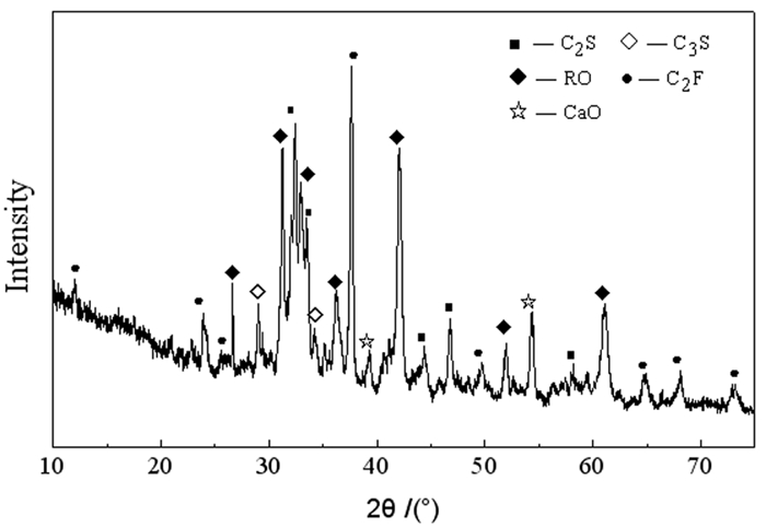
  • 图 1  钢渣的XRD图谱

    Figure 1. 

    图 2  不同龄期含镉试样的XRD图谱

    Figure 2. 

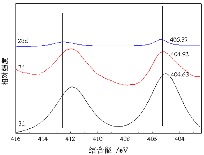
    图 3  含镉试样不同养护龄期的XPS(Cd)图谱(M2)

    Figure 3. 

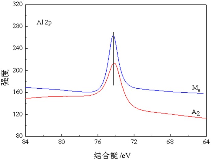
    图 4  M0和M2组试样28 d龄期时的XPS(Al)图谱

    Figure 4. 

    图 5  AFt相结构单元

    Figure 5. 

    表 1  原料的主要化学成分

    Table 1.  Chemical composition of materials /%

    原料 SiO2 Al2O3 Fe2O3 CaO MgO SO3 Na2O K2O TiO2 烧失量
    钢渣 19.16 7.39 18.66 43.58 7.56 0.26 0.10 0.12 1.65 1.52
    矿渣 29.15 11.37 2.66 41.23 10.67 1.11 0.27 0.32 1.45 1.77
    脱硫石膏 3.28 1.44 0.76 44.29 0.60 46.06 0.11 0.29 0.08 3.09
    下载: 导出CSV

    表 2  Cd2+浓度对固镉试样力学性能的影响

    Table 2.  Effect of Cd2+ concentration on mechanical properties of solid cadmium samples

    编号 龄期
    3 d 7 d 28 d
    M0 6.7 13.2 18.6
    M1 10.3 15.7 20.7
    M2 12.7 16.2 21.6
    M3 11.0 17.7 22.9
    下载: 导出CSV

    表 3  不同养护龄期固镉试样的Cd2+浸出浓度

    Table 3.  Cd2+ leaching concentration of Cd solid samples at different curing ages

    编号 Cd2+浸出浓度/ (mg·L-1)
    3 d 7 d 28 d
    M0 ND ND ND
    M1 0.001 ND ND
    M2 0.003 0.001 ND
    M3 0.004 0.002 ND
    注: ND代表低于检出限0.005 mg·L-1
    下载: 导出CSV
  • [1]

    LIN WANG, XIANGFEN CUI, HONGGUANG CHENG, et al. A review of soil cadmium contamination in China including a health risk assessment[J]. Environmental science and pollution research international, 2015, 22(21): 16441-16452. doi: 10.1007/s11356-015-5273-1

    [2]

    XIAOJUAN LIU, GUANGJIN TIAN, DONG JIANG, et al. Cadmium (Cd) distribution and contamination in Chinese paddy soils on national scale[J]. Environmental science and pollution research, 2016(23): 17941-17952. http://link.springer.com/10.1007/s11356-016-6968-7

    [3]

    HU YUANAN, CHENG HEFA, TAO SHU. The challenges and solutions for cadmium-contaminated rice in china: a critical review[J] Environment International, 2016(92-93): 515-532. http://www.sciencedirect.com/science/article/pii/s0160412016301714

    [4]

    环境保护部, 国土资源部. 全国土壤污染状况调查公报[R]. 2014.

    [5]

    余德彪, 王建平, 徐乐, 等. 中国镉资源现状分析及可持续发展建议[J]. 中国矿业, 2015, 24(4): 5-8. doi: 10.3969/j.issn.1004-4051.2015.04.002

    [6]

    周聪. 镉污染土壤原位修复技术的研究进展[J]. 有色冶金设计与研究, 2018, 39(5): 20-24+28. doi: 10.3969/j.issn.1004-4345.2018.05.006

    [7]

    刘群芳. 从镉污染分析环境安全保护管理策略[J]. 华南大学学报: 社会科学版, 2013, 14(3): 65-67. https://www.cnki.com.cn/Article/CJFDTOTAL-NHDS201303018.htm

    [8]

    JINGJING LIU, FUSHENG ZHA, XU LONG, et al. Effect of chloride attack on strength and leaching properties of solidified/stabilized heavy metal contaminated soils[J]. Engineering geology, 2018(246): 28-35. http://www.sciencedirect.com/science/article/pii/S0013795218305477

    [9]

    HAO LIANG WU, FEI JIN, YU LIN BO, et al. Leaching and microstructural properties of lead contaminated kaolin stabilized by GGBS-MgO in semi-dynamic leaching tests[J]. Construction and building materials, 2018(172): 626-634. http://www.sciencedirect.com/science/article/pii/S0950061818306639

    [10]

    赵述华, 陈志良, 张太平, 等. 重金属污染土的固化/稳定化处理技术研究进展[J]. 土壤通报, 2013, 44(6): 1531-1536. https://www.cnki.com.cn/Article/CJFDTOTAL-TRTB201306044.htm

    [11]

    HANGHANG ZHAO, XUNRONG HUANG, GUIBIN ZHANG, et al. Possibility of removing cadmium pollution from the environment using a newly synthesized material coal fly ash[J]. Environmental science and pollution research international, 2020(27): 4997-5008. doi: 10.1007/s11356-019-07163-x

    [12]

    LI JIANGSHAN, XUE QIANG, WANG PING, et al. Effect of drying-wetting cycles on leaching behavior of cement solidified lead-contaminated soil[J]. Chemosphere, 2014(117): 10-13. http://www.sciencedirect.com/science/article/pii/S0045653514006870

    [13]

    Wang F., Shen Z. T., Abir A. T. An evaluation of stabilised/solidified contaminated model soil using PC-based and Mg O-based binders under semi-dynamic leaching conditions[J]. Environmental science and pollution research, 2018, 25(16): 16050-16060. doi: 10.1007/s11356-018-1591-4

    [14]

    PAN YIZE, ROSSABI JOSEPH, PAN CHONGGEN, et al. Stabilization/solidification characteristics of organic clay contaminated by lead when using cement[J]. Journal of hazardous materials, 2019, (362): 132-139.

    [15]

    YASONG FENG, YANJUN DU, WEIYI XIA., et al. Diffusion characteristics of Lead, Zinc, Cadmium in a novel phosphate-based binder stabilized soil[C]. The international congress on environmental geotechnics, Springer, Singapore, 2018: 669-675.

    [16]

    洪正义, 孙树林. 钢渣-水泥固化Cd污染土的强度特性研究[J]. 科学技术与工程, 2016, 16(8): 248-253. doi: 10.3969/j.issn.1671-1815.2016.08.042

    [17]

    崔孝炜, 倪文, 任超. 钢渣矿渣基全固废胶凝材料的水化反应机理[J]. 材料研究学报, 2017, 31(9): 687-694. https://www.cnki.com.cn/Article/CJFDTOTAL-CYJB201709007.htm

    [18]

    蓝俊康, 丁凯, 王焰新. 钙矾石对Pb, Zn, Cd的化学俘获[J]. 桂林工学院学报, 2005, 25(3): 330-334. doi: 10.3969/j.issn.1674-9057.2005.03.015

    [19]

    POMIES M P, LEQUEUS N, BOCH P. Speciation of cadimium in cement made from raw mixcontaining transition osides[J]. Cement & Concrete Research, 1988(28): 335-340.

    [20]

    姚燕, 王昕, 颜碧兰, 等. 水泥水化产物结构及其对重金属离子固化研究进展[J]. 硅酸盐通报, 2012, 31(5): 1138-1144. https://www.cnki.com.cn/Article/CJFDTOTAL-GSYT201205021.htm

    [21]

    田犀卓, 金兰淑, 应博, 等. 钢渣-蒙脱石复合吸附剂对水中Cd2+的吸附去除[J]. 环境科学学报, 2015, 35(1): 207-214. https://www.cnki.com.cn/Article/CJFDTOTAL-HJXX201501025.htm

    [22]

    杨恒, 倪文, 张思奇, 等. 胶结充填用冶金渣协同垃圾焚烧飞灰固镉机理[J]. 工程科学学报, 2018, 40(9): 1027-1035. https://www.cnki.com.cn/Article/CJFDTOTAL-BJKD201809002.htm

    [23]

    JUANJUAN ZHANG, HE ZHAO, HONGBIN CAO, et al. Removal of Cd~(2+) from water by Friedel's salt (FS: 3CaO·AL2O3·CaCl2·10H2O): Sorption characteristics and mechanisms[J]. Journal of environmental sciences, 2013, 25(9): 1719-1725. doi: 10.1016/S1001-0742(12)60287-3

    [24]

    V. ALBINO, R. CIOFFI, M. MARROCCOLI, et al. Potential application of ettringite generating systems for hazardous waste stabilization[J]. Hazardous materials, 1996, 51(1-3): 241-252. doi: 10.1016/S0304-3894(96)01828-6

    [25]

    张娟娟, 赵赫, 曹宏斌, 等. Friedel盐对废水中低浓度Cd2+的吸附动力学. 过程工程学报, 2012, 12(4): 590-595. https://www.cnki.com.cn/Article/CJFDTOTAL-HGYJ201204012.htm

    [26]

    A.M. CODY, H. LEE, R. D. CODY, et al. The effect of environment on the nucleation, growth, and stability of ettringite[Ca2Al(OH)6]2·(SO4)3·26H2O[J]. Cement and Concrete Research, 2004(34): 869-881. http://www.sciencedirect.com/science/article/pii/S000888460300382X

  • 加载中

(5)

(3)

计量
  • 文章访问数:  1595
  • PDF下载数:  75
  • 施引文献:  0
出版历程
收稿日期:  2021-01-05
刊出日期:  2021-02-25

目录

  • 表 1.  数据库(集)元数据简介
    条目 描述
    数据库(集)名称 内蒙北柳图庙幅1∶50 000地质图数据库
    数据库(集)作者 沉积岩类: 刘 洋, 中国地质调查局天津地质调查中心
    火山岩类: 滕 飞, 中国地质调查局天津地质调查中心
    岩浆岩类: 王文龙, 中国地质调查局天津地质调查中心
    变质岩类: 杨泽黎, 中国地质调查局天津地质调查中心
    数据时间范围 2016—2018年
    地理区域 经纬度: 东经113°00′~113°30′; 北纬42°00′~42°20′
    数据格式 MapGIS
    数据量 28.9 MB
    数据服务系统网址 http://dcc.cgs.gov.cn
    基金项目 中国地质调查局地质调查项目“内蒙古温都尔庙-镶黄旗地区区域地质调查” (项目编号: DD20190038)
    语种 中文
    数据库(集)组成 北柳图庙幅1∶50 000地质图数据库包括: 1∶50 000地质图库、角图和图饰。地质图库包括沉积岩、火山岩、侵入岩、第四系、构造形迹、地质界线、产状、矿化(点)、蚀变、岩性花纹、各类代号等。角图包括综合柱状图、侵入岩填图单位、图切剖面、大地构造位置图。图饰包括接图表、图例、责任表等
     | Show Table
    DownLoad: CSV
  • 表 2.  地质图空间数据库数据属性表
    数据类型 名称 标准编码 数据项属性
    基本要素类 地质体面实体 _GeoPolygon 地质体面实体标识号, 地质体面实体类型代码, 地质体面实体名称, 地质体面实体时代, 地质体面实体下限年龄值, 地质体面实体上限年龄值, 子类型标识
    地质(界)线 _GeoLine 要素标识号, 地质界线代码, 地质界线类型, 界线左侧地质体代号, 界线右侧地质体代号, 界面走向, 界面倾向, 界面倾角, 子类型标识
    产状 _Attitude 要素标识号, 产状类型名称代码, 产状类型名称, 走向, 倾向, 倾角, 子类型标识
    样品 _Sample 要素标识号, 样品编号, 样品类型代码, 样品类型名称, 样品岩石名称, 子类型标识
    照片 _Photograph 要素标识号, 照片编号, 照片题目, 照片说明, 子类型标识
    素描 _Sketch 要素标识号, 素描编号, 素描题目, 素描说明, 子类型标识
    化石 _Fossil 要素标识号, 化石样品编号, 化石所属生物门类, 化石属或种名, 化石产出层位, 含化石地层单位代号, 化石时代, 子类型标识
    同位素测年 _Isotope 要素标识号, 样品编号, 样品名称, 年龄测定方法, 测定年龄, 被测定出地质体单位及代号, 测定分析单位, 测定分析日期, 子类型标识
    火山口 _Crater 要素标识号, 火山口类型, 火山口名称, 火山口大小, 火山口产出的地质体单位及代号, 火山口岩石类型, 火山口形成时代, 子类型标识
    _Spring 要素标识号, 泉类型代码, 泉类型名称, 泉水流量, 泉水温度, 泉的地质体单位及代号, 子类型标识
    河、湖、海、水库岸线 _Line_Geography 要素标识号, 图元类型, 图元名称, 子类型标识
    综合要素类 构造变形带 _Tectzone 要素标识号, 变形带代码, 变形带类型名称, 变形带岩石名称, 变形带组构特征, 变形带力学特征, 形成时代, 活动期次, 含矿性, 子类型标
    蚀变带(面) _Alteration_Polygon 要素标识号, 蚀变类型名称代码, 蚀变类型名称, 蚀变矿物组合及含量, 含矿性, 被蚀变的地质体代号, 子类型标
    火山岩相带 _Volca_Facies 要素标识号, 火山岩岩相类型及代码, 产出的地层单位及代号, 火山岩相岩石类型, 岩石结构, 岩石构造, 流面产状, 流线产状, 形成时代, 含矿性, 子类型标识
    标准图框(内图框) _Map_Frame 图名, 图幅代号, 比例尺, 坐标系统, 高程系统, 左经度, 下纬度, 图形单位
    对象类 沉积(火山)岩岩石地层单位 _Strata 要素分类, 地层单位名称, 地层单位符号, 地层单位时代, 岩石组合名称, 岩石组合主体颜色, 岩层主要沉积构造, 生物化石带或生物组合, 地层厚度, 含矿性, 子类型标识
    侵入岩岩石年代单位 _Intru_Litho_Chrono 要素分类, 岩体填图单位名称, 岩体填图单位符号, 岩石名称(岩性), 岩石颜色, 岩石结构, 岩石构造, 岩相, 主要矿物及含量, 次要矿物及含量, 与围岩接触关系, 围岩时代, 与围岩接触面走向, 与围岩接触面倾向, 与围岩接触面倾角, 流面产状, 流线产状, 形成时代, 含矿性, 子类型标识
    断层 _Fault 要素分类代码, 断层类型, 断层名称, 断层编号, 断层性质, 断层上盘地质体代号, 断层下盘地质体代号, 断层破碎带宽度, 断层走向, 断层倾向, 断层面倾角, 估计断距, 断层形成时代, 活动期次, 子类型标识
    脉岩(面) _Dike_Object 脉岩分类代码, 脉岩名称, 脉岩符号, 岩性, 颜色, 结构, 构造, 主要矿物及含量, 次要矿物及含量, 与围岩接触面走向, 与围岩接触面倾向, 与围岩接触面倾角, 形成时代, 含矿性, 子类型标识
    非正式地层单位 _INF_STRATA 要素分类代码, 非正式地层单位代码, 岩性, 岩石结构构造, 所含生物化石带或生物组合, 出露宽度或厚度, 含矿性, 所在地层单位符号, 子类型标识
    面状水域 _Water_Region 要素分类代码, 图元类型, 图元名称, 图元特征, 子类型标识
    图幅基本信息 _Sheet_Mapinfo 地形图编号, 图名, 比例尺, 坐标系统, 高程系统, 左经度, 右经度, 上纬度, 下纬度, 成图方法, 调查单位, 图幅验收单位, 评分等级, 完成时间, 出版时间, 资料来源, 数据采集日期
     | Show Table
    DownLoad: CSV
  • 表 3.  岩石地层填图单位划分表
    年代地层 岩石地层单位划分 地层代号 岩性描述
    新生界 第四系 全新统 湖积物 Qhl 由灰黑、灰绿、砂质淤泥、黏土、砂土、砂砾组成
    冲积物 Qhal 位于现代河床中, 由杂色松散堆积的砂砾层、中砂、砂黏土
    等组成
    洪冲积物 Qhpal 多形成低缓台地, 堆积物主要为黄褐色砂砾、砂及黏土, 砾
    石分选差, 成分复杂
    上更新统 洪冲积物 Qp3pal 堆积物主要为黄褐色砂砾、砂及黏土, 分选磨圆差, 成分复
    新近系 中新统 汉诺坝组 N1h 灰、灰黑色致密状、气孔状伊丁玄武岩、橄榄玄武岩
    中生界 白垩系 下统 固阳组 K1g 灰色砾岩、砂砾岩夹泥岩、黑色泥岩夹煤层, 含大量植物化
    白音高老组 K1b 流纹质火山集块岩、流纹质角砾岩屑凝灰岩、流纹质岩屑晶
    屑凝灰岩、流纹岩
    侏罗系 上统 玛尼图组 J3mn 安山质-粗安质集块岩和集块角砾岩、辉石安山岩、角闪安山
    岩、安山岩、粗安岩、含火山角砾的安山质角砾熔岩、安山质-
    粗安质火山角砾岩
    古生界 二叠系 下统 三面井组 P1s2 中粗粒(含砾)岩屑长石杂砂岩、中细粒岩屑长石杂砂岩、细
    砂岩质板岩、泥质粉砂岩
    P1s1 青灰色、灰黄色䗴灰岩、炭质板岩、炭质灰岩和生物碎屑灰岩
    夹青灰色、灰褐色泥质板岩、粉砂质板岩、中细粒岩屑长石砂
    志留系 上统 白乃庙组 二段 S3-4b2 安山质-英安质凝灰岩、火山角砾岩、凝灰质细-粉砂岩、绿片
    岩、变质安山质凝灰岩、绿帘绿泥片岩、绢云绿泥片岩、绿泥
    钠长阳起石片岩、白云母石英片岩、灰黑色变质安山岩、变质
    安山质集块岩
    一段 S3-4b1 浅灰色英安岩、灰白色流纹岩及红柱石绢云片岩、片理化变
    质砂岩、绿泥黑云母石英砂岩、二云绿帘石英片岩、斜长变粒
    岩、绿泥阳起片岩
     | Show Table
    DownLoad: CSV
  • 表 4.  古生代侵入岩演化序列一览表
    时代 填图单位 主体岩性 主要分布位置 形状与产状 主要接触关系 LA–ICP–MS锆石U–Pb年龄/Ma
    中二叠世晚期 xηγP2 肉红色细粒
    二长花岗岩
    温都尔呼特勒—
    脑干尚达一带
    岩基 侵入zxβηγP2
    zxψβγδP2、P1s1
    263.9±1.1
    zxηγP2 肉红色中细粒二长
    花岗岩
    温都尔呼特勒-
    脑干尚达一带
    岩基 侵入zxβηγP2
    P1s2
    中二叠世早期 zxψβγδP2 灰白色中细粒角闪
    黑云花岗闪长岩
    古日班额博勒
    者—阿日音乌苏一带
    岩基 侵入zcγδοS3
    δοS3、P1s1
    268.4±1.6
    zxπδoP2 灰白色中细粒斑状
    石英闪长岩
    包哈音沃博勒
    者、阿日音乌苏附近
    岩基 侵入zxγδοS3
    zγδοS3、P1s1
    晚志留世 γδοS3 灰白色中粒斑状英
    云闪长岩
    苏吉—乌泥脑包
    一带
    岩基 侵入zxγδοS3,
    被xηγP2、侵入
    423.1±1.5
    zxπγδοS3 灰白色中细粒斑状
    英云闪长岩
    苏吉—乌泥脑包
    一带
    岩基 侵入zxγδοS3,
    被xηγP2侵入
    zcγδοS3 灰白色中粗粒英云
    闪长岩
    哈日敖包—乌日
    舍勒图一带
    岩基 被zπγδοS3
    zxπγδοS3侵入,
    侵入zxβγδS1
    425.8±1.6
    zγδοS3 灰白色中粒英云闪
    长岩
    哈日敖包—乌日
    舍勒图一带
    岩基 被zπγδοS3
    zxπγδοS3侵入,
    侵入zxβγδS1
    434.2±2.2
    zxγδοS3 灰白色中细粒英云
    闪长岩
    哈日敖包—乌日
    舍勒图一带
    岩基 被zπγδοS3
    zxπγδοS3侵入,
    侵入zxβγδS1
    晚寒武世 xγgnЄ3 灰白色细粒含石榴
    白云母花岗岩
    毕鲁图庙西北
    角出山口西侧
    岩枝 被zγδοS3侵入,
    与白乃庙群为
    断层接触
    500.8±2.4
    注:x表示细粒; z表示中粒; zc表示中粗粒; zx表示中细粒。
     | Show Table
    DownLoad: CSV
  • 表 5.  内蒙古北柳图庙幅(K49E011021)地质图空间数据库测试分析数据表
    数据类型 数据量 数据基本特征
    岩石化学分析数据 176件 火山岩、侵入岩的11种主量元素
    微量元素分析数据 176件 火山岩、侵入岩的31种微量元素
    同位素年龄数据 10件 火山岩、侵入岩、碎屑岩的LA–ICP–MS锆石U-Pb同位素年龄
     | Show Table
    DownLoad: CSV
  • Table 1.  Metadata Table of Database (Dataset)
    Items Description
    Database (dataset) name 1∶50 000 Geological Map Database of Beiliutumiao Map-sheet, Inner Mongolia
    Database (dataset) authors Sedimentary rocks: Liu Yang, Tianjin Center, China Geological Survey
    Volcanic rocks: Teng Fei, Tianjin Center, China Geological Survey
    Igneous rocks: Wang Wenlong, Tianjin Center, China Geological Survey
    Metamorphic Rocks: Yang Zeli, Tianjin Center, China Geological Survey
    Data acquisition time 2016—2018
    Geographic area 113°00′–113°30′ E, 42°00′–42°20′ N
    Data format MapGIS
    Data size 28.9 MB
    Data service system URL http://dcc.cgs.gov.cn
    Fund project China Geological Survey project named “Regional Geological Survey in Wenduermiao-Xianghuang Banner Area, Inner Mongolia” (DD20190038)
    Language Chinese
    Database (dataset) composition The 1∶50 000 Geological Map Database of Beiliutumiao Map-sheet includes: 1∶50 000 geological map, mosaic maps and map decorations. The geological map includes sedimentary rocks, volcanic rocks, intrusive rocks, Quaternary, structural feature, geological boundary, attitude, mineralized spot, alteration, lithological pattern and various codes. The mosaic maps include comprehensive stratigraphic columns, intrusive rock mapping units, map cross sections and geotectonic locations. Map decorations include map sheet indices, legends of master maps, an author information table
     | Show Table
    DownLoad: CSV
  • Table 2.  Data attribute of the geological map spatial database
    Data type Name Standard code Attribute of data item
    Basic elemen Geobody surface _GeoPolygon Geobody surface identification number, geobody surface type code, geobody surface name, geobody surface era, lower age limit of geobody surface, upper age limit of geobody surface, sub-type identification
    Geological boundary line _GeoLine Element identification number, geological boundary code, geological boundary type, code of geobody on the left side of the boundary, code of geobody on the right side of the boundary, interface strike, interface dip, interface dip angle, sub-type identification
    Attitude _Attitud Element identification number, attitude type code, attitude type name, strike, dip, dip angle, sub-type identification
    Sample _Sample Element identification number, sample number, sample type code, sample type name, sample rock name, sub-type identification
    Photo _Photograph Element identification number, photo number, photo title, photo caption, sub-type identification
    Sketch _Sketch Element identification number, sketch number, sketch title, sketch description, sub-type identification
    Fossil _Fossil Element identification number, fossil sample number, biological category of fossil, genus or species of fossil, fossil horizon, code number of fossil-bearing stratigraphic unit, fossil era, sub-type identification
    Isotopic dating _Isotope Element identification number, sample number, sample name, age determination method, measured age, unit and code of measured geobody, unit conducting measurement and analysis, date of measurement and analysis, sub-type identification
    Crater _Crater Element identification number, crater type, crater name, crater size, unit and code of geobody with crater, crater rock type, crater formation era, sub-type identification
    Spring _Spring Element identification number, spring type code, spring type name, spring flow rate, spring temperature, unit and code of geobody with spring, sub-type identification
    River, lake, sea and reservoir coastline _Line_Geograph Element identification number, map element type, map element name, sub-type identification
    Comprehensive element Tectonic deformation zone _Tectzone Element identification number, code of deformation zone, type of deformation zone, deformation zone rock name, structural characteristics of deformation zone, mechanical characteristics of deformation zone, formative era, active period, ore-bearing, sub-type identification
    Altered zone _Alteration_Polygon Element identification number, alteration type code, alteration type name, mineral association and content of alteration, ore-bearing, altered geobody code, sub-type identification
    Volcanic facies belt _Volca_Facies Element identification number, volcanic lithofacies type and code, stratigraphic unit and code, lithofacies type of volcanic rock, rock structure, rock fabric, flow surface attitude, flowline attitude, formative era, ore-bearing, sub-type identification
    Standard frame (inner frame) _Map_Frame Map name, map-sheet code, scale, coordinate system, elevation system, left longitude, lower latitude, graphic unit
    Object Lithostratigraphic unit of sedimentary (volcanic) rock _Strat Element category, stratigraphic unit name, stratigraphic unit symbol, stratigraphic unit era, rock association name, main color of rock association, main sedimentary structure of rock formation, biological fossil zone or biological assemblage, stratigraphic thickness, ore-bearing, sub-type identification
    Geochronological unit of intrusive rock _Intru_Litho_Chrono Element category, name of rock mass mapping unit, rock mass mapping unit symbol, rock name (lithology), rock color, rock structure, rock fabric, lithofacies, primary minerals and content, secondary minerals and content, contact relation with surrounding rock, surrounding rock era, strike of contact surface with surrounding rock, dip direction of contact surface with surrounding rock, dip angle of contact surface with surrounding rock, attitude of flow surface, attitude of flowline, formative era, ore-bearing, sub-type identification
    Fault _Fault Element category code, fault type, fault name, fault number, fault nature, code of hanging wall of fault, code of heading wall of fault, fault fracture zone width, fault strike, fault dip, fault plane dip angle, estimated fault distance, fault formative era, active period and sub-type identification
    Dike rock (face) _Dike_Object Dike rock classification code, dike rock name, dike rock symbol, lithology, color, structure, tectonics, main minerals and content, secondary minerals and content, strike of contact surface with surrounding rock, dip direction of contact surface with surrounding rock, dip angle of contact surface with surrounding rock, formative era, ore-bearing property and sub-type identification
    Informal stratigraphic unit _INF_STRATA Element category code, informal stratigraphic unit code, lithology, rock structure, biological fossil zone or biological assemblage, outcrop width or thickness, ore-bearing, symbol of stratigraphic unit, sub-type identification
    Planar water area _Water_Region Element category code, map element type, map element name, map element feature, sub-type identification
    Basic information of map-sheet _Sheet_Mapinfo Topographic map number, map name, scale, coordinate system, elevation system, left longitude, right longitude, upper latitude, lower latitude, mapping method, investigation unit, map acceptance unit, scoring grade, completion time, publication time, data source, data collection date
     | Show Table
    DownLoad: CSV
  • Table 3.  Division of lithostratigraphic mapping units
    Chronostratigraphy Division of lithostratigraphic
    units
    Stratumcode name Lithologic description
    Boundary System Series
    Cenozoic Quaternar System Holocene Lacustrine sediment Qhl Composed of grey-black, grey-green, sandy silt, clay sand, and gravel.
    Alluvium Qhal Located in the modern riverbed, composed of mottled and loosely piled sand and gravel layers, medium sand, and sandy clay.
    Flood alluvium Qhpa Mostly forming low and gentle platforms, with deposits being mainly yellow-brown gravel, sand and clay. The gravel is poorly sorted and has complex composition.
    Upper Pleistocene Flood alluvium Qp3pal The deposits are mainly yellow-brown gravel, sand and clay, poorly sorted and rounded, with complex composition.
    Neogene Miocene Hannuoba Formation N1h Grey and grey-black compact, vesicular iddingsite basalt and olivine basalt
    Mesozoic Cretaceous Lower Series Guyang Formation K1g Grey conglomerate, sandy conglomerate mixed with mudstone, black mudstone mixed with coal seam, rich in plant fossils
    Baiyingaolao Formation K1b Rhyolitic volcanic agglomerate, rhyolitic breccia tuff, rhyolitic crystal tuff, rhyolite
    Jurassic Upper Series Manitu Formation J3mn Anesite-trachytic agglomerate and agglomerate breccia, pyroxene andesite, hornblende andesite, andesite, trachyandesite, volcanic breccia-bearing andesitic breccia lava, andesite-trachyandesitic volcanic breccia
    Paleozoic Permian Lower Series Sanmianjing Formation P1s2 Medium-coarse-grained (gravelly) lithic feldspar greywacke, medium-fine-grained lithic feldspar greywacke, fine sandstone slate, argillaceous siltstone
    P1s1 Blue-grey, grey-yellow fusulinid limestone, carbonaceous slate, carbonaceous limestone and bioclastic limestone mixed with blue-grey, grey-brown argillaceous slate, silty slate, medium-fine-grained lithic feldspathic sandstone
    Silurian System Upper Series Bainaimiao Formation Second Member S3-4b2 Andesite-dacite tuff, volcanic breccia, tuff fine-siltstone, chlorite schist, metamorphic andesitic tuff, epidote-chlorite schist, sericite chlorite schist, chlorite-albitite actinolite schist, muscovite quartz-schist, grey-black metamorphic andesite, metamorphic andesitic agglomerate
    First Member S3-4b1 Light-grey dacite, grey-white rhyolite and andalusite-sericite schist, schistositized metamorphic sandstone, chloritized biotite quartz-sandstone, two-mica epidote quartz schist, plagioclase granulite, chlorite actinolite schist
     | Show Table
    DownLoad: CSV
  • Table 4.  List of evolutionary sequences of Paleozoic intrusive rock
    Era Mapping unit Main
    lithology
    Main
    distribution
    Shape and attitude Main contact relation LA-ICP-MS zircon U–Pb age/Ma
    Late stage of Middle Permian xηγP2 Meat-red fine-grained monzonitic granite Wenduerhutele-Naoganshangda area Rock foundation Intrusion into zxβηγP2, zxψβγδP2, P1s1 263.9±1.1
    zxηγP2 Meat-red medium-fine-grained monzonitic granite Wenduerhutele-Naoganshangda area Rock foundation Intrusion into zxβηγP2, P1s2
    Early stage of Middle Permian zxψβγδP2 Grey-white medium-fine-grained hornblende biotite granodiorite Guribanebolezhe-Ariyinwusu area Rock foundation Intrusion into zcγδοS3, zγδοS3, P1s1 268.4±1.6
    zxπδoP2 Grey-white medium-fine-grained porphyry tonalite Vicinity of Baohayinwobolezhe, Ariyinwusu Rock foundation 侵入zxγδοS3、zγδοS3、P1s1Intrusion into zxγδοS3, zγδοS3, P1s1
    Late Silurian γδοS3 Grey-white medium-grained porphyry tonalite Suji-Wuninaobao area Rock foundation Intrusion into zxγδοS3, intruded by xηγP2 423.1±1.5
    zxπγδοS3 Grey-white medium-fine-grained porphyry tonalite Suji-Wuninaobao area Rock foundation Intrusion into zxγδοS3, intruded by xηγP2
    zcγδοS3 Grey-white medium-coarse-grained porphyry tonalite Hariaobao-Wurisheletu area Rock foundation Intruded by zπγδοS3, zxπγδοS3, Intrusion into zxβγδS1 425.8±1.6
    zγδοS3 Grey-white medium-grained tonalite Hariaobao-Wurisheletu area Rock foundation Intruded by zπγδοS3, zxπγδοS3,intrusion into zxβγδS1 434.2±2.2
    zxγδοS3 Grey-white medium-fine-grained tonalite Hariaobao-Wurisheletu area Rock foundation Intruded by zπγδοS3, zxπγδοS3, Intrusion into zxβγδS1
    Late Cambrian xγgnЄ3 Grey-white fine-grained garnet-bearing muscovite granite West side of the northwest corner exit of Bilutumiao Apophysis Intruded by zγδοS3; forms fault contact with Bainaimiao Group 500.8±2.4
      Note: x denotes fine-grained; z represents medium-grained; zc: medium-coarse grained; zx: medium-fine grained.
     | Show Table
    DownLoad: CSV
  • Table 5.  Test and analysis data of the geological map spatial database of Beiliutumiao map-sheet, Inner Mongolia (K49E011021)
    Data type Data volume Basic characteristics of data
    Petrochemical analysis 176 pieces 11 major elements of volcanic and intrusive rocks
    Trace element analysis 176 pieces 31 trace elements of volcanic and intrusive rocks
    Isotopic age 10 pieces LA-ICP-MS zircon U–Pb isotopic ages of volcanic, intrusive and clastic rocks
     | Show Table
    DownLoad: CSV