

ASSESSMENT OF SEAWATER INTRUSION IN THE COASTAL PLAIN AQUIFERS OF YANG-DAI RIVER USING DC-RESISTIVITY METHODS
-
摘要:
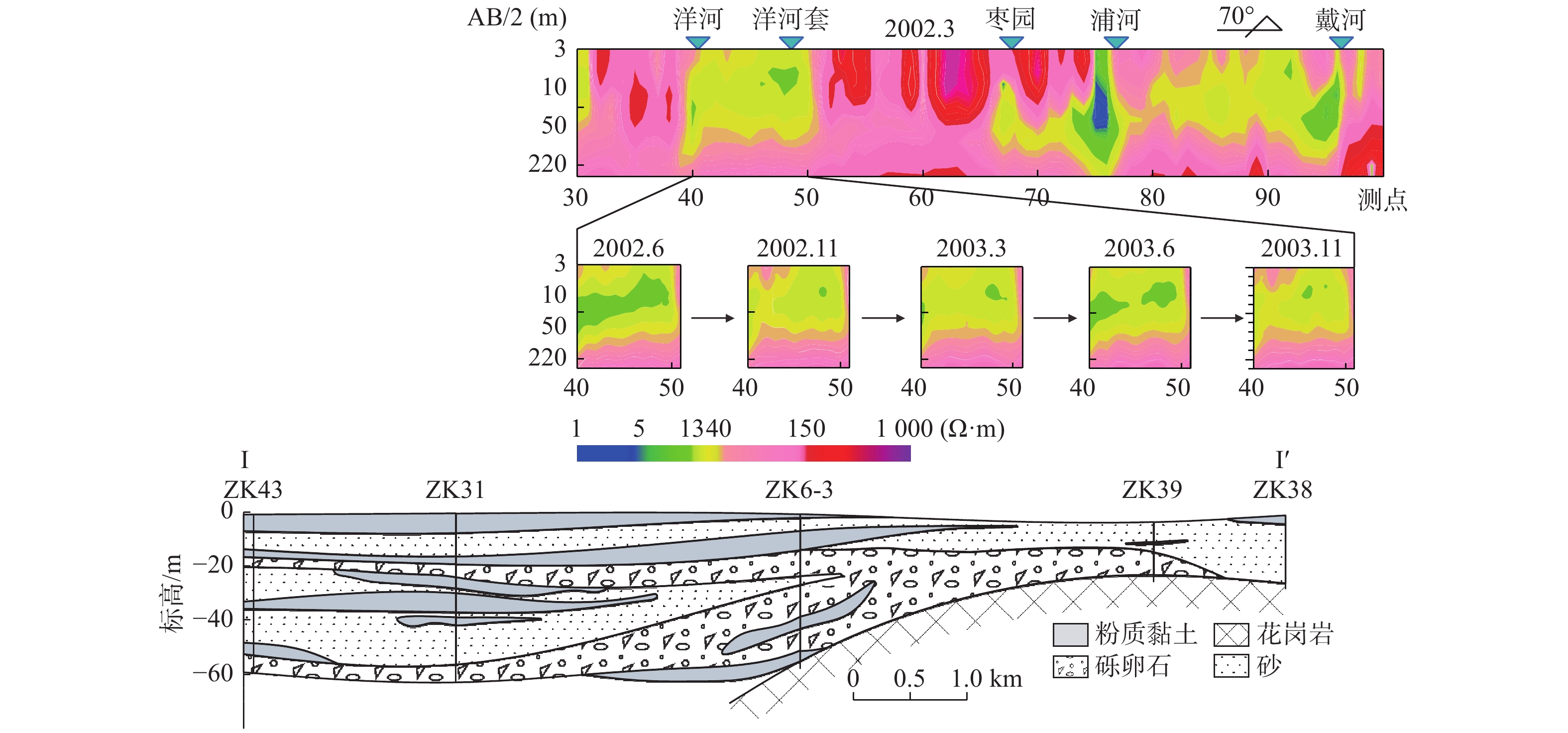
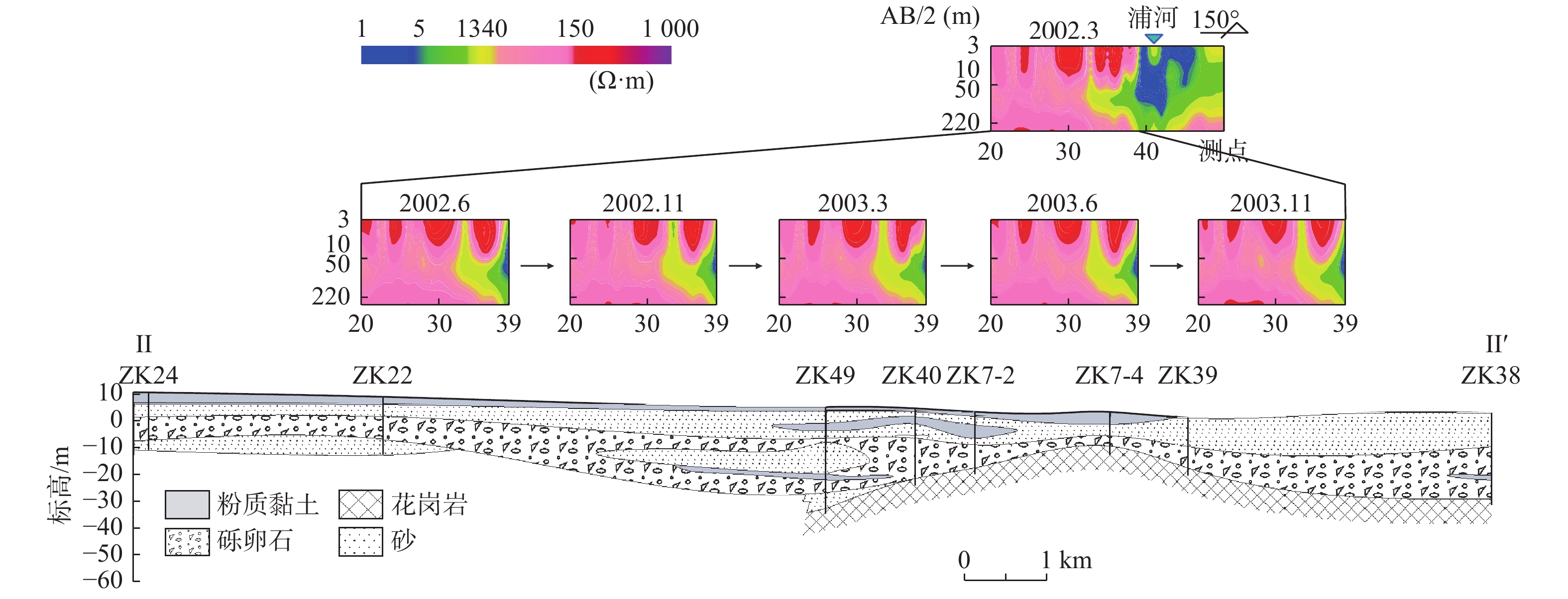
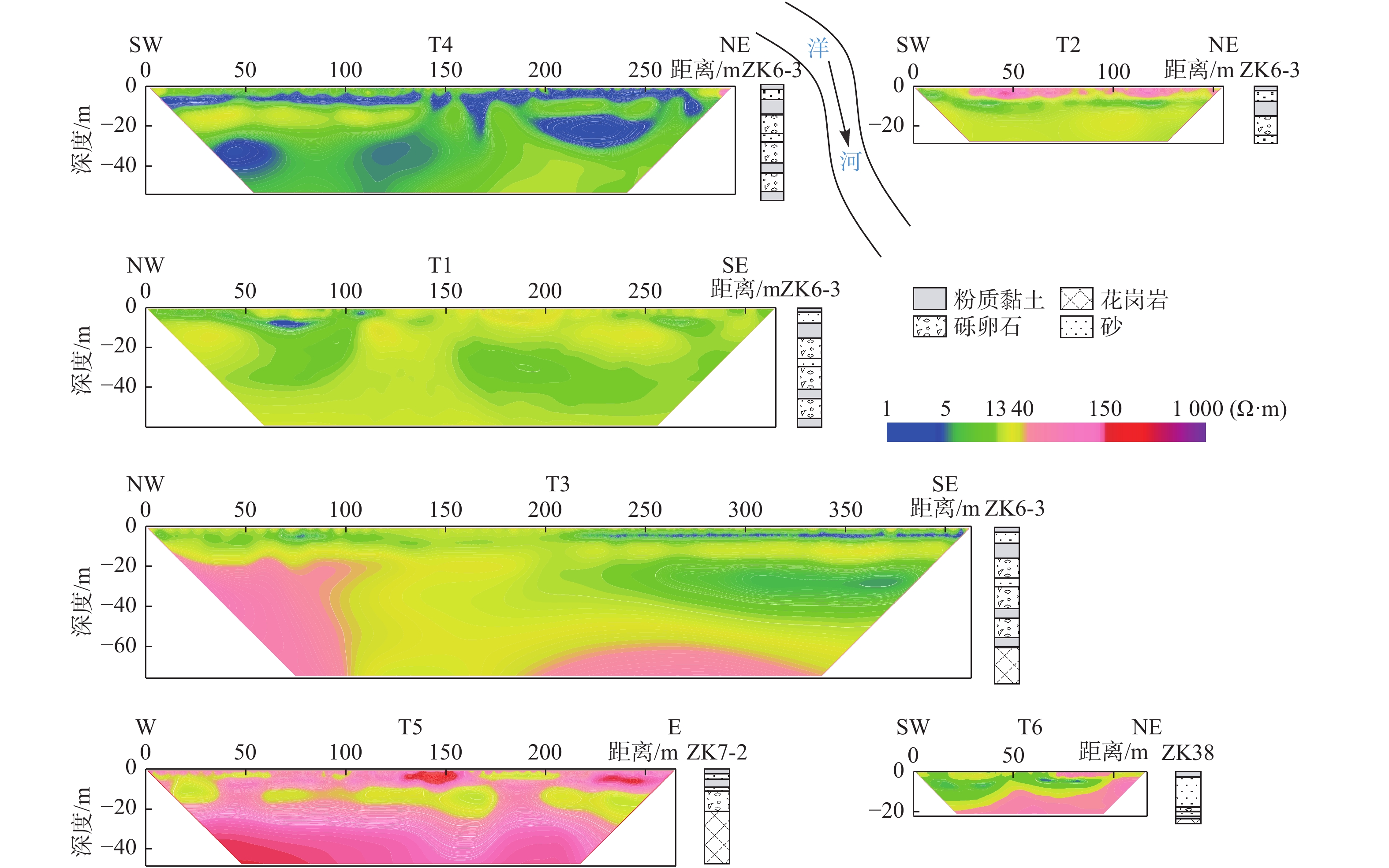
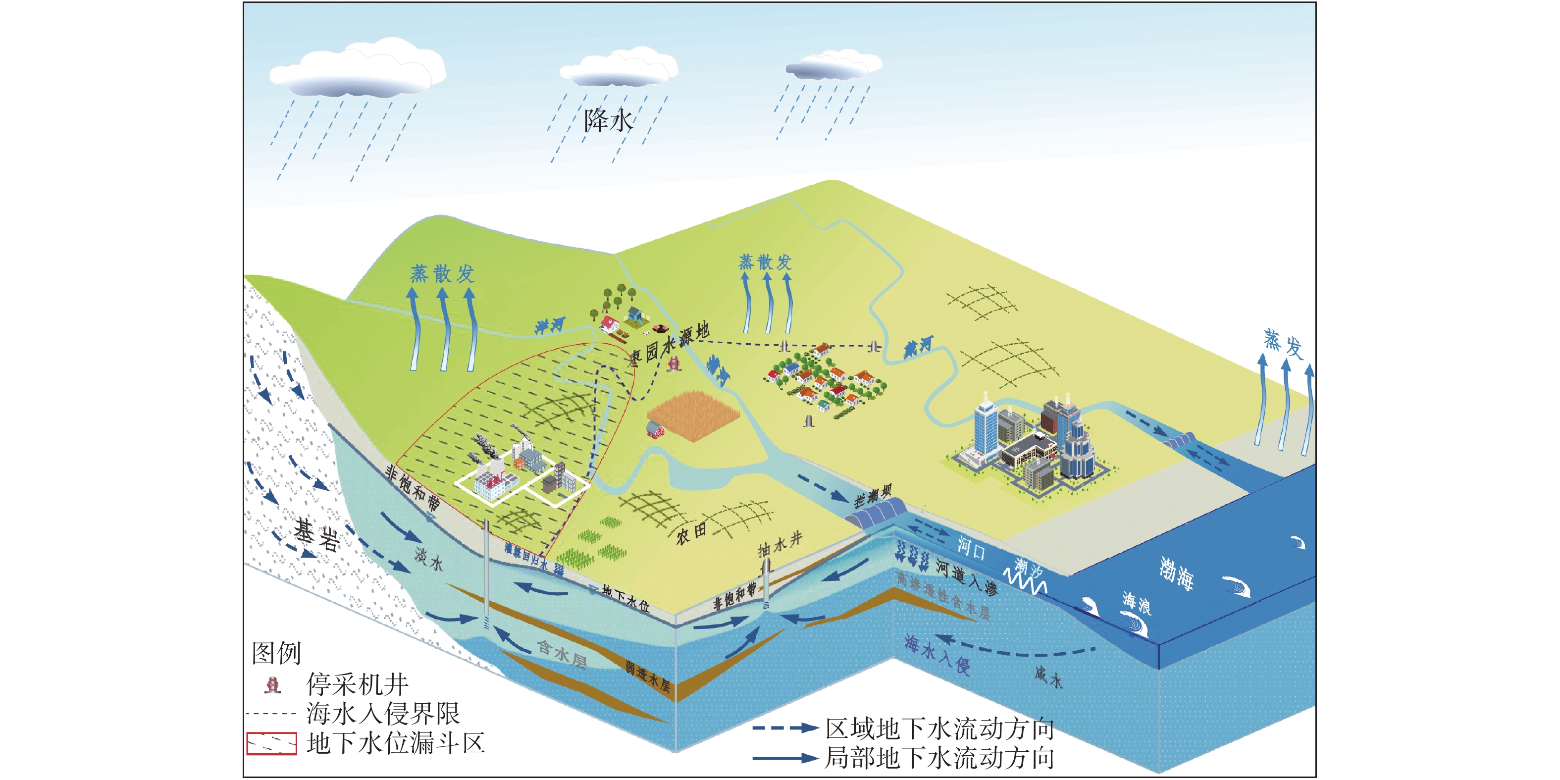
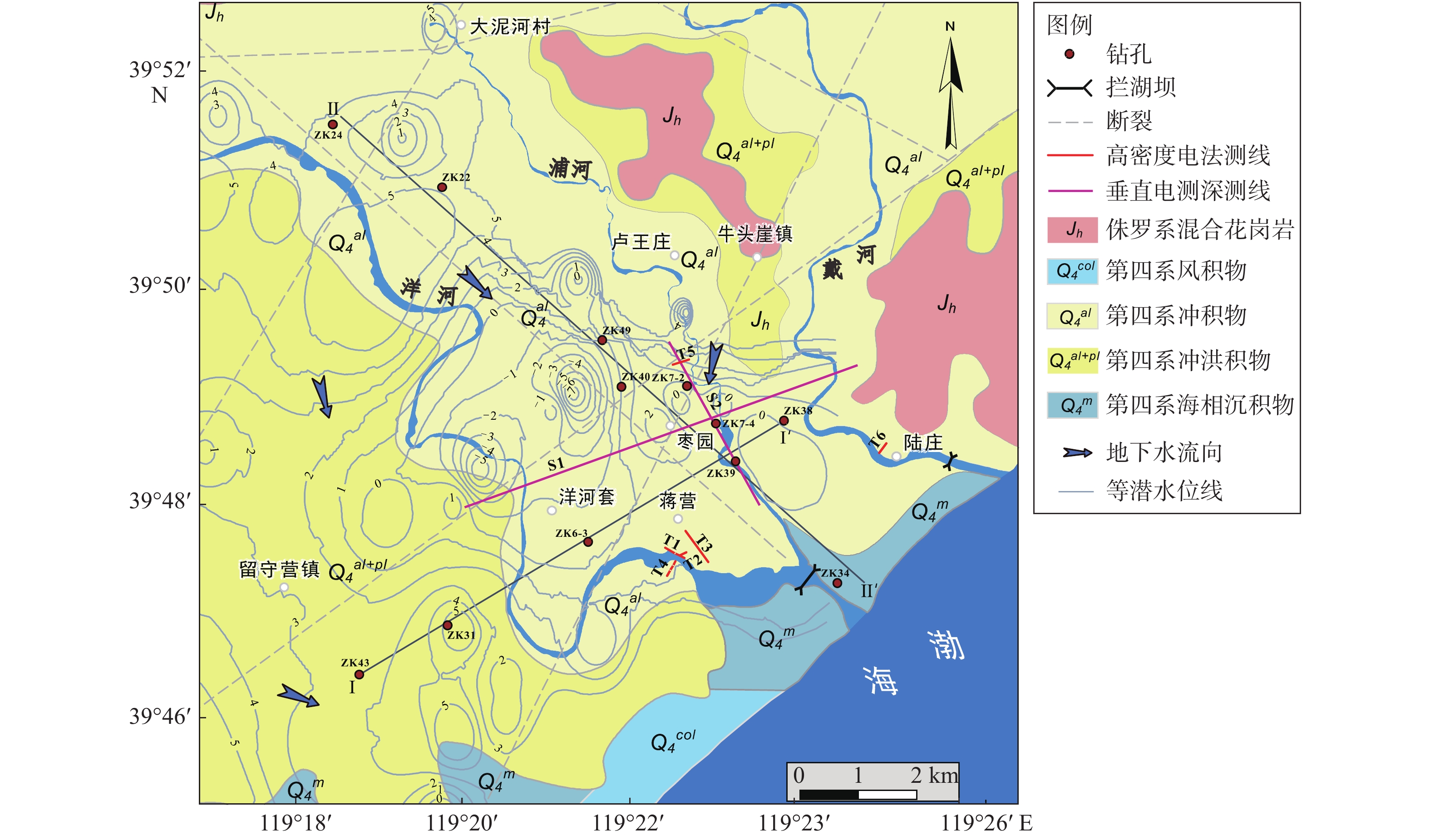
海水和淡水之间的显著电性差异使得直流电阻率法可用于识别和监测海水入侵。洋戴河平原不同海水入侵程度含水层,其电阻率呈现出显著分异,一般规律为:严重入侵(<5 Ω∙m),轻度入侵(5~13 Ω∙m),未入侵(13~150 Ω∙m)。结合水文地质钻孔资料,依靠含水层电阻率分布识别海水入侵。结果表明,洋戴河平原部分地区海水入侵进程具有明显的季节效应,由于农灌开采地下水导致6月海水入侵程度较为严重,3、11月海水入侵程度相对较弱。研究区滨海浅层地下咸水(微咸水)区主要分布在河道两侧,并向周围抽水灌溉区发展,其主要来源是海水沿河床入侵后形成的混合咸水以及灌溉回归水。现有的措施已经对海水入侵发展起到了一定的减缓作用,但仍需加强典型地段的防治。
-
关键词:
- 洋戴河平原 /
- 垂直电测深 /
- 高密度电阻率层析成像 /
- 海水入侵识别
Abstract:The distinct electrical difference between seawater and fresh water makes the Direct Current (DC) resistivity method useful for detecting and monitoring seawater intrusion (SWI). The aquifers invaded by seawater in different degrees exhibit significant resistivity difference, which could be classified into 3 groups: serious SWI (<5 Ω∙m), mild SWI (5~13 Ω∙m), and non-SWI (13~150 Ω∙m). Combined with the hydrogeological borehole data, the DC resistivity method can be used to identify the seawater intrusion affected areas after deleting the low resistance interference caused by clay layers. The results show that the seawater intrusion process in the Yang-Dai River plain has significant seasonal effects. It is relatively serious in June, the irrigation season and alleviated in March and November. The coastal shallow subsurface saltwater (brackish water) area in the study area is mainly distributed on the two sides of the river and gradually expanded into the surrounding irrigation area. Mixing of fresh and saline water from SWI and irrigation return flow is responsible for the saltwater sources. Near the coastline, sea farming could be the additive source for the saltwater input. The existing measures have played a certain role in slowing down the process of seawater intrusion, but it is still necessary to strengthen the measures to prevent and control seawater intrusion.
-

-
表 1 该地第四系部分岩性电阻率范围(引自文献[23])
Table 1. The resistivity of Quaternary sediment of the study area(from reference[23])
岩性 电阻率/(Ω∙m) 岩性 电阻率/(Ω∙m) 粉质黏土 25~35 含咸水中粗砂 5~15 中粗砂 80~150 含淡水砾卵石 20~30 砾卵石 100~300 含咸水砾卵石 2.5~4  下载: 导出CSV
表 2 海水入侵等级分类
Table 2. Classification of seawater intrusion degree
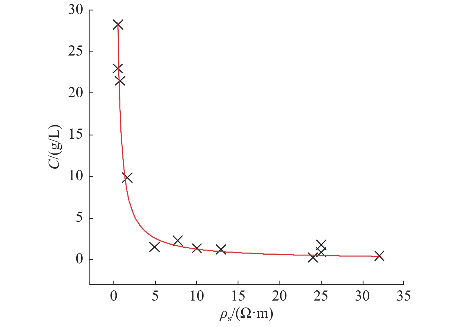
海水入侵等级 I II Ⅲ 海水入侵程度 未入侵 轻度入侵 严重入侵 水体咸化程度 淡水 微咸水 咸水 Cl− /(mg∙L−1) <250 250~1000 >1 000 TDS /(mg∙L−1) <1 000 1 000~3 000 >3 000 ρs /(Ω∙m) 13~150 5~13 <5
下载: 导出CSV
-
[1] Werner A D,Bakker M,Post V E A,et al. Seawater intrusion processes,investigation and management:Recent advances and future challenges[J]. Advances in Water Resources,2013,51:3-26. doi: 10.1016/j.advwatres.2012.03.004
[2] Santucci L,Carol E,Kruse E. Identification of palaeo-seawater intrusion in groundwater using minor ions in a semi-confined aquifer of the Río de la Plata littoral (Argentina)[J]. Science of The Total Environment,2016,566/567:1640-1648. doi: 10.1016/j.scitotenv.2016.06.066
[3] Han D,Currell M J. Delineating multiple salinization processes in a coastal plain aquifer,northern China:hydrochemical and isotopic evidence[J]. Hydrol. Earth Syst. Sci.,2018,22(6):3473-3491. doi: 10.5194/hess-22-3473-2018
[4] 黄 磊,郭占荣. 中国沿海地区海水入侵机理及防治措施研究[J]. 中国地质灾害与防治学报,2008,19(2):118-123. doi: 10.3969/j.issn.1003-8035.2008.02.025
[5] Aslam R A,Shresth A S,Pandey V P. Groundwater vulnerability to climate change:A review of the assessment methodology[J]. Science of The Total Environment,2018,612:853-875. doi: 10.1016/j.scitotenv.2017.08.237
[6] Swartz J H. Resistivity studies of some salt-water boundaries in the Hawaiian Islands[J]. Eos Transactions American Geophysical Union,1937,18(2):387-393. doi: 10.1029/TR018i002p00387
[7] Dahlin T. The development of DC resistivity imaging techniques[J]. Computers and Geosciences,2001,27(9):1019-1029.
[8] Zarroca M,Bach J,Linares R,et al. Electrical methods (VES and ERT) for identifying,mapping and monitoring different saline domains in a coastal plain region (Alt Empordà,Northern Spain)[J]. Journal of Hydrology,2011,409(1):407-422.
[9] Alabjah B,Amraoui F,Chibout M,et al. Assessment of saltwater contamination extent in the coastal aquifers of Chaouia (Morocco) using the electric recognition[J]. Journal of Hydrology,2018,566:363-376. doi: 10.1016/j.jhydrol.2018.09.003
[10] 何玉海. 高密度电法在莱州湾海水入侵调查中的研究与应用[J]. 海洋环境科学,2016,35(2):301-305.
[11] 刘宏伟,黄忠锋,郭 旭,等. 地球物理技术在识别海(咸)水入侵界线中的应用——以莱州湾冲洪积扇区为例[J]. 海洋地质前沿,2016,32(9):58-63.
[12] 韩再生,高恩厚. 洋河、戴河冲洪积平原水文地球化学特征及其成因分析[J]. 勘察科学技术,1988(4):16-20.
[13] 韩再生. 秦皇岛市洋河、戴河滨海平原海水入侵的控制与治理[J]. 现代地质,1990,4(2):105-115.
[14] 鲍 俊. 秦皇岛地区海水入侵的二维数值模拟[D]. 上海: 同济大学, 2005.
[15] 杨吉龙,韩冬梅,肖国强,等. 秦皇岛洋河-戴河冲洪积平原第四系含水层海水入侵机理分析[J]. 地质调查与研究,2009,32(2):144-149. doi: 10.3969/j.issn.1672-4135.2009.02.009
[16] 左文喆,杨燕雄,董军义,等. 秦皇岛洋河-戴河沿海平原海水入侵数值模拟分析[J]. 自然资源学报,2009,24(12):2087-2095. doi: 10.3321/j.issn:1000-3037.2009.12.006
[17] 章 斌,宋献方,郭占荣,等. 用氯和氢氧同位素揭示洋戴河平原地下水的形成演化规律[J]. 环境科学学报,2013,33(11):2965-2972.
[18] Sun Z,Song X,Bu H,et al. Origin of groundwater salinity and hydrochemical processes in an unconfined aquifer:case of Yang-Dai River basin in Qinhuangdao (China)[J]. Environmental Earth Sciences,2016,75(1):1-12. doi: 10.1007/s12665-015-4873-x
[19] 臧文学,刘文军,郭 巨,等. 河北省秦皇岛市海水入侵地质灾害及其防治措施[J]. 中国地质灾害与防治学报,2010,21(4):120-125. doi: 10.3969/j.issn.1003-8035.2010.04.023
[20] 韩再生. 滨海孔隙含水层海水入侵的研究——以秦皇岛市洋河戴河冲洪积平原为例[D]. 北京: 中国地质大学, 1988.
[21] 左文喆. 秦皇岛洋戴河平原海水入侵调查与研究[D]. 北京: 中国地质大学, 2006.
[22] Archie G E. The Electrical Resistivity Log as an Aid in Determining Some Reservoir Characteristics[M].Transactions of American Institute of Mining Metallurgical Engineers, 1942.
[23] 张福振,刁世铭. 电测深方法在滨海平原区水文地质环境调查中的应用[J]. 低碳世界,2014(7):197-198.
[24] 罗文艺,靳孟贵,刘延锋,等. 深圳南山区海水入侵综合研究[J]. 海洋地质动态,2007,23(9):8-12,19. doi: 10.3969/j.issn.1009-2722.2007.09.002
[25] 韩冬梅. 基于环境同位素及水化学的莱州湾海水入侵机理研究[R]. 北京: 中国科学院地理科学与资源研究所, 2009.
[26] De Franco R,Biella G,Tosi L,et al. Monitoring the saltwater intrusion by time lapse electrical resistivity tomography:The Chioggia test site (Venice Lagoon,Italy)[J]. Journal of Applied Geophysics,2009,69(3):117-130.
[27] Goebel M,Pidliseck Y A,Knight R. Resistivity imaging reveals complex pattern of saltwater intrusion along Monterey coast[J]. Journal of Hydrology,2017,551:746-755. doi: 10.1016/j.jhydrol.2017.02.037
-
图(6)
表(2)
计量
- 文章访问数: 1585
- PDF下载数: 54
- 施引文献: 0