

Spatial and temporal variations in vegetation index and its impact factors in the West Liaohe Plain in Inner Mongolia
-
摘要:
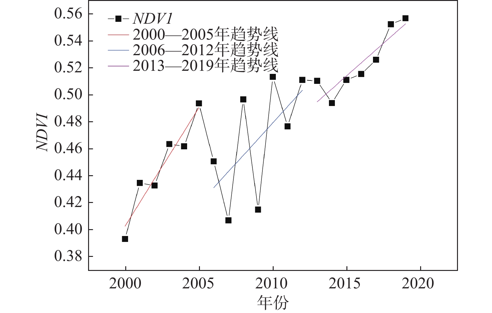
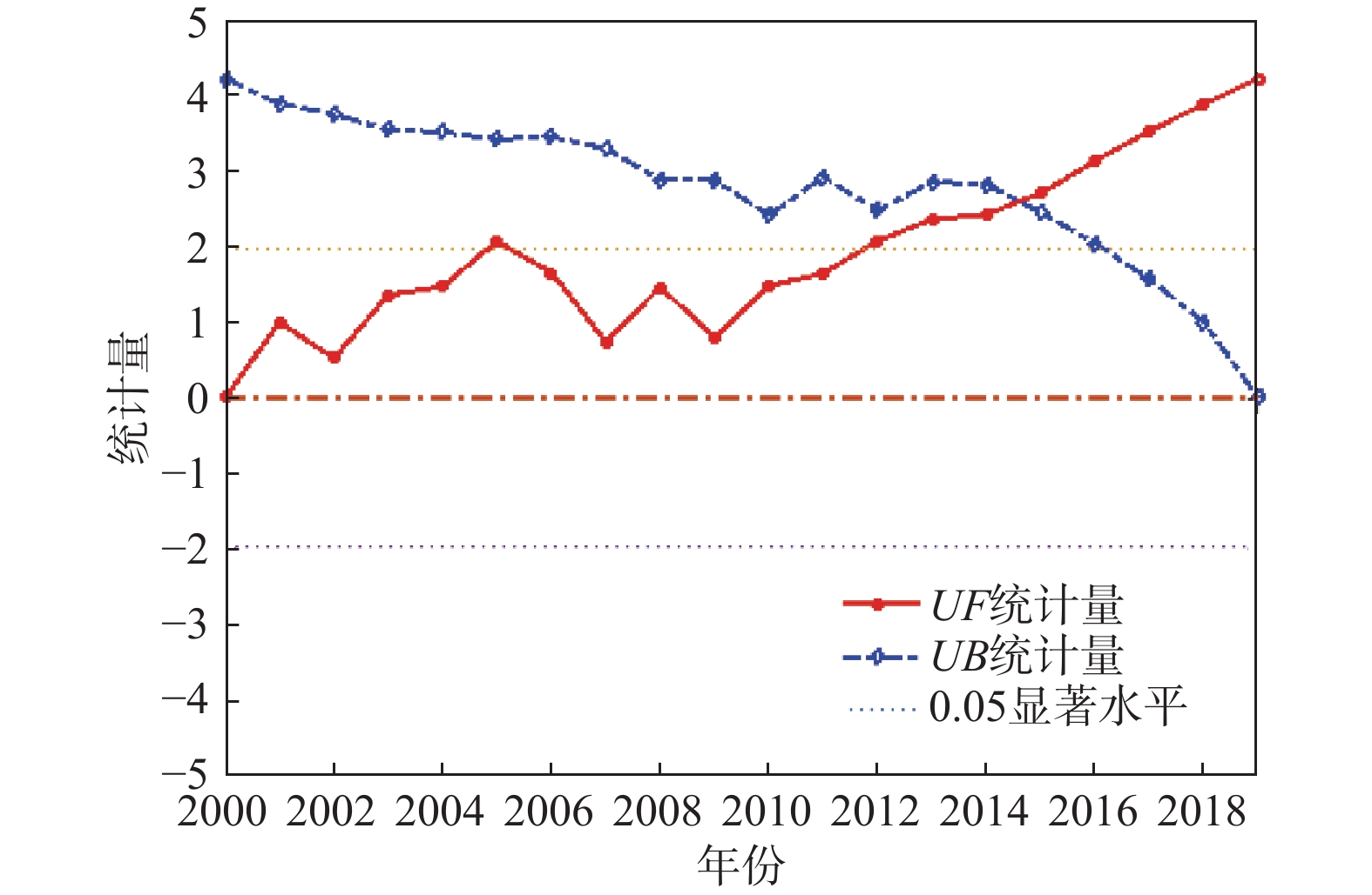
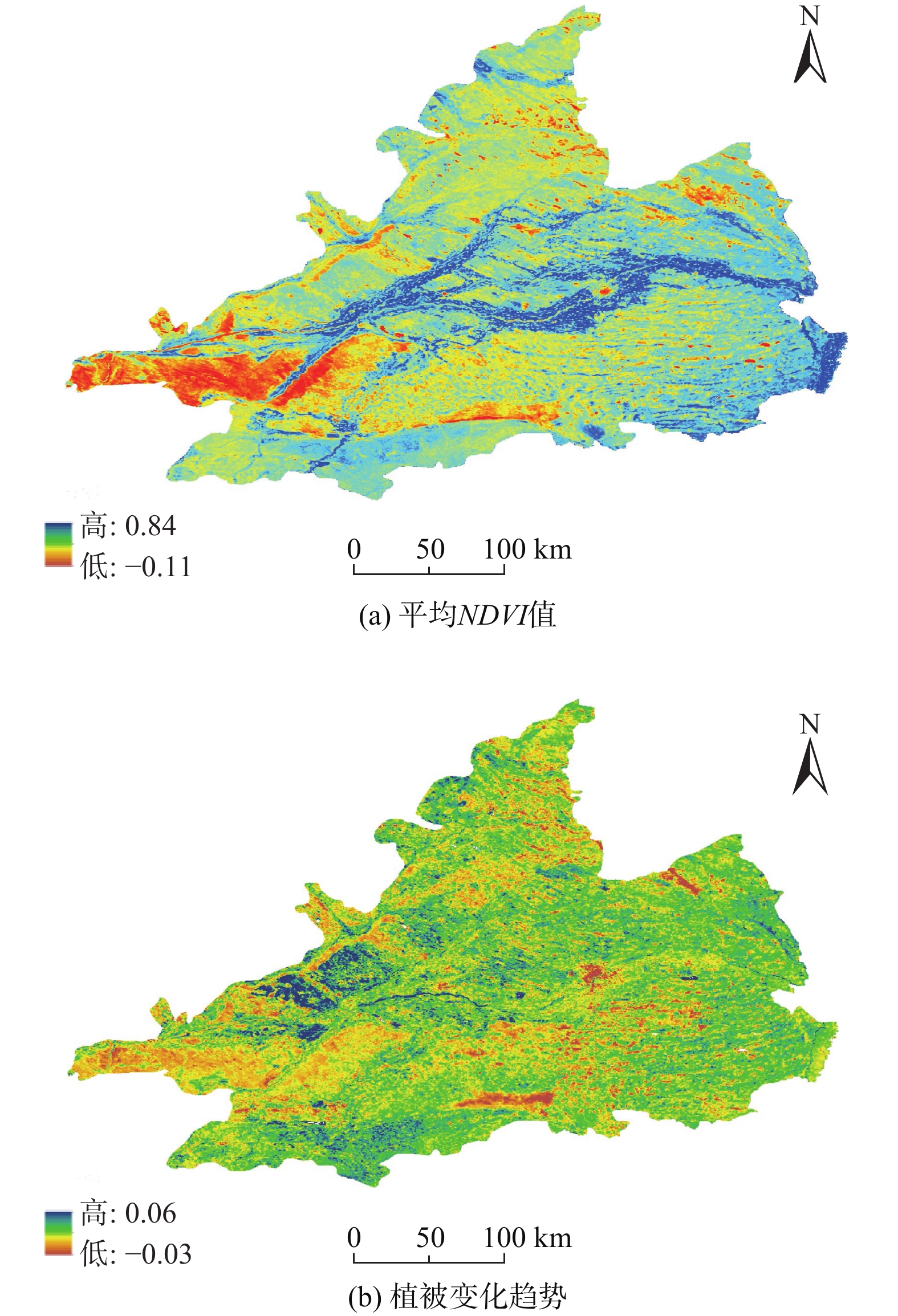
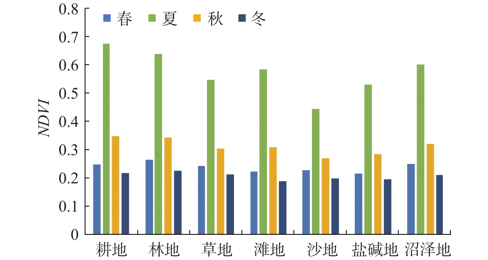
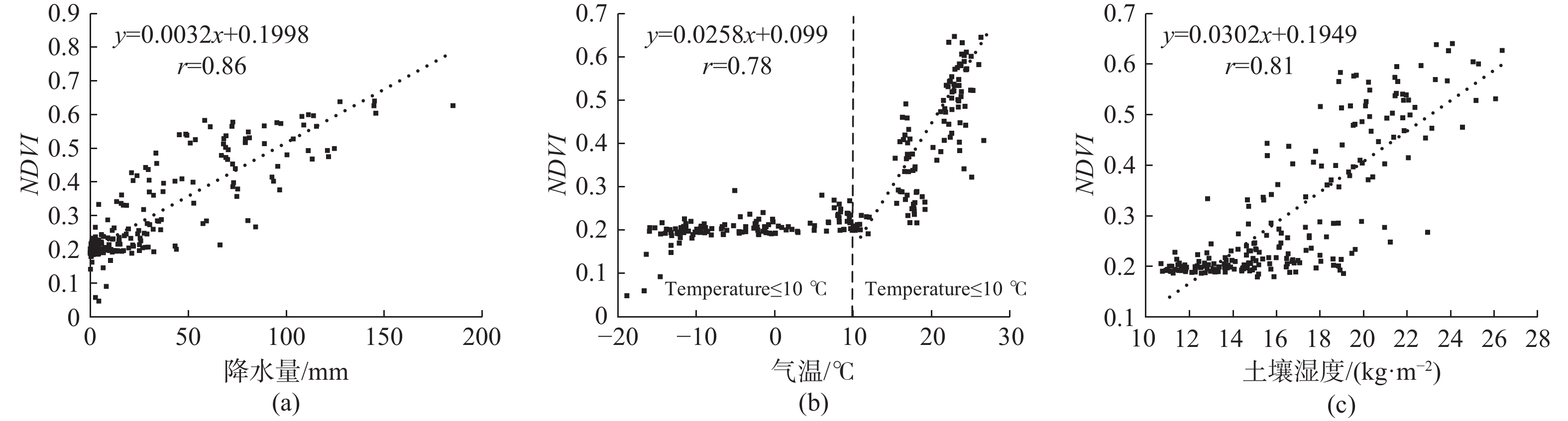
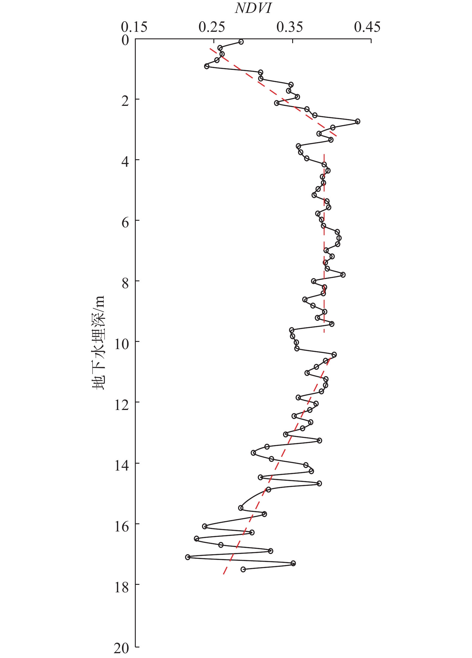
西辽河平原位于我国北方农牧交错带,属半干旱气候,发育科尔沁沙地,生态环境极其脆弱,开展植被指数时空变化及其影响因素研究,对于预测土地退化风险意义重大,可为该流域生态环境保护治理及水资源合理开发利用提供技术支撑。利用2000—2019年MODIS NDVI数据,采用一元线性回归趋势法和Mann-Kendall检验分析了近20年来该地区的植被生长变化趋势及突变情况。从影响植被生长的水热条件出发,分析了NDVI值与气象因素(降水、气温)、土壤湿度、地下水埋深等因子的相关关系;结合人类活动,分析了土地利用类型变化对NDVI值的影响。结果表明:(1)2000—2019年生长季NDVI值整体呈上升趋势,不存在显著突变点,最高值0.56,最低值0.41。(2)NDVI值在空间上呈现“东高西低”的分布特征,不同用地类型的NDVI值由大到小依次为耕地>林地>沼泽地>滩地>草地>盐碱地>沙地。(3)92.5%的区域植被呈增长趋势,7.5%的区域植被呈减少趋势。(4)NDVI值与降水、气温、土壤湿度呈正相关关系,相关系数分别为0.86,0.78,0.81,降水对植被影响最大。(5)最适宜天然植被生长的地下水埋深约为3 m,当地下水埋深大于10 m时,NDVI值会随着埋深的增加剧烈减小。(6)人类活动如土地开垦、植树造林是近20年来NDVI值呈增加趋势的主要原因之一,在一定程度上改善了当地生态环境。
Abstract:The West Liaohe Plain is located in the farming-pasturing ecotone in North China, which lies in the semi-arid region, including the Kerqin Sandy Land, where the ecological environment is extremely fragile. It is of great significance to study the spatio-temporal variation in vegetation index and its influencing factors for predicting the risk of land degradation, which can provide technical support for the protection and management of ecological environment and the rational development and utilization of water resources in the watershed. In this paper, based on the MODIS NDVI data from 2000 to 2019, the univariate linear regression trend method and Mann-Kendall test are used to analyze the vegetation growth trend and mutation in this area in the past 20 years. Considering the water and heat conditions affecting vegetation growth, the correlations between NDVI and meteorological factors (precipitation, air temperature), soil moisture, groundwater depth and other factors are analyzed. In addition, combined with human activities, the impact of land use type change on NDVI is analyzed. The results indicate that (1) the NDVI during the vegetation growing season from 2000 to 2019 shows an overall upward trend, with no significant abrupt change points, the highest value is 0.56 and the lowest value is 0.41. (2) NDVI presents a spatial distribution characteristic of “high in the east and low in the west”. The NDVI of different land use types are in the descending order: cultivated land > forest land > swamp land > flood plain > grassland > saline land > sandy land. (3) The 92.5% of the area shows an increasing trend, and the 7.5% of the area shows a decreasing trend. (4) NDVI is positively correlated with precipitation, temperature and soil moisture, with correlation coefficients of 0.86, 0.80 and 0.81, respectively and precipitation has a greater impact on vegetation. (5) The most suitable groundwater level depth for natural vegetation growth is about 3 m, and when the groundwater level depth is more than 10 m, NDVI will decrease sharply with the increasing groundwater levael depth. (6) Human activities such as land reclamation and afforestation are the main reasons for the increasing trend of NDVI in recent 20 years, which improves the ecological environment to a certain extent.
-
Key words:
- NDVI /
- trend /
- air temperature /
- precipitation /
- soil moisture /
- groundwater depth /
- land use
-

-
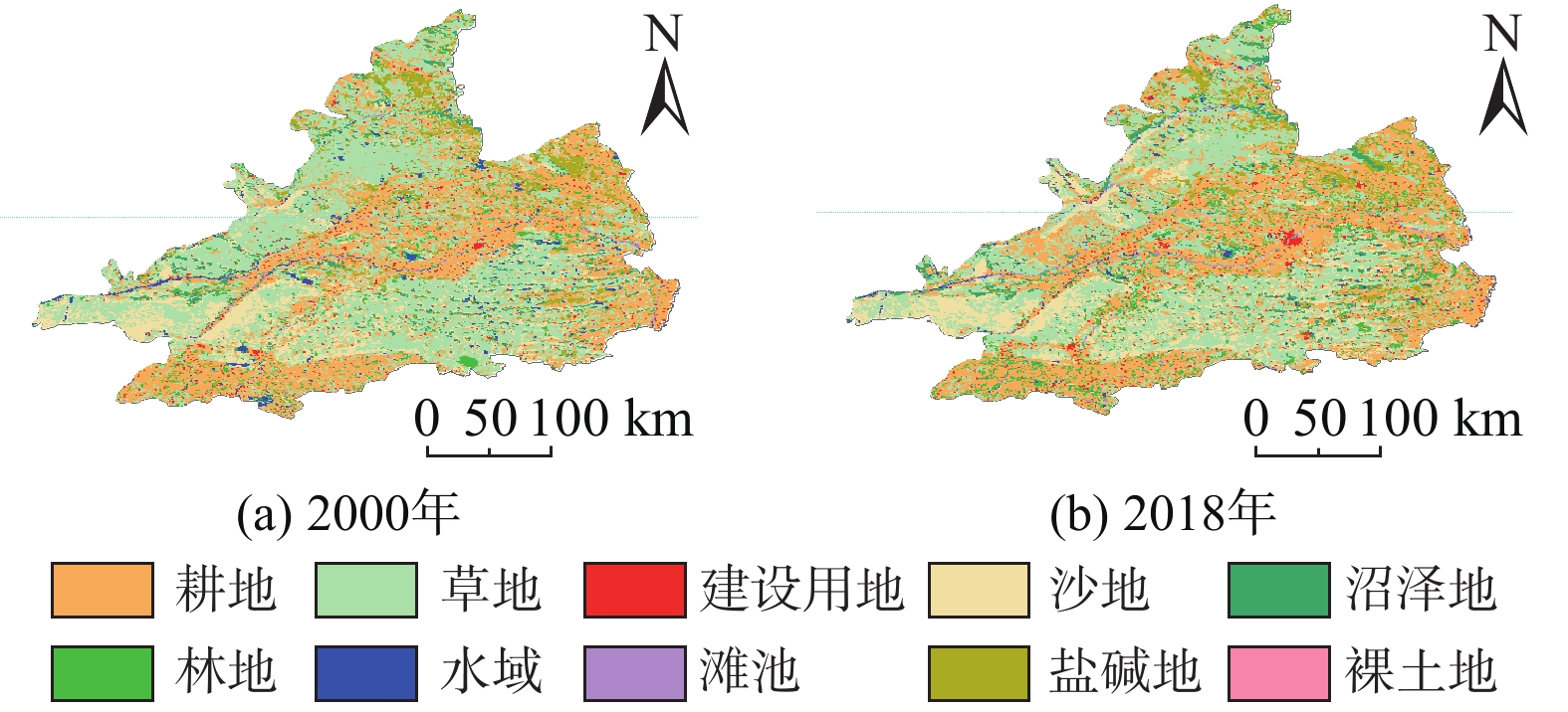
表 1 研究区2000和2018年土地利用类型面积统计
Table 1. Area of different land use types in the study area in 2000 and 2018
/km2 地类 2000年 2018年 变化 耕地 17 186 19 059 1 873 林地 2173 3485 1312 草地 24060 19873 −4187 水域 1152 569 −583 建设用地 1303 1521 218 滩地 306 471 165 沙地 6199 7066 867 盐碱地 3273 3053 −220 沼泽地 1 967 2518 551 裸土地 3 7 4 总计 57622 57622 0  下载: 导出CSV
-
[1] FOLEY J A, LEVIS S, COSTA M H, et al. Incorporating dynamic vegetation cover within global climate models[J]. Ecological Applications,2000,10(6):1620 − 1632. doi: 10.1890/1051-0761(2000)010[1620:IDVCWG]2.0.CO;2
[2] JIN X M, GUO R H, ZHANG Q, et al. Response of vegetation pattern to different landform and water-table depth in Hailiutu River basin, Northwestern China[J]. Environmental Earth Sciences,2014,71(11):4889 − 4898. doi: 10.1007/s12665-013-2882-1
[3] PAN N Q, FENG X M, FU B J, et al. Increasing global vegetation browning hidden in overall vegetation greening: Insights from time-varying trends[J]. Remote Sensing of Environment,2018,214:59 − 72. doi: 10.1016/j.rse.2018.05.018
[4] BETTS R A. Global vegetation and climate: Self-beneficial effects, climate forcings and climate feedbacks[J]. Journal De Physique IV (Proceedings),2004,121:37 − 60. doi: 10.1051/jp4:2004121002
[5] ZHU L K, SOUTHWORTH J. Disentangling the relationships between net primary production and precipitation in southern Africa savannas using satellite observations from 1982 to 2010[J]. Remote Sensing,2013,5(8):3803 − 3825. doi: 10.3390/rs5083803
[6] 刘维, 宋迎波. 2019年秋收作物生长季农业气象条件评价[J]. 中国农业气象,2020,41(3):187 − 190. [LIU Wei, SONG Yingbo. Evaluation of agrometeorological conditions in the growing season of autumn crops in 2019[J]. Chinese Journal of Agrometeorology,2020,41(3):187 − 190. (in Chinese with English abstract) doi: 10.3969/j.issn.1000-6362.2020.03.007
[7] 周爱国, 马瑞, 张晨. 中国西北内陆盆地水分垂直循环及其生态学意义[J]. 水科学进展,2005,16(1):127 − 133. [ZHOU Aiguo, MA Rui, ZHANG Chen. Vertical water cycle and its ecological effect in inland basins, Northwest China[J]. Advances in Water Science,2005,16(1):127 − 133. (in Chinese with English abstract) doi: 10.3321/j.issn:1001-6791.2005.01.023
[8] FABRICANTE I, OESTERHELD M, PARUELO J M. Annual and seasonal variation of NDVI explained by current and previous precipitation across Northern Patagonia[J]. Journal of Arid Environments,2009,73(8):745 − 753. doi: 10.1016/j.jaridenv.2009.02.006
[9] KHAN I A A, ARSALAN M H B, SIDDIQUI M F C, et al. Short-term drought assessment in Pakistan and adjoining areas by remote sensing MODIS-NDVI data: A potential consequence of climate change(Article)[J]. Pakistan Journal of Botany,2016,48(5):1887 − 1892.
[10] 杨泽元, 王文科, 黄金廷, 等. 陕北风沙滩地区生态安全地下水位埋深研究[J]. 西北农林科技大学学报(自然科学版),2006,34(8):67 − 74. [YANG Zeyuan, WANG Wenke, HUANG Jinting, et al. Research on buried depth of eco-safety about groundwater table in the blown-sand region of the Northern Shaanxi Province[J]. Journal of Northwest Sci-Tech University of Agriculture and Forestry (Natural Science Edition),2006,34(8):67 − 74. (in Chinese with English abstract)
[11] 张二勇, 陶正平, 王晓勇, 等. 基于植被结构分析法的生态植被与地下水关系研究—以鄂尔多斯盆地内蒙古能源基地为例[J]. 中国地质,2012,39(3):811 − 817. [ZHANG Eryong, TAO Zhengping, WANG Xiaoyong, et al. A study of vegetation response to groundwater on regional scale in northern Ordos Basin based on structure chart method[J]. Geology in China,2012,39(3):811 − 817. (in Chinese with English abstract) doi: 10.3969/j.issn.1000-3657.2012.03.023
[12] 金晓媚, 王松涛, 夏薇. 柴达木盆地植被对气候与地下水变化的响应研究[J]. 水文地质工程地质,2016,43(2):31 − 36. [JIN Xiaomei, WANG Songtao, XIA Wei. Response of vegetation to variation in climate and groundwater in the Qaidam Basin[J]. Hydrogeology & Engineering Geology,2016,43(2):31 − 36. (in Chinese with English abstract)
[13] 金晓媚, 张强, 杨春杰. 海流兔河流域植被分布与地形地貌及地下水位关系研究[J]. 地学前缘,2013,20(3):227 − 233. [JIN Xiaomei, ZHANG Qiang, YANG Chunjie. Research on vegetation distribution and its relationship with topography and groundwater depth in the Hailiutu River Basin[J]. Earth Science Frontiers,2013,20(3):227 − 233. (in Chinese with English abstract)
[14] 王旭升, 万力, 齐蕊, 等. 鄂尔多斯高原地下水与植被盖度的相互影响[J]. 第四纪研究,2014,34(5):1013 − 1022. [WANG Xusheng, WAN Li, QI Rui, et al. Interactions between groundwater and vegetation coverage in Erdos plateau[J]. Quaternary Sciences,2014,34(5):1013 − 1022. (in Chinese with English abstract) doi: 10.3969/j.issn.1001-7410.2014.05.10
[15] 赵捷, 徐宗学, 牛最荣, 等. 黑河上中游流域植被时空演变规律及其对水热条件的响应特征分析[J]. 北京师范大学学报(自然科学版),2016,52(3):387 − 392. [ZHAO Jie, XU Zongxue, NIU Zuirong, et al. Spatiotemporal variation of vegetation in response to changes in temperature and precipitation in upper and middle reaches of the Heihe River basin: a SPOT NDVI dataset study[J]. Journal of Beijing Normal University (Natural Science),2016,52(3):387 − 392. (in Chinese with English abstract)
[16] 李元春, 葛静, 侯蒙京, 等. 基于CCI-LC数据的甘南和川西北地区土地覆盖类型时空动态分布及草地面积变化驱动力研究[J]. 草业学报,2020,29(3):1 − 15. [LI Yuanchun, GE Jing, HOU Mengjing, et al. A study of the spatiotemporal dynamic of land cover types and the driving forces of grassland area change in Gannan Prefecture and Northwest Sichuan based on CCI-LC data[J]. Acta Prataculturae Sinica,2020,29(3):1 − 15. (in Chinese with English abstract) doi: 10.11686/cyxb2019263
[17] SPRUCE J P, SADER S, RYAN R E, et al. Assessment of MODIS NDVI time series data products for detecting forest defoliation by Gypsy moth outbreaks[J]. Remote Sensing of Environment,2011,115(2):427 − 437. doi: 10.1016/j.rse.2010.09.013
[18] JIN X M, LIU J T, WANG S T, et al. Vegetation dynamics and their response to groundwater and climate variables in Qaidam Basin, China[J]. International Journal of Remote Sensing,2016,37(3):710 − 728. doi: 10.1080/01431161.2015.1137648
[19] RHIF M, BEN ABBES A, MARTINEZ B, et al. An improved trend vegetation analysis for non-stationary NDVI time series based on wavelet transform[J]. Environmental Science and Pollution Research,2021,28(34):46603 − 46613. doi: 10.1007/s11356-020-10867-0
[20] BIANCHI E, VILLALBA R, SOLARTE A. NDVI spatio-temporal patterns and climatic controls over northern Patagonia[J]. Ecosystems,2020,23(1):84 − 97. doi: 10.1007/s10021-019-00389-3
[21] 丁一汇, 张莉. 青藏高原与中国其他地区气候突变时间的比较[J]. 大气科学,2008,32(4):794 − 805. [DING Yihui, ZHANG Li. Intercomparison of the time for climate abrupt change between the Xizang Plateau and other regions in China[J]. Chinese Journal of Atmospheric Sciences,2008,32(4):794 − 805. (in Chinese with English abstract) doi: 10.3878/j.issn.1006-9895.2008.04.08
[22] 刘蓉, 文军, 王欣. 黄河源区蒸散发量时空变化趋势及突变分析[J]. 气候与环境研究,2016,21(5):503 − 511. [LIU Rong, WEN Jun, WANG Xin. Spatial–temporal variation and abrupt analysis of evapotranspiration over the Yellow River source region[J]. Climatic and Environmental Research,2016,21(5):503 − 511. (in Chinese with English abstract)
[23] 高彦春, 王金凤, 封志明. 白洋淀流域气温、降水和径流变化特征及其相互响应关系[J]. 中国生态农业学报,2017,25(4):467 − 477. [GAO Yanchun, WANG Jinfeng, FENG Zhiming. Variation trend and response relationship of temperature, precipitation and runoff in Baiyangdian Lake Basin[J]. Chinese Journal of Eco-Agriculture,2017,25(4):467 − 477. (in Chinese with English abstract)
[24] DENG Y H, WANG S J, BAI X Y, et al. Variation trend of global soil moisture and its cause analysis[J]. Ecological Indicators,2020,110:105939. doi: 10.1016/j.ecolind.2019.105939
-
图(8)
表(1)
计量
- 文章访问数: 1707
- PDF下载数: 162
- 施引文献: 0