

Connotation, layering, mapping and supporting objectives of the integrated survey of ground substrates
-
摘要:
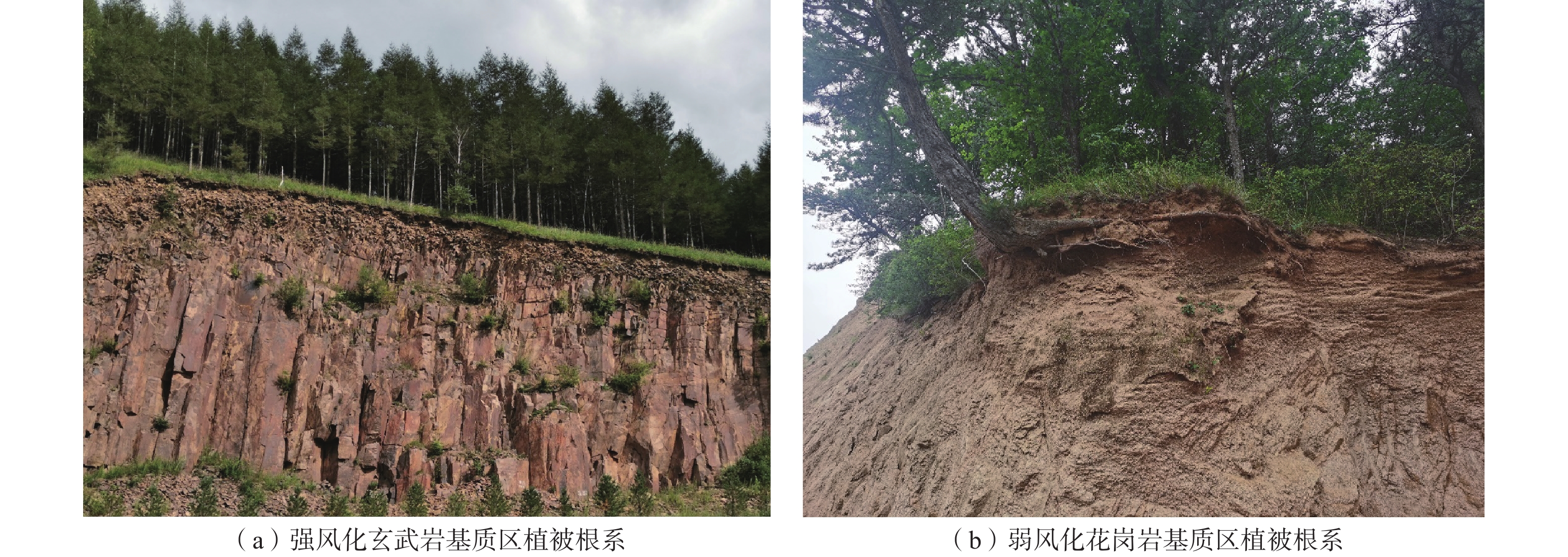
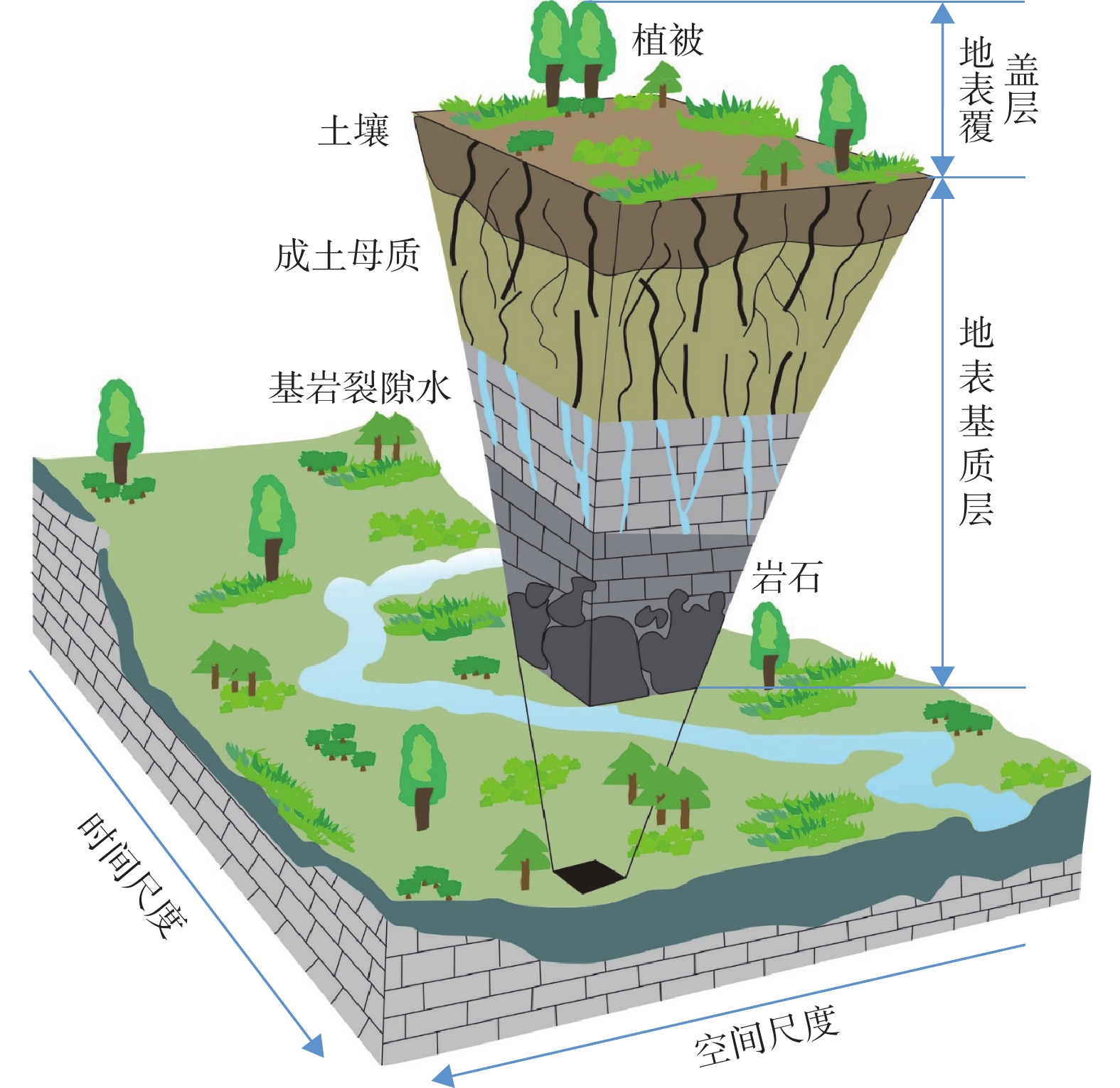
地表基质综合调查评价是支撑自然资源管理和服务宜林宜草、宜耕宜荒的基础性工作。关于地表基质综合调查的理论基础、目标定位、科学内涵、填图方法及分类分层等是目前探索的焦点与热点。文章在近年来承德生态文明示范区地表基质综合调查与多尺度填图的基础上,结合全国不同典型地区地表基质调查研究试点工作,进一步厘清了地表基质的科学内涵与支撑服务目标,建立了地表基质第三级分类方案和填图单元及命名方式,提出了地表基质调查中生产层、生态层和生活层的深度范围,最后从支撑塞罕坝地区植树造林和坝上地区狼毒草生态防治两个案例揭示了地表基质对植被群落的约束作用。研究成果可为深入理解地表基质的科学意义和开展全国范围的地表基质调查、监测、评价、区划提供基础参考。
Abstract:Comprehensive investigation and evaluation of ground substrate is the fundamental work to support suitable forest, grass, farming and wasteland. The guiding theory, target positioning, scientific connotation and mapping unit of comprehensive investigation of ground substrate are the focus and hotspot of current scientific issues. In this paper, based on the comprehensive survey and multi-scale mapping of ground substrate in Chengde Ecological Civilization Demonstration Area in recent years, and combined with the pilot practices of ground substrate survey in different regions, we further clarify the scientific connotation and supporting service objectives of ground substrate, establish the fourth-level classification scheme, mapping unit and naming convention, and proposed the depths range of the production layer, ecological layer and living layer of ground substrate. Finally we take two cases of afforestation and grass degeneration in the Bashang region as examples to reveal the constraining effect of ground substrate on vegetation community. All the above research results will provide a fundamental reference for understanding in-depth of the scientific significance of ground substrate and implementation of survey, monitoring, evaluation and zoning of ground substrate in China.
-
Key words:
- ground substrate /
- theoretical connotation /
- intetrated survey /
- mapping /
- natural resourses
-

-
[1] 自然资源部. 自然资源部关于印发《自然资源调查监测体系构建总体方案》的通知[EB/OL]. (2020-01-17)[2022-04-28]. http://gi.mnr.gov.cn/202001/t20200121_2498506.html
[2] National Research Council. Basic research opportunities in the earth sciences[R]. Washington D C: National Academy Press, 2001: 1–154.
[3] BANWART S A, CHORVER J, GAILLARDET G, et al. Sustaining Earth’s critical zone basic science and interdisciplinary solutions for global challenges[R]. United Kingdom: The University of Sheffield, 2013.
[4] RICHTER D D J,MOBLEY M L. Monitoring earth's critical zone[J]. Science,2009,326(5956):1067 − 1068. doi: 10.1126/science.1179117
[5] ZHANG Ganli,SONG Xiaodong,WU Kening. A classification scheme for Earth’s Critical Zones and its application in China[J]. Science China Earth Sciences,2021,64(10):1709 − 1720. doi: 10.1007/s11430-020-9798-2
[6] 张甘霖,宋效东,吴克宁. 地球关键带分类方法与中国案例研究[J]. 中国科学:地球科学,2021,51(10):1681 − 1692. [ZHANG Ganlin,SONG Xiaodong,WU Kening. A classification scheme for Earth’s Critical Zones and its application in China[J]. Scientia Sinica (Terrae),2021,51(10):1681 − 1692. (in Chinese) doi: 10.1360/SSTe-2020-0249
[7] 刘金涛,韩小乐,刘建立,等. 山坡表层关键带结构与水文连通性研究进展[J]. 水科学进展,2019,30(1):112 − 122. [LIU Jintao,HAN Xiaole,LIU Jianli,et al. Understanding of critical zone structures and hydrological connectivity:A review[J]. Advances in Water Science,2019,30(1):112 − 122. (in Chinese with English abstract) doi: 10.14042/j.cnki.32.1309.2019.01.012
[8] 马腾,沈帅,邓娅敏,等. 流域地球关键带调查理论方法—以长江中游江汉平原为例[J]. 地球科学,2020,45(12):4498 − 4511. [MA Teng,SHEN Shuai,DENG Yamin,et al. Theoretical approaches of survey on Earth’s critical zone in basin:An example from Jianghan Plain,Central Yangtze River[J]. Earth Science,2020,45(12):4498 − 4511. (in Chinese with English abstract)
[9] 郝爱兵,殷志强,彭令,等. 学理与法理和管理相结合的自然资源分类刍议[J]. 水文地质工程地质,2020,47(6):1 − 7. [HAO Aibing,YIN Zhiqiang,PENG Ling,et al. A discussion of the classification of natural resources based on the combination of academic-legal principles and management[J]. Hydrogeology & Engineering Geology,2020,47(6):1 − 7. (in Chinese with English abstract) doi: 10.16030/j.cnki.issn.1000-3665.202009049
[10] 葛良胜,杨贵才. 自然资源调查监测工作新领域:地表基质调查[J]. 中国国土资源经济,2020,33(9):4 − 11. [GE Liangsheng,YANG Guicai. New field of natural resources survey and monitoring:Ground substrate survey[J]. Natural Resource Economics of China,2020,33(9):4 − 11. (in Chinese with English abstract)
[11] 殷志强,秦小光,张蜀冀,等. 地表基质分类及调查初步研究[J]. 水文地质工程地质,2020,47(6):8 − 14. [YIN Zhiqiang,QIN Xiaoguang,ZHANG Shuji,et al. Preliminary study on classification and investigation of surface substrate[J]. Hydrogeology & Engineering Geology,2020,47(6):8 − 14. (in Chinese with English abstract) doi: 10.16030/j.cnki.issn.1000-3665.202010065
[12] 殷志强,卫晓锋,刘文波,等. 承德自然资源综合地质调查工程进展与主要成果[J]. 中国地质调查,2020,7(3):1 − 12. [YIN Zhiqiang,WEI Xiaofeng,LIU Wenbo,et al. Progresses and main achievements of comprehensive geological survey project of natural resources in Chengde[J]. Geological Survey of China,2020,7(3):1 − 12. (in Chinese with English abstract) doi: 10.19388/j.zgdzdc.2020.03.01
[13] 侯红星,张蜀冀,鲁敏,等. 自然资源地表基质层调查技术方法新经验—以保定地区地表基质层调查为例[J]. 西北地质,2021,54(3):277 − 288. [HOU Hongxing,ZHANG Shuji,LU Min,et al. Technology and method of the ground substrate layer survey of natural resources:Taking Baoding area as an example[J]. Northwestern Geology,2021,54(3):277 − 288. (in Chinese with English abstract) doi: 10.19751/j.cnki.61-1149/p.2021.03.026
[14] 侯红星,葛良胜,孙肖,等. 地表基质调查内容及要素–属性指标体系探讨[J]. 自然科学,2021,9(4):433 − 442. [HOU Hongxing,GE Liangsheng,SUN Xiao,et al. Discussion on the contents of ground substrate investigation and the index system of elements and attributes[J]. Open Journal of Natural Science,2021,9(4):433 − 442. (in Chinese with English abstract)
[15] 李响, 周效华, 相振群, 等. 地表基质调查的工作思路刍议: 以海南岛为例[J/OL]. 地质通报. (2021-08-30)[2022-04-20]. https://kns.cnki.net/kcms/detail/11.4648.P.20210827.1805.002.html.
LI Xiang, ZHOU Xiaohua, XIANG Zhenqun, et al. Simply discussion on the work of ground substrate survey: Taking Hainan Island as an example[J/OL]. Geological Bulleitn of China.(2021-08-30)[2022-04-20]. (in Chinese with English abstract)
[16] 王京彬,卫晓锋,张会琼,等. 基于地质建造的生态地质调查方法—以河北省承德市国家生态文明示范区综合地质调查为例[J]. 中国地质,2020,47(6):1611 − 1624. [WANG Jingbin,WEI Xiaofeng,ZHANG Huiqiong,et al. The eco-geological survey based on geological formation,exemplified by integrated geological survey of National Ecological Civilization Demonstration Area in Chengde City,Hebei Province[J]. Geology in China,2020,47(6):1611 − 1624. (in Chinese with English abstract) doi: 10.12029/gc20200601
[17] 卫晓锋,樊刘洋,孙紫坚,等. 河北承德柴白河流域地质建造对植物群落组成的影响[J]. 中国地质,2020,47(6):1869 − 1880. [WEI Xiaofeng,FAN Liuyang,SUN Zijian,et al. The influence of geological formation on plant community composition in Chaibai River Basin,Chengde,Hebei Province[J]. Geology in China,2020,47(6):1869 − 1880. (in Chinese with English abstract) doi: 10.12029/gc20200621
[18] 肖春蕾,聂洪峰,刘建宇,等. 生态-地质作用模式:诠释表生地质过程与生态特征的耦合[J]. 中国地质调查,2021,8(6):9 − 24. [XIAO Chunlei,NIE Hongfeng,LIU Jianyu,et al. Ecological and geological interaction model:The coupling of supergene geological processes and ecological characteristics[J]. Geological Survey of China,2021,8(6):9 − 24. (in Chinese with English abstract) doi: 10.19388/j.zgdzdc.2021.06.02
[19] CHOROVER J,TROCH P A,RASMUSSEN C,et al. How water,carbon,and energy drive critical zone evolution:The jemez santa catalina critical zone observatory[J]. Vadose Zone Journal,2011,10(3):884 − 899. doi: 10.2136/vzj2010.0132
[20] BRISTOL R S, EULISS N H, BOOTH N L, et al. Science strategy for core science systems in the US Geological Survey, 2013—2023[R]. Washington DC: US Geological Survey, 2012: 1-29.
[21] 自然资源部. 自然资源部办公厅关于印发《地表基质分类方案》(试行)的通知[EB/OL]. (2020-12-22)[2022-04-28]. http://gi.mnr.gov.cn/202012/t20201222_2596025.html.
[22] 蔡祖聪. 土壤在植物多样性形成中的作用及其研究意义[J]. 土壤学报,2022,59(1):1 − 9. [CAI Zucong. The role of soil in the formation of plant biodiversity and its research significance[J]. Acta Pedologica sinica,2022,59(1):1 − 9. (in Chinese with English abstract)
-
 下载:
下载:


图(5)
计量
- 文章访问数: 1814
- PDF下载数: 126
- 施引文献: 0