Analysis of the distribution characteristics and influencing factors of geological hazards in Zhejiang Province based on fractal theory
-
摘要:
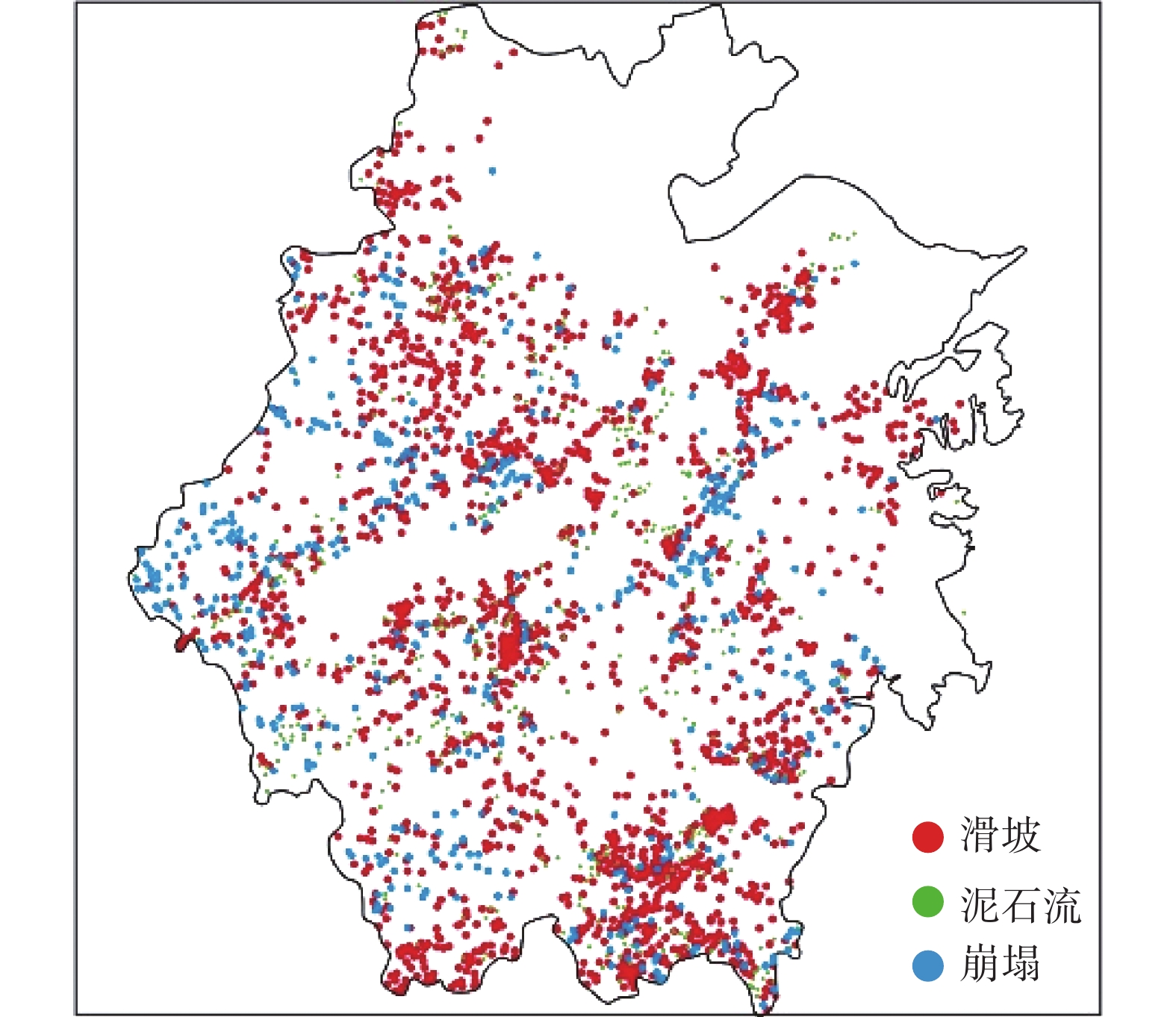
在浙江省地质灾害空间分布特征研究中引入了多重分形方法,基于分形理论研究地质灾害分布的影响因素。研究结果表明:浙江省地质灾害空间分布具有明显的分形特征,西北和东南地区发育较强烈;浙江省地质灾害空间分布与水系分布、降水量、地形坡度、坡高、地层岩性、道路分布及地形地貌有关,其中在降雨量为2232~2565 mm、坡度为25°~35°范围内、坡高为500~1000 m范围内和侏罗系地层范围内,崩塌、滑坡、泥石流灾害发育明显,在山地地形范围内地质灾害易发生。浙江省的道路分布中,省道分布对地质灾害发育的影响比较大;浙江省钱塘江水系和瓯江水系比较复杂,且对地质灾害发育的影响比较大。研究成果进一步明确了浙江省地质灾害分布特征及主要影响因素影响规律,对灾害防治开展具有指导参考意义。
Abstract:The multifractal method is introduced in the study of the spatial distribution characteristics of geological hazards in Zhejiang Province, and the influencing factors of geological hazards distribution are studied based on the fractal theory. The research results show that the spatial distribution of geological hazards in Zhejiang Province has obvious fractal characteristics, and the northwest and southeast regions are more developed; The terrain is related to the topography. Among them, within the range of rainfall of 2232−2565 mm, the slope of 25°−35°, the slope of 500−1000 m, and Jurassic strata, collapse, landslide, and debris flow are obviously developed. Internal geological hazards are prone to occur. In the distribution of roads in Zhejiang Province, the distribution of provincial roads has a greater impact on the development of geological hazards; the Qiantang River and Oujiang River systems in Zhejiang Province are more complex and have a greater impact on the development of geological hazards. The research results further clarified the distribution characteristics of geological hazards in Zhejiang Province and the influence laws of main influencing factors, which have guiding and reference significance for disaster prevention and control.
-

-
表 1 各类地质灾害点分布的拟合函数及分维值
Table 1. Fitting function and fractal dimension value of the spatial distribution of various disaster types
灾害类型 拟合函数 分维值 相关系数 总地质灾害 y = −1.6924x + 10.484 1.6924 0.9996 滑坡 y = −1.646x + 10.248 1.6460 0.9994 崩塌 y = −1.4984x + 9.4427 1.4984 0.9973 泥石流 y = −1.4132x + 9.0765 1.4132 0.9948 表 2 2010—2018年浙江省各市地质灾害发生次数
Table 2. The number of geological hazards in cities in Zhejiang Province from 2010 to 2018
灾害类型
地区滑坡/次 崩塌/次 泥石流/次 总计/次 杭州市 231 280 95 606 宁波市 239 192 62 493 温州市 567 114 74 755 嘉兴市 49 46 12 107 湖州市 34 117 10 161 绍兴市 203 151 29 383 金华市 69 47 9 125 衢州市 367 114 45 529 舟山市 21 22 0 43 台州市 24 19 4 47 丽水市 375 241 76 692 表 3 不同水系地质灾害分布分维值
Table 3. Fractal dimension value of the distribution of geological hazards in different water systems
分维值
八大水系水系 地质灾害 分维值 相关系数 分维值 相关系数 苕溪水系 1.3818 0.9437 1.2089 0.9496 运河水系 1.1684 0.9368 0 0 甬江水系 1.2089 0.9923 0.8919 0.9225 钱塘江水系 1.4686 0.9911 1.4204 0.9896 椒江水系 1.0689 0.9722 0.9489 0.9827 瓯江水系 1.4012 0.9941 1.3569 0.9942 飞云江水系 0.9832 0.9394 0.9610 0.9428 鳌江水系 0.7807 0.9347 0.7621 0.9389 表 4 不同降雨量范围内地质灾害分布分维值
Table 4. Fractal dimension value of geological hazard distribution in different rainfall ranges
地质灾害
降雨量/mm分维值 崩塌 滑坡 泥石流 1231~1565 0 0.6229 0.4937 1565~1898 1.0411 1.2517 0.92 1898~2232 1.284 1.449 1.2211 2232~2565 1.3402 1.5138 1.3203 表 5 不同坡度范围内地质灾害分布分维值
Table 5. Fractal dimension value of geological hazards distribution in different slope ranges
地质灾害
坡度/(°)分维值 崩塌 滑坡 泥石流 ≤8 0.6281 0.9113 0.5231 8~15 1.0259 1.2558 1.0099 15~25 1.1265 1.3646 1.0983 25~35 1.1817 1.4418 1.1548 >35 0.9045 1.0422 1.0401 表 6 不同海拔高度范围内地质灾害分布分维值
Table 6. Fractal dimension value of geological hazards distribution in different altitude ranges
地质灾害
坡高/m分维值 崩塌 滑坡 泥石流 0~300 0.7585 1.0925 0.7176 300~500 1.1460 1.3961 1.1182 500~1000 1.2716 1.4482 1.1844 1000~1500 1.0448 1.2646 1.0630 表 7 不同地层岩性分布分维值
Table 7. Fractal dimension value of different strata lithology distribution
分维值
地层分维值 相关系数 中新生代 第四系 1.5007 0.9995 古近系+新近系 1.1900 0.9806 白垩系 1.4483 0.9977 侏罗系 1.6684 0.9999 泥盆-三叠系 三叠系 1.4223 0.9968 二叠系 1.3683 0.9875 石炭系 1.1159 0.9751 泥盆系 1.1590 0.9964 震旦志留系 志留系 0.9884 0.9899 奥陶系 1.0771 0.9935 寒武系 1.2494 0.9963 震旦系 0.8793 0.9900 表 8 不同道路分布分维值
Table 8. The distribution fractal dimension value of the different road
类型 拟合函数 分维值 相关系数 高速 y = −1.4894x + 9.4108 1.4894 0.9993 铁路 y= −1.2661x + 8.2485 1.2661 0.9978 国道 y = −1.4065x + 8.9952 1.4065 0.9947 省道 y = −1.5106x + 9.5783 1.5106 0.9967 全部道路 y = −1.6433x + 10.232 1.6433 0.9993 表 9 不同地形地貌范围内地质灾害分布分维值
Table 9. Fractal dimension value of geological hazards distribution in different topographic and landform ranges
地质灾害
地形地貌分维值 崩塌 滑坡 泥石流 总地质灾害 山地 1.4001 1.6284 1.3874 1.6465 丘陵 0.5138 0.9154 0.4837 0.9306 台地 0.2211 0.7585 0.117 0.6496 平原 0.9666 1.2423 0.7925 1.2922 洼地 − − − − -
[1] 潘懋, 李铁锋. 灾害地质学[M]. 北京: 北京大学出版社, 2002
PAN Mao, LI Tiefeng. Disaster geology[M]. Beijing: Peking University Press, 2002. (in Chinese)
[2] 段晨玉,张以晨,张继权,等. 基于GIS的地质灾害风险预警系统设计[J]. 灾害学,2022,37(1):199 − 204. [DUAN Chenyu,ZHANG Yichen,ZHANG Jiquan,et al. Design of geological disaster risk early warning system based on GIS[J]. Journal of Catastrophology,2022,37(1):199 − 204. (in Chinese with English abstract) doi: 10.3969/j.issn.1000-811X.2022.01.033
[3] 江南. 盒维数概念的历史演变[J]. 自然辩证法研究,2020,36(10):84 − 90. [JIANG Nan. The historical evolution of the concept of box dimension[J]. Studies in Dialectics of Nature,2020,36(10):84 − 90. (in Chinese with English abstract) doi: 10.19484/j.cnki.1000-8934.2020.10.015
[4] 周琰嵩. 云南省嵩明县地质灾害发育规律与致灾因素分析[D]. 北京: 中国地质大学(北京), 2018
ZHOU Yansong. Analysis on the development law and disaster factors of geological disasters in Songming County, Yunnan Province[D]. Beijing: China University of Geosciences, 2018. (in Chinese with English abstract)
[5] 菊春燕,贾永刚,潘玉英,等. 基于分形理论的旅游景区地质灾害危险性评估—以青岛崂山为例[J]. 自然灾害学报,2013,22(6):85 − 95. [JU Chunyan,JIA Yonggang,PAN Yuying,et al. Geohazard assessment of tourist attractions based on fractal theory:A case study of Qingdao Laoshan[J]. Journal of Natural Disasters,2013,22(6):85 − 95. (in Chinese with English abstract)
[6] 桂蕾,殷坤龙. 基于多重分形理论的滑坡地表监测位移分析[J]. 中南大学学报(自然科学版),2014,45(11):3908 − 3914. [GUI Lei,YIN Kunlong. Analysis of landslide surface monitoring displacement based on multi-fractal theory[J]. Journal of Central South University (Science and Technology),2014,45(11):3908 − 3914. (in Chinese with English abstract)
[7] 姜恩三,任光明,陈锦涛. 四川省普格县地质灾害发育的分形特征[J]. 中国地质灾害与防治学报,2016,27(3):122 − 126. [JIANG Ensan,REN Guangming,CHEN Jintao. The fractal characteristics of the geological hazards development of Pugh County Sichuan Province[J]. The Chinese Journal of Geological Hazard and Control,2016,27(3):122 − 126. (in Chinese with English abstract) doi: 10.16031/j.cnki.issn.1003-8035.2016.03.18
[8] 王森,许强,罗博宇,等. 基于分形理论的南江县滑坡敏感性分析与易发性评价[J]. 水文地质工程地质,2017,44(3):119 − 126. [WANG Sen,XU Qiang,LUO Boyu,et al. Vulnerability analysis and susceptibility evaluation of landslides based on fractal theory in Nanjiang County[J]. Hydrogeology & Engineering Geology,2017,44(3):119 − 126. (in Chinese with English abstract)
[9] 王潇,刘婷,姚昆,等. 分形理论在达州市达川区滑坡灾害研究中的应用[J]. 人民长江,2019,50(2):144 − 150. [WANG Xiao,LIU Ting,YAO Kun,et al. Application of fractal theory to landslide disaster research in Dachuan District,Dazhou City[J]. Yangtze River,2019,50(2):144 − 150. (in Chinese with English abstract) doi: 10.16232/j.cnki.1001-4179.2019.02.025
[10] 乔朋腾. 吕梁山区滑坡崩塌发育规律及易发性研究[D]. 西安: 长安大学, 2019
QIAO Pengteng. Study on development regularity and susceptibility of landslide and collapse in Lv-Liang Mountains[D]. Xi’an: Changan University, 2019. (in Chinese with English abstract)
[11] 陶洁. 基于分形理论和显著性分析的滑坡提取研究[D]. 北京: 中国地质大学(北京), 2020
TAO Jie. Study on extraction of landslide based on fractal theory and saliency analysis[D]. Beijing: China University of Geosciences, 2020. (in Chinese with English abstract)
[12] 都来瀚. 基于分形理论的岩质滑坡失稳判据与形变预测研究[D]. 北京: 中国地质大学(北京), 2020
DU Laihan. Study about instability criterion and deformation prediction of rock slope based on fractal theory[D]. Beijing: China University of Geosciences, 2020. (in Chinese with English abstract)
[13] 史兴旺,管新邦,边筠. 云南省滑坡灾害分形特征研究与分形评价模型探讨[J]. 自然灾害学报,2021,30(3):209 − 216. [SHI Xingwang,GUAN Xinbang,BIAN Yun. Study on fractal characteristics and fractal evaluation model of landslide hazards in Yunnan Province[J]. Journal of Natural Disasters,2021,30(3):209 − 216. (in Chinese with English abstract)
[14] 孔庆鸽. 分形插值函数的盒维数及应用[D]. 杭州: 浙江大学, 2018
KONG Qingge. Box dimension and applications of fractal interpolation functions[D]. Hangzhou: Zhejiang University, 2018. (in Chinese with English abstract)
[15] 曹俊贤,宋春林. 分形维数的计算及改进[J]. 信息技术与信息化,2017(10):19 − 23. [CAO Junxian,SONG Chunlin. Calculation and improvement of the fractal dimension[J]. Information Technology and Informatization,2017(10):19 − 23. (in Chinese with English abstract) doi: 10.3969/j.issn.1672-9528.2017.10.001
[16] 张磊,陈张建,黄丽. 浙江省地质灾害防治管理平台设计与实现[J]. 中国地质灾害与防治学报,2020,31(2):102 − 110. [ZHANG Lei,CHEN Zhangjian,HUANG Li. Design and implementation of Zhejiang Province geological disaster prevention management platform[J]. The Chinese Journal of Geological Hazard and Control,2020,31(2):102 − 110. (in Chinese with English abstract) doi: 10.16031/j.cnki.issn.1003-8035.2020.02.14
[17] 浙江省自然资源与环境统计年鉴(2019)[M]. 北京: 中国统计出版社, 2019
Zhejiang Province natural resources and environment statistical yearbook (2019)[M]. Beijing: China Statistics Press, 2019. (in Chinese)
[18] 祝杨菲,梁勤欧,林德根. 浙江省滑坡地质灾害风险地图制图综合研究[J]. 国土与自然资源研究,2019(3):34 − 41. [ZHU Yangfei,LIANG Qinou,LIN Degen. Research on mapping of landslide geological hazard risk map in Zhejiang region,China[J]. Territory & Natural Resources Study,2019(3):34 − 41. (in Chinese with English abstract) doi: 10.3969/j.issn.1003-7853.2019.03.010
[19] 冯杭建,周爱国,唐小明,等. 浙江省泥石流灾害发育分布规律及区域预报[J]. 地球科学,2016,41(12):2088 − 2099. [FENG Hangjian,ZHOU Aiguo,TANG Xiaoming,et al. Development and distribution characteristics of debris flow in Zhejiang Province and its regional forecast[J]. Earth Science,2016,41(12):2088 − 2099. (in Chinese with English abstract)
[20] 王若谷. 露天煤矿排土场地貌多重分形特征及其与岩土侵蚀关系[D]. 北京: 中国地质大学(北京), 2019
WANG Ruogu. The relationship between soil erosion and multi-fractal parameters of landform in an opencast coal-mine dump in a loess area of China[D]. Beijing: China University of Geosciences, 2019. (in Chinese with English abstract)
-


 下载:
下载:

