

Time-series monitoring of two-dimensional deformation of Tongwei loess landslide in Gansu Province
-
摘要:
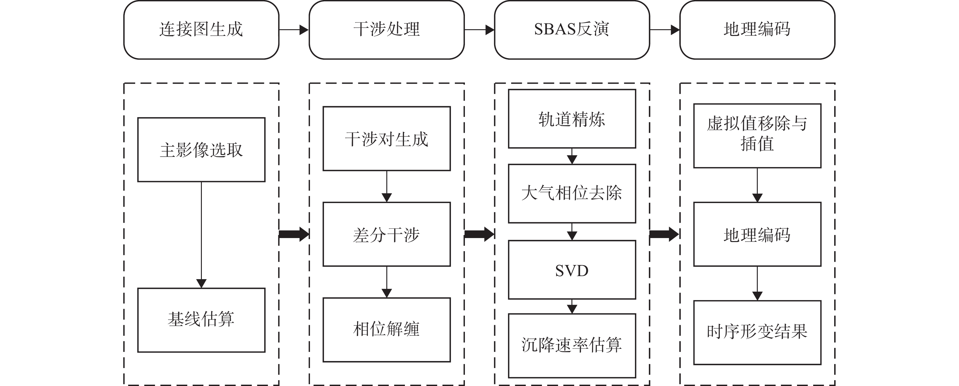
时间序列合成孔径雷达干涉测量技术能有效反应滑坡形变过程。2019年9月14日,甘肃省通渭县发生山体滑坡,但该滑坡灾前是否已经发生缓慢形变以及滑坡原因值得追溯和探讨。文中基于欧洲航天局发布的哨兵一号升/降轨数据,利用SBAS-InSAR技术分析甘肃通渭滑坡灾前二维形变特征以及滑动的因素。结果表明,2018年9月—2019年9月此滑坡存在连续形变,且随时间推移形变量不断增大,因此该滑坡为非突发型事件。在滑坡发生前,垂直向与东西向上最大累计形变量分别达18.25 mm和32.85 mm。基于二维时间序列结果进行距离分析与降雨量对比分析,显示苦水河与降雨量是该滑坡发生的两大诱因。该InSAR追溯结果进一步验证了星载雷达干涉测量技术在滑坡探测方面的应用潜力,是滑坡灾前识别、预警、防灾等减灾工作的有力工具。
Abstract:The time-series synthetic aperture radar interferometry can reflect the deformation process of landslides effectively. On September 14, 2019, a landslide occurred in Tongwei County, Gansu Province. However, whether the landslide had occurred slow deformation before the disaster and the cause of the landslide are worth tracing and discussing. In this paper, based on the Sentinel1-A ascent/descent data released by the European Space Agency (ESA), the two-dimensional deformation characteristics and sliding factors before the Tongwei landslide in Gansu Province were analyzed by SBAS-InSAR technique. The results show that there is continuous deformation of the landslide from September 2018 to September 2019, and the deformation variable increases with the passage of time, so the landslide is not a sudden event. Before the landslide occurred, the maximum cumulative shape variables in the vertical direction and east-west direction were 18.25 mm and 32.85 mm respectively. Based on the results of the two-dimensional time series, the distance analysis and the comparative analysis of rainfall show that the Kushui River and rainfall are the two main inducements of the landslide. The InSAR traceback results further verify the application potential of satellite-borne radar interferometry technology in landslide detection, which is a powerful tool for landslide identification and early warning, disaster prevention, and mitigation.
-
Key words:
- InSAR /
- sentinel image /
- 2D deformation /
- precipitation /
- Tongwei County Gansu Province
-

-
表 1 Sentinel-1A卫星SAR数据主要参数
Table 1. Main parameters of Sentinel-1A satellite SAR data
主要参数 升轨 降轨 波段 C C 雷达波长/cm 5.6 5.6 空间分辨率/m 5×20 5×20 入射角/(°) 33.0 36.2 获取日期 2018年9月1日—
2019年9月8日2018年9月6日—
2019年9月13日 下载: 导出CSV
-
[1] 叶伟林,康丽娟,安亚鹏,等. 甘肃永靖焦家村上庄2·28滑坡特点及成因分析[J]. 兰州大学学报(自然科学版),2021,57(3):369 − 375. [YE Weilin,KANG Lijuan,AN Yapeng,et al. Analysis of the characteristics and causes of Jiaojia landslide on February 28,2019 in Yongjing County,Gansu Province[J]. Journal of Lanzhou University (Natural Sciences),2021,57(3):369 − 375. (in Chinese with English abstract)
[2] 王志旺,李端有. 3S技术在滑坡监测中的应用[J]. 长江科学院院报,2005,22(5):33 − 36. [WANG Zhiwang,LI Duanyou. Application of 3S technology in landslide monitoring[J]. Journal of Yangtze River Scientific Research Institute,2005,22(5):33 − 36. (in Chinese with English abstract) doi: 10.3969/j.issn.1001-5485.2005.05.010
[3] 周定义, 左小清, 喜文飞, 等. 基于SBAS-InSAR技术的深切割高山峡谷区滑坡灾害早期识别[J/OL]. 中国地质灾害与防治学报: 1 − 9 [2021-12-01]
ZHOU Dingyi, ZUO Xiaoqing, XI Wenfei, et al. Early identification of landslide disaster in deep cut alpine valley based on Sbas-insAR technology[J/OL]. The Chinese Journal of Geological Hazard and Control: 1 − 9 [2021-12-01].(in Chinese with English abstract)
[4] 陈有东, 张立峰, 何毅, 等. 升降轨Sentinel-1A时序InSAR的中川国际机场地表形变监测与分析[J/OL]. 工程地质学报: 1 − 19 [2021-12-01]
CHEN Youdong, ZHANG Lifeng, HE Yi, et al. Monitoring and Analysis of surface deformation in Zhongchuan International Airport based on Sentinel-1A Time-series InSAR[J/OL]. Journal of Engineering Geology: 1 − 19 [2021-12-01].(in Chinese with English abstract)
[5] DONG J,LIAO M S,XU Q,et al. Detection and displacement characterization of landslides using multi-temporal satellite SAR interferometry:A case study of Danba County in the Dadu River basin[J]. Engineering Geology,2018,240:95 − 109. doi: 10.1016/j.enggeo.2018.04.015
[6] 戴可人,卓冠晨,许强,等. 雷达干涉测量对甘肃南峪乡滑坡灾前二维形变追溯[J]. 武汉大学学报(信息科学版),2019,44(12):1778 − 1786. [DAI Keren,ZHUO Guanchen,XU Qiang,et al. Tracing the pre-failure two-dimensional surface displacements of Nanyu landslide,Gansu Province with radar interferometry[J]. Geomatics and Information Science of Wuhan University,2019,44(12):1778 − 1786. (in Chinese with English abstract) doi: 10.13203/j.whugis20190092
[7] 侯燕军,周小龙,石鹏卿,等. “空-天-地”一体化技术在滑坡隐患早期识别中的应用:以兰州普兰太公司滑坡为例[J]. 中国地质灾害与防治学报,2020,31(6):12 − 20. [HOU Yanjun,ZHOU Xiaolong,SHI Pengqing,et al. Application of “Air-Space-Ground” integrated technology in early identification of landslide hidden danger:Taking Lanzhou Pulantai Company Landslide as an example[J]. The Chinese Journal of Geological Hazard and Control,2020,31(6):12 − 20. (in Chinese with English abstract)
[8] 吴正军, 丁保艳, 邵东桥. 甘肃省定西市通渭县常河镇滑坡灾害应急调查报告[R]. 兰州: 甘肃地质灾害防治工程勘查设计院, 2019
WU Zhengjun, DING Baoyan, SHAO Dongqiao. Emergency investigation report of landslide disaster in Changhe Town, Tongwei County, Dingxi City, Gansu Province[R]. Lanzhou: Gansu Geological Hazard Prevention Engineering Exploration and Design Institute, 2019. (in Chinese)
[9] 王浩杰,孙萍,韩帅,等. 甘肃通渭“9·14”常河滑坡成因机理[J]. 现代地质,2021,35(3):732 − 743. [WANG Haojie,SUN Ping,HAN Shuai,et al. Failure mechanism of the changhe landslide on September 14,2019 in Tongwei,Gansu[J]. Geoscience,2021,35(3):732 − 743. (in Chinese with English abstract)
[10] SUN P,LI R J,JIANG H,et al. Earthquake-triggered landslides by the 1718 Tongwei earthquake in Gansu Province,northwest China[J]. Bulletin of Engineering Geology and the Environment,2017,76(4):1281 − 1295. doi: 10.1007/s10064-016-0949-4
[11] HE Y,WANG W H,YAN H W,et al. Characteristics of surface deformation in Lanzhou with sentinel-1A TOPS[J]. Geosciences,2020,10(3):99. doi: 10.3390/geosciences10030099
[12] KOUHARTSIOUK D,PERDIKOU S. The application of DInSAR and Bayesian statistics for the assessment of landslide susceptibility[J]. Natural Hazards,2021,105(3):2957 − 2985. doi: 10.1007/s11069-020-04433-7
[13] 张毅. 基于InSAR技术的地表变形监测与滑坡早期识别研究—以白龙江流域中游为例[D]. 兰州: 兰州大学, 2018
ZHANG Yi. Detecting ground deformation and investigating landslides using InSAR technique: Taking middle reach of Bailong River basin as an example[D]. Lanzhou: Lanzhou University, 2018. (in Chinese with English abstract)
[14] BERARDINO P,FORNARO G,LANARI R,et al. A new algorithm for surface deformation monitoring based on small baseline differential SAR interferograms[J]. IEEE Transactions on Geoscience and Remote Sensing,2002,40(11):2375 − 2383. doi: 10.1109/TGRS.2002.803792
[15] WANG W H,HE Y,ZHANG L F,et al. Analysis of surface deformation and driving forces in Lanzhou[J]. Open Geosciences,2020,12(1):1127 − 1145. doi: 10.1515/geo-2020-0128
[16] HE Y,CHEN Y D,WANG W H,et al. TS-InSAR analysis for monitoring ground deformation in Lanzhou New District,the loess Plateau of China,from 2017 to 2019[J]. Advances in Space Research,2021,67(4):1267 − 1283. doi: 10.1016/j.asr.2020.11.004
[17] 胡俊,李志伟,朱建军,等. 融合升降轨SAR干涉相位和幅度信息揭示地表三维形变场的研究[J]. 中国科学(地球科学),2010,40(3):307 − 318. [HU Jun,LI Zhiwei,ZHU Jianjun,et al. Inferring three-dimensional surface displacement field by combining SAR interferometric phase and amplitude information of ascending and descending orbits[J]. China Earth (Scientia Sinica),2010,40(3):307 − 318. (in Chinese with English abstract) doi: 10.1360/zd2010-40-3-307
[18] 石固林, 陈强, 刘先文, 等. 联合升降轨Sentinel-1A数据监测桃坪乡古滑坡沿坡向的形变速度场[J/OL]. 工程地质学报: 1 − 12 [2021-01-24]
SHI Gulin, CHEN Qiang, LIU Xianwen, et al. Deformation velocity field in the aspect direction of an ancient landslide in Taoping Village derived from ascending and descending Sentinel-1A data[J/OL]. Journal of Engineering Geology: 1 − 12 [2021-01-24].(in Chinese with English abstract)
[19] 程前,王华斌,汪韬阳,等. 基于RFM模型的叠掩区域定位方法[J]. 航天返回与遥感,2019,40(5):95 − 105. [CHENG Qian,WANG Huabin,WANG Taoyang,et al. Positioning method for layover area based on RFM model[J]. Spacecraft Recovery & Remote Sensing,2019,40(5):95 − 105. (in Chinese with English abstract) doi: 10.3969/j.issn.1009-8518.2019.05.011
[20] 周吕,李佳豪,王成,等. 基于时序InSAR的上海地区2018—2020地铁沿线沉降监测分析[J]. 大地测量与地球动力学,2021,41(11):1177 − 1182. [ZHOU Lyu,LI Jiahao,WANG Cheng,et al. Analysis of time-series InSAR-based settlement monitoring along the 2018—2020 metro line in Shanghai area[J]. Journal of Geodesy and Geodynamics,2021,41(11):1177 − 1182. (in Chinese with English abstract)
[21] 张卜平,朱兴华,成玉祥,等. 黄土潜蚀机理及其致灾效应研究综述[J]. 中国地质灾害与防治学报,2021,32(6):41 − 52. [ZHANG Buping,ZHU Xinghua,CHENG Yuxiang,et al. A review on loess subsurface-erosion mechanism and it's hazard effects[J]. The Chinese Journal of Geological Hazard and Control,2021,32(6):41 − 52. (in Chinese with English abstract)
[22] 周飞,许强,巨袁臻,等. 黑方台黄土斜坡变形破坏机理研究[J]. 水文地质工程地质,2017,44(1):157 − 163. [ZHOU Fei,XU Qiang,JU Yuanzhen,et al. A study of the deformation and failure mechanism of the Heifangtai loess slope[J]. Hydrogeology & Engineering Geology,2017,44(1):157 − 163. (in Chinese with English abstract)
[23] 徐辉,刘海知. 诱发滑坡的多尺度降雨特征[J]. 山地学报,2019,37(6):858 − 867. [XU Hui,LIU Haizhi. Multi-scale rainfall characteristics of rainfall-induced landslides[J]. Mountain Research,2019,37(6):858 − 867. (in Chinese with English abstract)
[24] 李鹏程. 干旱山区水资源现状分析—以甘肃省通渭县为例[J]. 甘肃农业,2013(7):32 − 33. [LI Pengcheng. Analysis of water resources status in arid mountainous areas:A case study of Tongwei County in Gansu Province[J]. Gansu Nongye,2013(7):32 − 33. (in Chinese with English abstract) doi: 10.3969/j.issn.1673-9019.2013.07.020
-


图(9)
表(1)
计量
- 文章访问数: 1506
- PDF下载数: 218
- 施引文献: 0