

-
摘要:
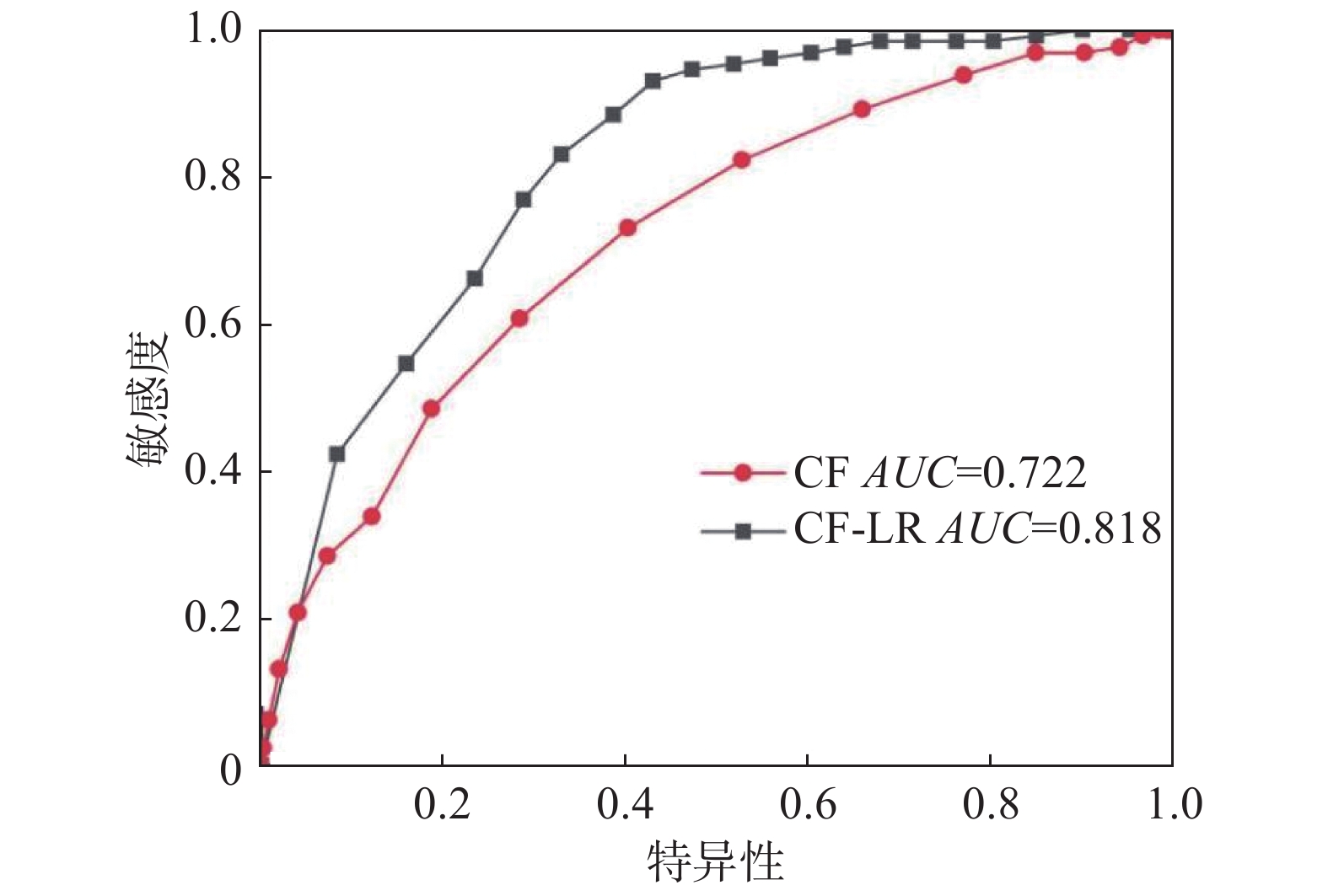
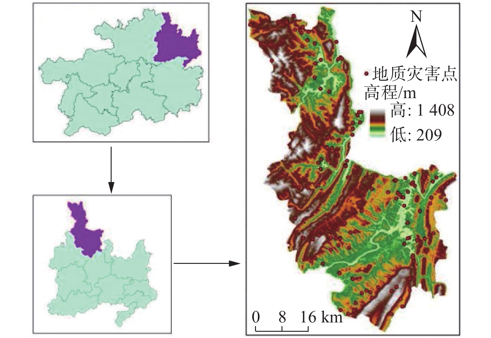
区域地质灾害易发性评价对地质灾害防治具有重要意义。本文以贵州省沿河县为研究区,考虑海拔、坡度、坡向、地形曲率、NDVI、工程地质岩组、断层、道路、水系9个因素,通过相关性分析后作为评价因子。分别利用CF模型和CF-LR模型评价沿河县地质灾害易发性。结果表明:CF模型比CF-LR模型地质灾害易发性等级的频率比值从低易发区到极高易发区明显增大,均有效评价了沿河县地质灾害易发性;CF-LR模型比CF模型AUC值提高了0.096,CF-LR模型具有更高的评价精度。
Abstract:The evaluation of regional geological disaster susceptibility is of great significance to the prevention and control of geological disasters. This paper takes Yanhe County in Guizhou Province as the research area, and considers 9 factors including altitude, slope, aspect, terrain curvature, NDVI, engineering geological rock formations, faults, roads, and water systems as evaluation factors. The CF model and the CF-LR model were used to evaluate the susceptibility of geological disasters in Yanhe County. The results show that the frequency ratio between the CF model and the CF-LR model of geological hazard susceptibility levels increases significantly from low-prone areas to extremely high-prone areas, which effectively evaluates the susceptibility of geological hazards in Yanhe County; the CF-LR model compares The AUC value of the CF model is increased by 0.096, and the CF-LR model has a higher evaluation accuracy.
-

-
表 1 评价指标因子相关性系数矩阵
Table 1. Correlation coefficient matrix of evaluation index factors
评价因子 海拔 坡度 坡向 地形曲率 NDVI 工程地质岩组 断层缓冲区 道路缓冲区 河流缓冲区 海拔 1 坡度 −0.009 1 坡向 0.009 0.059 1 地形曲率 0.138 0.045 −0.004 1 NDVI 0.154 0.094 −0.073 0.032 1 工程地质岩组 −0.004 0.004 −0.016 −0.010 −0.006 1 断层缓冲区 0.182 −0.002 0.002 0.004 0.024 0.104 1 道路缓冲区 0.113 0.081 0.004 0.009 0.043 0.007 0.060 1 河流缓冲区 0.324 −0.042 0.006 0.024 0.059 0.075 0.094 0.146 1  下载: 导出CSV
表 2 评价指标因子分级、频率比、确定性系数
Table 2. Evaluation index factor classification, frequency ratio and certainty coefficient
评价指
标因子分级 地质灾
害频数分级面积
/km2频率比 CF 评价指
标因子分级 地质灾
害频数分级面积
/km2频率比 CF 工程地
质岩组坚硬岩组 19 908.650 0.399 −0.374 地形
曲率<−0.2 54 842.320 1.225 0.194 较坚硬岩组 12 433.841 0.528 −0.485 −0.2~0.2 41 804.509 0.974 −0.028 较软岩组 24 354.624 1.293 0.239 ≥0.2 35 836.681 0.799 −0.210 软岩组 24 156.908 2.922 0.694 道路缓
冲区/m0~200 10 121.608 1.571 0.384 软硬相间岩组 51 629.487 1.548 0.373 200~400 7 110.030 1.215 0.187 海拔/m 209~400 19 125.528 2.892 0.690 400~600 8 102.096 1.497 0.350 400~600 35 630.016 1.061 0.061 600~800 8 96.148 1.590 0.391 600~800 46 781.436 1.125 0.117 800~1000 4 91.358 0.836 −0.206 800~1000 23 557.591 0.788 −0.221 ≥1000 93 1962.270 0.905 −0.099 1000~1200 5 329.869 0.290 −0.721 河流缓
冲区/m0~200 18 292.050 1.177 0.159 1200~1408 2 59.068 0.647 −0.366 200~400 20 270.762 1.411 0.307 坡度/(°) 0~8 8 360.777 0.424 −0.589 400~600 16 276.547 1.105 0.112 8~16 44 774.534 1.085 0.083 600~800 15 263.664 1.087 0.084 16~24 47 726.415 1.236 0.202 800~1000 13 249.447 0.996 −0.005 24~32 24 407.503 1.125 0.117 ≥1000 48 1131.039 0.811 −0.198 32~40 5 150.886 0.633 −0.380 断层缓
冲区/m0~300 15 263.922 1.086 0.083 ≥40 2 63.395 0.603 −0.410 300~600 13 246.968 1.006 0.006 坡向 平面 0 9.052 0.000 −1.000 600~900 13 230.345 1.078 0.077 北 17 249.994 1.299 0.243 900~1200 10 202.012 0.946 −0.057 东北 19 325.920 1.114 0.108 1200~1500 8 176.901 0.864 −0.143 东 32 390.819 1.564 0.381 ≥1500 71 1363.363 0.995 −0.005 东南 14 338.893 0.789 −0.220 NDVI −0.02~0.1 9 219.331 0.784 −0.225 南 9 253.127 0.679 −0.333 0.1~0.2 25 459.478 1.039 0.040 西南 21 287.807 1.394 0.298 0.2~0.3 61 1008.861 1.155 0.142 西 7 326.164 0.410 −0.603 0.3~0.4 34 757.656 0.857 −0.149 西北 11 301.734 0.696 −0.315 0.4~0.54 1 38.183 0.500 −0.513
下载: 导出CSV
表 3 频率比大于1的属性区间
Table 3. Attribute intervals with frequency ratio greater than 1
评价因子 海拔/m 坡度/(°) 坡向 地形曲率 NDVI 工程地质岩组 断层缓冲区/m 道路缓冲区/m 河流缓冲区/m 频率比大于
1类别209~400 8~16 北 < −0.2 0.1~0.2 较软质岩 0~300 0~200 0~200 400~600 16~24 东北 0.2~0.3 软质岩 300~600 200~400 200~400 600~800 24~32 东 软硬相间质岩 600~900 400~600 400~600 西南 600~800 600~800
下载: 导出CSV
表 4 逻辑回归系数和显著性
Table 4. Logistic regression coefficient and significance
评价因子 海拔 坡度 坡向 地形曲率 NDVI 工程地质岩组 断层缓冲区 道路缓冲区 河流缓冲区 常量 β 3.844 2.495 3.418 4.085 1.198 4.377 3.218 0.734 2.728 2.604 sig 0.000 0.003 0.000 0.019 0.023 0.000 0.027 0.036 0.130 0.000
下载: 导出CSV
表 5 地质灾害易发性评价频率比值
Table 5. Frequency ratio of geological hazard susceptibility evaluation
评价模型 易发性
等级分级面积
/km2面积
占比灾害点
频数灾害
占比频率比 CF 低易发区 361.265 0.145 3 0.023 0.159 中易发区 784.269 0.316 17 0.131 0.414 高易发区 895.197 0.360 47 0.362 1.003 极高易发区 442.779 0.178 63 0.485 2.718 CF-LR 低易发区 671.252 0.270 5 0.038 0.142 中易发区 467.758 0.188 8 0.062 0.327 高易发区 927.527 0.373 36 0.277 0.741 极高易发区 507.145 0.204 81 0.623 3.051
下载: 导出CSV
-
[1] 倪化勇, 王德伟, 陈绪钰, 等. 四川雅江县城地质灾害发育特征与稳定性评价[J]. 现代地质,2015,29(2):474 − 480. [NI Huayong, WANG Dewei, CHEN Xuyu, et al. Formation characteristics and stability assessment of geological hazards in Yajiang City, Sichuan Province[J]. Geoscience,2015,29(2):474 − 480. (in Chinese with English abstract) doi: 10.3969/j.issn.1000-8527.2015.02.036
[2] 牛全福. 基于GIS的地质灾害风险评估方法研究: 以“4·14”玉树地震为例[D]. 兰州: 兰州大学, 2011
NIU Quanfu. Study on the method of geological disaster risk assessment based on GIS: A case study in “4.14” Yushu earthquake[D]. Lanzhou: Lanzhou University, 2011. (in Chinese with English abstract)
[3] 王哲, 易发成. 基于层次分析法的绵阳市地质灾害易发性评价[J]. 水文地质工程地质,2007,34(3):93 − 98. [WANG Zhe, YI Facheng. Evaluation of geological hazard probability of occurrence based on analytical hierarchy process in Mianyang City[J]. Hydrogeology & Engineering Geology,2007,34(3):93 − 98. (in Chinese with English abstract) doi: 10.3969/j.issn.1000-3665.2007.03.024
[4] 王雷, 吴君平, 赵冰雪, 等. 基于GIS和信息量模型的安徽池州地质灾害易发性评价[J]. 中国地质灾害与防治学报,2020,31(3):96 − 103. [WANG Lei, WU Junping, ZHAO Bingxue, et al. Susceptibility assessment of geohazards in Chizhou City of Anhui Province based on GIS and informative model[J]. The Chinese Journal of Geological Hazard and Control,2020,31(3):96 − 103. (in Chinese with English abstract)
[5] 李益敏, 李驭豪, 赵志芳. 基于确定性系数模型的泸水市泥石流易发性评价[J]. 水土保持研究,2019,26(4):336 − 342. [LI Yimin, LI Yuhao, ZHAO Zhifang. Assessment on susceptibility of debris flow in Lushui based on the certain factor model[J]. Research of Soil and Water Conservation,2019,26(4):336 − 342. (in Chinese with English abstract)
[6] 胡燕, 李德营, 孟颂颂, 等. 基于证据权法的巴东县城滑坡灾害易发性评价[J]. 地质科技通报,2020,39(3):187 − 194. [HU Yan, LI Deying, MENG Songsong, et al. Landslide susceptibility evaluation in Badong County based on weights of evidence method[J]. Bulletin of Geological Science and Technology,2020,39(3):187 − 194. (in Chinese with English abstract)
[7] 任敬, 范宣梅, 赵程, 等. 贵州省都匀市滑坡易发性评价研究[J]. 水文地质工程地质,2018,45(5):165 − 172. [REN Jing, FAN Xuanmei, ZHAO Cheng, et al. Evaluation of the landslide vulnerability in Duyun of Guizhou Province[J]. Hydrogeology & Engineering Geology,2018,45(5):165 − 172. (in Chinese with English abstract)
[8] 牛瑞卿, 彭令, 叶润青, 等. 基于粗糙集的支持向量机滑坡易发性评价[J]. 吉林大学学报(地球科学版),2012,42(2):430 − 439. [NIU Ruiqing, PENG Ling, YE Runqing, et al. Landslide susceptibility assessment based on rough sets and support vector machine[J]. Journal of Jilin University (Earth Science Edition),2012,42(2):430 − 439. (in Chinese with English abstract)
[9] 杨永刚, 殷坤龙, 赵海燕, 等. 基于C5.0决策树-快速聚类模型的万州区库岸段乡镇滑坡易发性区划[J]. 地质科技情报,2019,38(6):189 − 197. [YANG Yonggang, YIN Kunlong, ZHAO Haiyan, et al. Landslide susceptibility evaluation for township units of bank section in Wanzhou district based on C5.0 decision tree and K-means cluster model[J]. Geological Science and Technology Information,2019,38(6):189 − 197. (in Chinese with English abstract)
[10] 刘睿, 施婌娴, 孙德亮, 等. 基于GIS与随机森林的巫山县滑坡易发性区划[J]. 重庆师范大学学报(自然科学版),2020,37(3):86 − 96. [LIU Rui, SHI Shuxian, SUN Deliang, et al. Based on GIS and random forest model for landslide susceptibility mapping in Wushan County[J]. Journal of Chongqing Normal University (Natural Science),2020,37(3):86 − 96. (in Chinese with English abstract)
[11] 周超, 殷坤龙, 曹颖, 等. 基于集成学习与径向基神经网络耦合模型的三峡库区滑坡易发性评价[J]. 地球科学,2020,45(6):1865 − 1876. [ZHOU Chao, YIN Kunlong, CAO Ying, et al. Landslide susceptibility assessment by applying the coupling method of radial basis neural network and adaboost: a case study from the Three Gorges reservoir area[J]. Earth Science,2020,45(6):1865 − 1876. (in Chinese with English abstract)
[12] 杨光, 徐佩华, 曹琛, 等. 基于确定性系数组合模型的区域滑坡敏感性评价[J]. 工程地质学报,2019,27(5):1153 − 1163. [YANG Guang, XU Peihua, CAO Chen, et al. Assessment of regional landslide susceptibility based on combined model of certainty factor method[J]. Journal of Engineering Geology,2019,27(5):1153 − 1163. (in Chinese with English abstract)
[13] 李文彦, 王喜乐. 频率比与信息量模型在黄土沟壑区滑坡易发性评价中的应用与比较[J]. 自然灾害学报,2020,29(4):213 − 220. [LI Wenyan, WANG Xile. Application and comparison of frequency ratio and information value model for evaluating landslide susceptibility of loess gully region[J]. Journal of Natural Disasters,2020,29(4):213 − 220. (in Chinese with English abstract)
[14] 黄发明, 叶舟, 姚池, 等. 滑坡易发性预测不确定性: 环境因子不同属性区间划分和不同数据驱动模型的影响[J]. 地球科学,2020,45(12):4535 − 4549. [HUANG Faming, YE Zhou, YAO Chi, et al. Uncertainties of landslide susceptibility prediction: Different attribute interval divisions of environmental factors and different data-based models[J]. Earth Science,2020,45(12):4535 − 4549. (in Chinese with English abstract)
[15] MERSHA T, METEN M. GIS-based landslide susceptibility mapping and assessment using bivariate statistical methods in Simada area, northwestern Ethiopia[J]. Geoenvironmental Disasters,2020,7:20. doi: 10.1186/s40677-020-00155-x
[16] 马思远, 许冲, 田颖颖, 等. 基于逻辑回归模型的九寨沟地震滑坡危险性评估[J]. 地震地质,2019,41(1):162 − 177. [MA Siyuan, XU Chong, TIAN Yingying, et al. Application of logistic regression model for hazard assessment of earthquake-triggered landslides: A case study of 2017 Jiuzhaigou(China) Ms7.0 event[J]. Seismology and Geology,2019,41(1):162 − 177. (in Chinese with English abstract) doi: 10.3969/j.issn.0253-4967.2019.01.011
[17] 王进, 郭靖, 王卫东, 等. 权重线性组合与逻辑回归模型在滑坡易发性区划中的应用与比较[J]. 中南大学学报(自然科学版),2012,43(5):1932 − 1939. [WANG Jin, GUO Jing, WANG Weidong, et al. Application and comparison of weighted linear combination model and logistic regression model in landslide susceptibility mapping[J]. Journal of Central South University (Science and Technology),2012,43(5):1932 − 1939. (in Chinese with English abstract)
[18] 邓念东, 石辉, 文强, 等. 信息量支持下的随机森林模型的崩塌易发性评价[J]. 科学技术与工程,2021,21(6):2210 − 2217. [DENG Niandong, SHI Hui, WEN Qiang, et al. Collapse susceptibility evaluation of random forest model supported by information value model[J]. Science Technology and Engineering,2021,21(6):2210 − 2217. (in Chinese with English abstract) doi: 10.3969/j.issn.1671-1815.2021.06.012
[19] 蒋德明, 李益敏, 鲍华姝. 泸水县滑坡孕灾环境因素敏感性研究[J]. 自然灾害学报,2016,25(4):109 − 119. [JIANG Deming, LI Yimin, BAO Huashu. Study on sensitivity in disaster-pregnant environmental factors of landslide in Lushui County[J]. Journal of Natural Disasters,2016,25(4):109 − 119. (in Chinese with English abstract)
[20] 吴森, 李虎杰, 陈国辉, 等. 基于贡献率权重法的区域滑坡影响因子敏感性分析[J]. 中国地质灾害与防治学报,2016,27(1):26 − 31. [WU Sen, LI Hujie, CHEN Guohui, et al. Regional landslides influence factors sensitivity analysis based on contributing weight method[J]. The Chinese Journal of Geological Hazard and Control,2016,27(1):26 − 31. (in Chinese with English abstract)
[21] 王佳佳, 殷坤龙, 肖莉丽. 基于GIS和信息量的滑坡灾害易发性评价: 以三峡库区万州区为例[J]. 岩石力学与工程学报,2014,33(4):797 − 808. [WANG Jiajia, YIN Kunlong, XIAO Lili. Landslide susceptibility assessment based on GIS and weighted information value: A case study of Wanzhou district, Three Gorges Reservoir[J]. Chinese Journal of Rock Mechanics and Engineering,2014,33(4):797 − 808. (in Chinese with English abstract)
[22] 张玘恺, 凌斯祥, 李晓宁, 等. 九寨沟县滑坡灾害易发性快速评估模型对比研究[J]. 岩石力学与工程学报,2020,39(8):1595 − 1610. [ZHANG Qikai, LING Sixiang, LI Xiaoning, et al. Comparison of landslide susceptibility mapping rapid assessment models in Jiuzhaigou County, Sichuan Province, China[J]. Chinese Journal of Rock Mechanics and Engineering,2020,39(8):1595 − 1610. (in Chinese with English abstract)
[23] 孙小凡, 张鹏, 党超. 基于GIS的城市滑坡灾害易发性评价: 以湖北省宜昌市城区为例[J]. 水土保持通报,2018,38(6):304 − 309. [SUN Xiaofan, ZHANG Peng, DANG Chao. Landslide proneness evaluation based on GIS platform in urban area of Yichang City, Hubei Province[J]. Bulletin of Soil and Water Conservation,2018,38(6):304 − 309. (in Chinese with English abstract)
[24] 倪树斌, 马超, 杨海龙, 等. 北京山区崩塌、滑坡、泥石流灾害空间分布及其敏感性分析[J]. 北京林业大学学报,2018,40(6):81 − 91. [NI Shubin, MA Chao, YANG Hailong, et al. Spatial distribution and susceptibility analysis of avalanche, landslide and debris flow in Beijing Mountain region[J]. Journal of Beijing Forestry University,2018,40(6):81 − 91. (in Chinese with English abstract)
[25] 杜晓晨, 陈莉, 陈廷芳. 基于GIS的凉山州德昌县滑坡危险性评价[J]. 长江流域资源与环境,2020,29(5):1206 − 1215. [DU Xiaochen, CHEN Li, CHEN Tingfang. Hazard assessment of landslide in Dechang County of Liangshan state based on GIS[J]. Resources and Environment in the Yangtze Basin,2020,29(5):1206 − 1215. (in Chinese with English abstract)
[26] 梁丽萍, 刘延国, 唐自豪, 等. 基于加权信息量的地质灾害易发性评价—以四川省泸定县为例[J]. 水土保持通报,2019,39(6):176 − 182. [LIANG Liping, LIU Yanguo, TANG Zihao, et al. Geologic hazards susceptibility assessment based on weighted information value: A case study in Luding County, Sichuan Province[J]. Bulletin of Soil and Water Conservation,2019,39(6):176 − 182. (in Chinese with English abstract)
[27] 杜谦, 范文, 李凯, 等. 二元Logistic回归和信息量模型在地质灾害分区中的应用[J]. 灾害学,2017,32(2):220 − 226. [DU Qian, FAN Wen, LI Kai, et al. Geohazard susceptibility assessment by using binary logical regression and information value model[J]. Journal of Catastrophology,2017,32(2):220 − 226. (in Chinese with English abstract) doi: 10.3969/j.issn.1000-811X.2017.02.039
[28] 栗泽桐, 王涛, 周杨, 等. 基于信息量、逻辑回归及其耦合模型的滑坡易发性评估研究—以青海沙塘川流域为例[J]. 现代地质,2019,33(1):235 − 245. [LI Zetong, WANG Tao, ZHOU Yang, et al. Landslide susceptibility assessment based on information value model, logistic regression model and their integrated model: A case in Shatang River Basin, Qinghai Province[J]. Geoscience,2019,33(1):235 − 245. (in Chinese with English abstract)
-


图(4)
表(5)
计量
- 文章访问数: 1616
- PDF下载数: 22
- 施引文献: 0