Primary establishment of an early warning model of debris flow hazards in Nyingchi City of Xizang autonomous region based on raster runoff simulation
-
摘要:
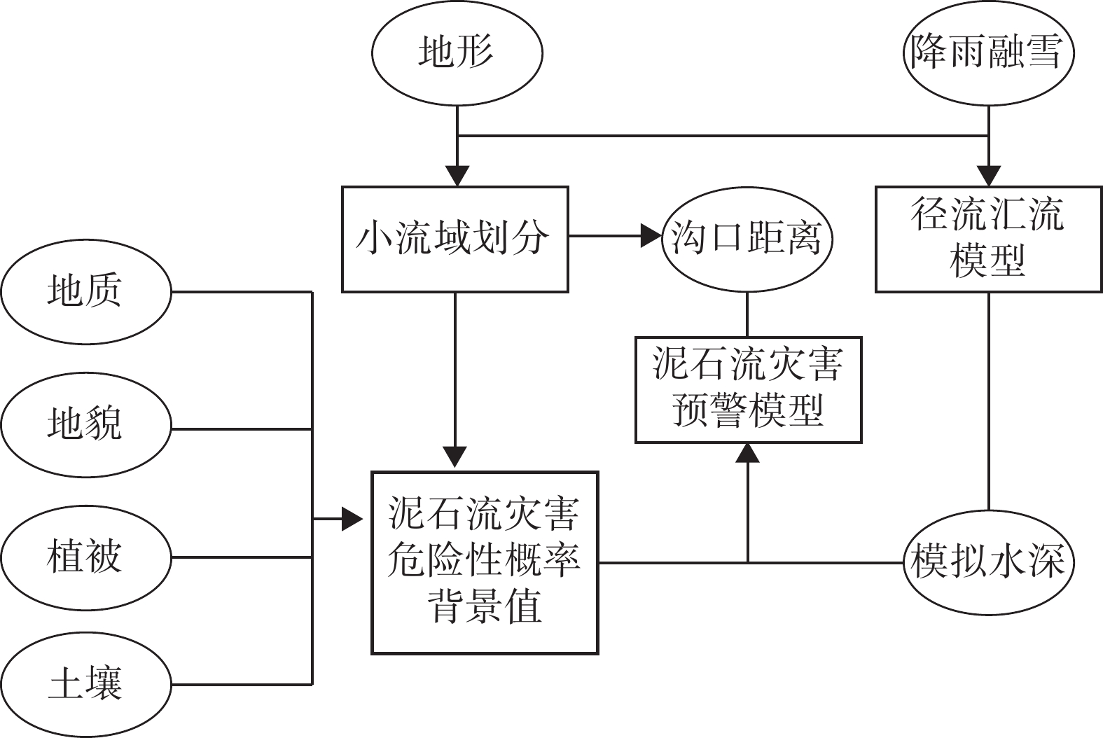
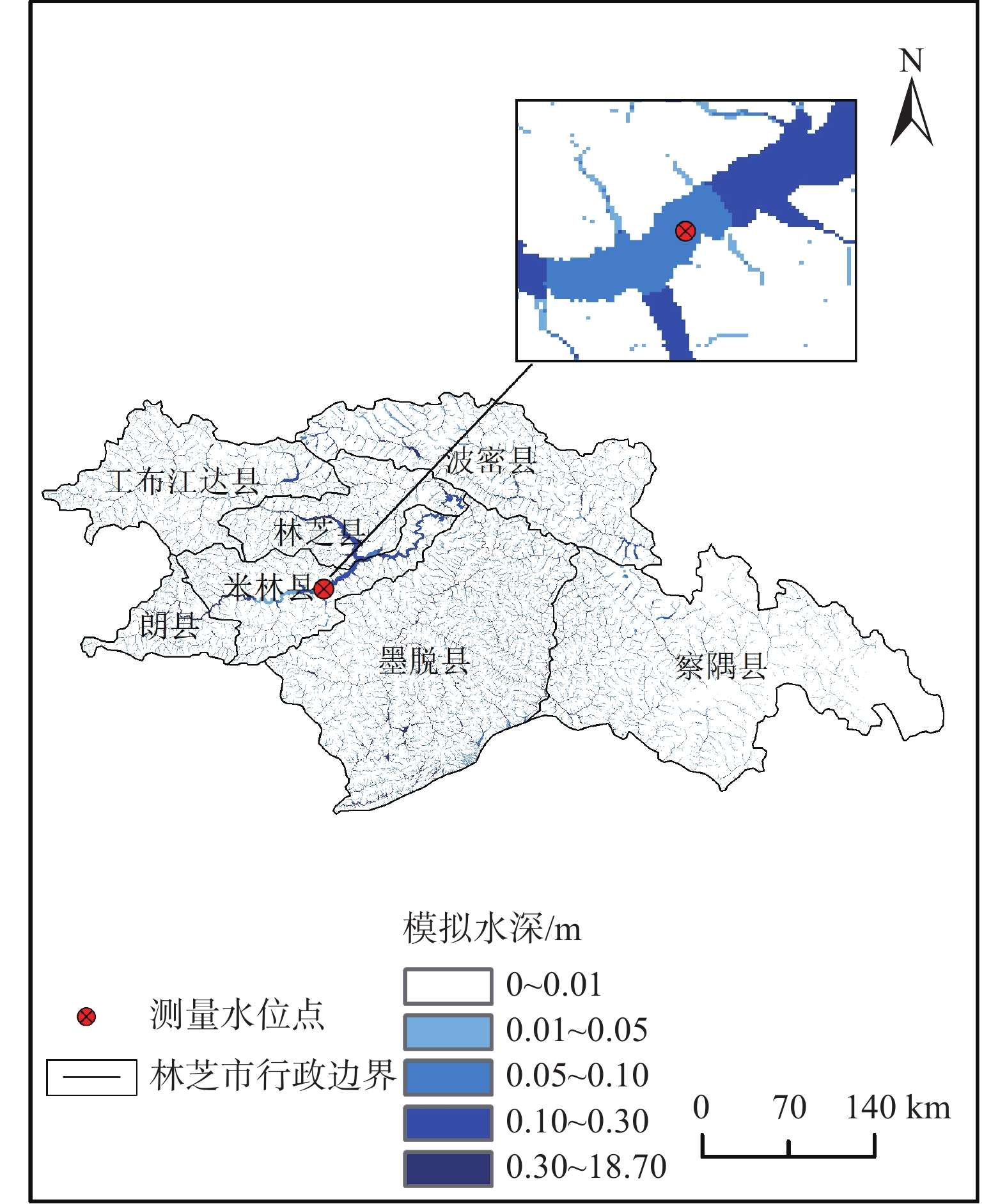
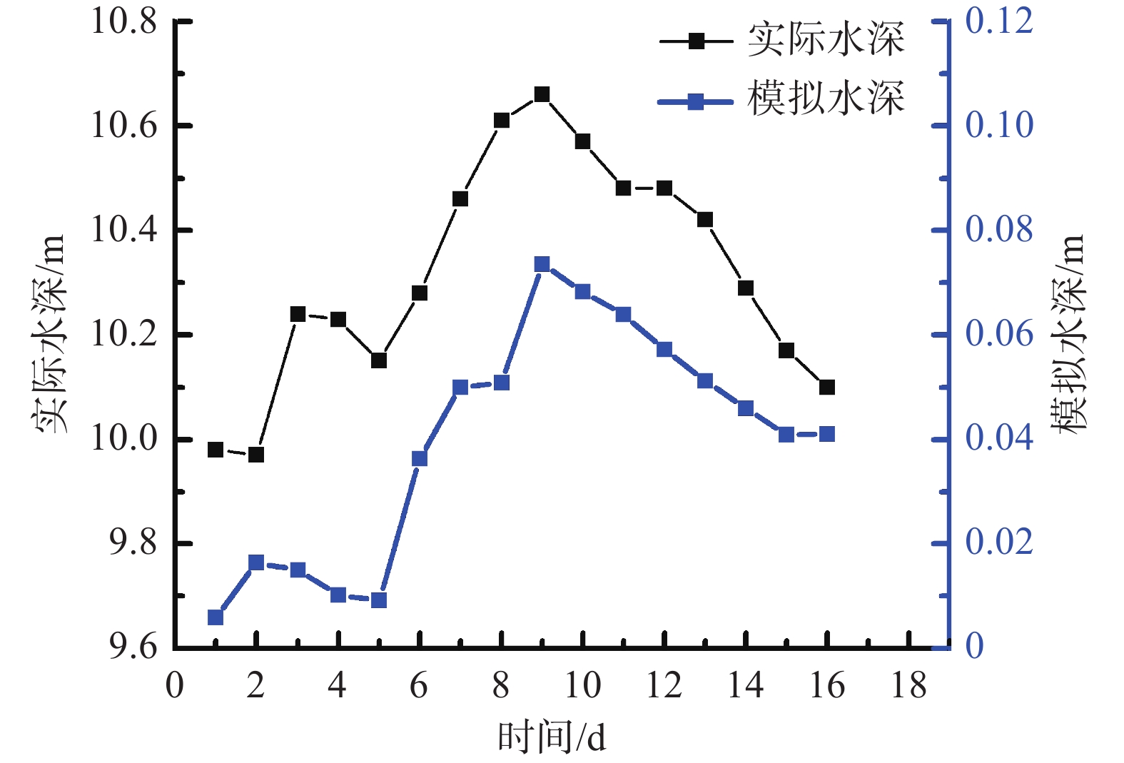
西藏林芝市泥石流灾害频发,亟需建立泥石流灾害预警模型,预测林芝市泥石流灾害可能发生的区域,减少泥石流灾害导致的损失。文章提出了一种基于栅格径流汇流的林芝市泥石流灾害预警模型,从栅格像元尺度上模拟流域各位置上的水深,以提高泥石流预警的空间针对性。该模型将泥石流致灾因子分为背景因子和激发因子。通过林芝市裸岩率、河床纵比降等因子的逻辑回归,获取林芝市泥石流灾害概率,作为泥石流预警模型的背景因子;引入栅格径流汇流模型,以站点降水和雪水当量为模型的水量输入,模拟预警时段内的流域各位置上的模型水深,作为泥石流预警模型的激发因子。利用二元逻辑回归的方法计算背景因子和激发因子的权重,建立泥石流预警模型。利用2011—2020年18次历史灾害对模型进行验证,落入预警区内的灾害点占比64.4%,预警精度较高,对于林芝市泥石流灾害预警具有一定的指导意义。
Abstract:Debris flow disasters occur frequently in Nyingchi City, Xizang. There is an urgent need to establish an early warning model to predict the possible areas of debris flow disasters in Nyingchi City and reduce the losses caused by those disasters. This paper presented an early warning model based on raster runoff simulation in Nyingchi City, which can simulate the water depth at each location in the watershed and improve the spatial pertinence of debris flow early warning. In this model, the disaster factors of debris flow are divided into background factor and excitation factor. The probability of debris flow disaster in Nyingchi City is obtained by logistic regression of many factors such as bare rock rate, vertical slope of riverbed and so on, which is used as the background factor. The raster runoff simulation model is introduced to simulate the predicted water depth at each position of the basin during the early warning period by importing the precipitation and snow water equivalent data. Using binary logistic regression method to calculate the weight of background factor and excitation factor, the final model is obtained. 18 historical disasters from 2011 to 2020 were used to verify the model. The disaster points falling into the early warning area accounted for 64.4%, which has certain guiding significance for the early warning of debris flow disaster in Nyingchi City.
-
Key words:
- Nyingchi City /
- debris flow disaster /
- runoff simulation
-

-
表 1 逻辑回归分析结果
Table 1. Results of logistic regression analysis
指标因子 B S.E Wals df Sig. exp(B) 裸岩信息 0.925 0.456 4.119 1 0.042 2.523 流域面积 0.880 0.394 5.000 1 0.025 2.412 沟床纵比降 1.042 0.186 31.348 1 0 2.834 河流 1.000 0.122 66.763 1 0 2.717 道路 0.879 0.105 69.489 1 0 2.409 断层密度 0.995 0.442 5.059 1 0.024 2.704 土地利用 0.541 0.245 4.888 1 0.027 1.718 土壤类型 0.603 0.112 18.239 1 0 1.828 隐患点密度 0.896 0.297 63.593 1 0 2.449 沟谷密度 1.295 0.211 19.043 1 0 3.650 年降水量 1.064 0.281 25.459 1 0 2.897 常量 −1.485 0.281 27.852 1 0 0.226 注:B为逻辑回归系数;S.E.为标准误差;Wals为卡方值统计量;df为自由度;Sig.为显著性。 表 2 泥石流灾害的概率占比
Table 2. Probability proportion of debris flow disaster
级别 取值区间 灾害点数量 百分比/% 一级 [0, 0.2) 8 6.25 二级 [0.2, 0.4) 5 3.90 三级 [0.4, 0.6) 2 1.56 四级 [0.6, 0.8) 9 7.03 五级 [0.8, 1) 104 81.25 表 3 径流水深分级
Table 3. Classification of runoff depth
级别 水深区间/m 1 (0, 0.01] 2 (0.01, 0.05] 3 (0.05, 0.1] 4 (0.1, 0.3] 5 >0.3 表 4 逻辑回归方程表
Table 4. Logistic regression equation table
B S.E. Wald df Sig. exp(B) P 0.790 0.257 9.486 1 0.002 2.204 D 0.834 0.297 7.910 1 0.005 2.303 常量 −5.330 1.432 13.857 1 0.000 0.005 注:B为逻辑回归系数;S.E.为标准误差;Wald为卡方值;df为自由度;Sig.为显著性。 表 5 泥石流灾害预警验证结果
Table 5. Validation results of debris flow disaster early warning
序号 灾害日期 灾害点数/个 预警区内灾害点数/个 1 2011年7月14日 2 1 2 2013年7月6日 1 1 3 2014年4月16日 1 0 4 2014年7月18日 1 0 5 2015年8月6日 5 1 6 2015年8月19日 12 7 7 2015年8月20日 2 2 8 2015年8月21日 3 3 9 2016年4月25日 1 1 10 2016年7月26日 3 3 11 2016年7月27日 2 1 12 2017年8月3日 1 0 13 2017年7月21日 1 1 14 2018年9月9日 1 1 15 2019年7月7日 2 1 16 2020年7月10日 2 2 17 2020年7月11日 3 2 18 2020年8月15日 2 2 合计 45 29 -
[1] 屈永平, 唐川, 刘洋, 等. 西藏林芝地区冰川降雨型泥石流调查分析[J]. 岩石力学与工程学报, 2015, 34(增刊2): 4013 − 4022
QU Yongping, TANG Chuan, LIU Yang, et al. Investigation and analysis of glacier debris flow in Nyingchi area, Xizang[J]. Chinese Journal of Rock Mechanics and Engineering, 2015, 34(Sup 2): 4013 − 4022. (in Chinese with English abstract)
[2] 陈宫燕,普布桑姆,次仁旺姆,等. 基于Logistic回归方法的林芝市山洪地质灾害预警研究[J]. 中国农学通报,2019,35(23):124 − 130. [CHEN Gongyan,PU Busangmu,CI Renwangmu,et al. Early warning of mountain flood geological disasters in Nyingchi based on logistic regression method[J]. Chinese Agricultural Science Bulletin,2019,35(23):124 − 130. (in Chinese with English abstract) doi: 10.11924/j.issn.1000-6850.casb18040021
[3] 陈宫燕,普布桑姆,次仁,等. 西藏林芝降水引发的山洪地质灾害分布特征[J]. 中国地质灾害与防治学报,2018,29(2):100 − 103. [CHEN Gongyan,PU Busangmu,CIREN,et al. Distribution characteristics of mountain flood and geological disaster caused by precipitation of Nyingchi in Xizang[J]. The Chinese Journal of Geological Hazard and Control,2018,29(2):100 − 103. (in Chinese with English abstract)
[4] SALINAS-JASSO J A,VELASCO-TAPIA F,DE LEÓN I N,et al. Estimation of rainfall thresholds for shallow landslides in the Sierra Madre Oriental,northeastern Mexico[J]. Journal of Mountain Science,2020,17(7):1565 − 1580. doi: 10.1007/s11629-020-6050-2
[5] YAN Y,ZHANG Y,HU W,et al. A multiobjective evolutionary optimization method based critical rainfall thresholds for debris flows initiation[J]. Journal of Mountain Science,2020,17(8):1860 − 1873. doi: 10.1007/s11629-019-5812-1
[6] 马煜,李彩侠. 地形因子对四川龙溪河流域泥石流发生的影响[J]. 中国地质灾害与防治学报,2018,29(2):16 − 21. [MA Yu,LI Caixia. Effect of topographic factor on the formation of debris flows in Longxi River Area,Sichuan Province[J]. The Chinese Journal of Geological Hazard and Control,2018,29(2):16 − 21. (in Chinese with English abstract)
[7] 熊江,唐川,陈明. 泥石流早期识别与监测预警研究进展探讨[J]. 自然灾害学报,2021,30(1):165 − 173. [XIONG Jiang,TANG Chuan,CHEN Ming. Discussion on the research progress of early identification,monitoring and early warning of debris flow[J]. Journal of Natural Disasters,2021,30(1):165 − 173. (in Chinese with English abstract)
[8] 王英杰. 岷江上游泥石流预警报模型构建及其应用[D]. 绵阳: 西南科技大学, 2020
WANG Yingjie. Construction and application of debris flow early-warning and forecast model in the upper Min River[D]. Mianyang: Southwest University of Science and Technology, 2020. (in Chinese with English abstract)
[9] PONZIANI M,POGLIOTTI P,STEVENIN H,et al. Debris-flow Indicator for an early warning system in the Aosta valley region[J]. Natural Hazards,2020,104(2):1819 − 1839. doi: 10.1007/s11069-020-04249-5
[10] 黄健,胡卸文,金涛,等. 四川西昌“3·30”火烧区响水沟火后泥石流成灾机理[J]. 中国地质灾害与防治学报,2022,33(3):15 − 22. [HUANG Jian,HU Xiewen,JIN Tao,et al. Mechanism of the post-fire debris flow of the Xiangshui gully in “3·30” fire area of Xichang, Sichuan Province[J]. The Chinese Journal of Geological Hazard and Control,2022,33(3):15 − 22. (in Chinese with English abstract)
[11] 包红军,王凯,张少杰,等. 耦合分布式水文模型的泥石流物理模型预报试验[J]. 暴雨灾害,2018,37(4):303 − 310. [BAO Hongjun,WANG Kai,ZHANG Shaojie,et al. Debris flow forecasting test based on a physical model coupling with a distributed hydrological model[J]. Torrential Rain and Disasters,2018,37(4):303 − 310. (in Chinese with English abstract)
[12] 王治华,郭兆成,杜明亮,等. 基于数字滑坡技术的暴雨滑坡、泥石流预警、监测模型研究[J]. 地学前缘,2011,18(5):303 − 309. [WANG Zhihua,GUO Zhaocheng,DU Mingliang,et al. Model study of monitoring and early warning of rainstorm induced landslide and debris flow based on digital landslide technology[J]. Earth Science Frontiers,2011,18(5):303 − 309. (in Chinese with English abstract)
[13] 王海芝. 北京地区暴雨泥石流预警阈值研究[J]. 第四纪研究,2020,40(5):1371 − 1380. [WANG Haizhi. Early warning thresholds of the rainfall-induced debris flows in Beijing[J]. Quaternary Sciences,2020,40(5):1371 − 1380. (in Chinese with English abstract) doi: 10.11928/j.issn.1001-7410.2020.05.24
[14] BUGAETS A N,GARTSMAN B I,TERESHKINA A A,et al. Using the SWAT model for studying the hydrological regime of a small river basin (the komarovka river,primorsky Krai)[J]. Russian Meteorology and Hydrology,2018,43(5):323 − 331. doi: 10.3103/S1068373918050060
[15] THOMPSON J R,SØRENSON H R,GAVIN H,et al. Application of the coupled MIKE SHE/MIKE 11 modelling system to a lowland wet grassland in southeast England[J]. Journal of Hydrology,2004,293(1/2/3/4):151 − 179.
[16] 王济,蔡雄飞,雷丽,等. 不同裸岩率下我国西南喀斯特山区土壤侵蚀的室内模拟[J]. 中国岩溶,2010,29(1):1 − 5. [WANG Ji,CAI Xiongfei,LEI Li,et al. Laboratory simulation on soil erosion under different bedrock outcrop rate in Southwest Karst area, China[J]. Carsologica Sinica,2010,29(1):1 − 5. (in Chinese with English abstract)
[17] LIU W, HE S. Comprehensive modelling of runoff-generated debris flow from formation to propagation in a catchment. Landslides, 2020, 17(4): 1529 − 1544.
[18] 张书豪,吴光,张乔,等. 基于子流域特征的泥石流易发性评价[J]. 水文地质工程地质,2018,45(2):142 − 149. [ZHANG Shuhao,WU Guang,ZHANG Qiao,et al. Debris-flow susceptibility assessment using the characteristic factors of a catchment[J]. Hydrogeology & Engineering Geology,2018,45(2):142 − 149. (in Chinese with English abstract)
[19] 张以晨,秦胜伍,翟健健,等. 基于信息量的长白山地区泥石流易发性评价[J]. 水文地质工程地质,2018,45(2):150 − 158. [ZHANG Yichen,QIN Shengwu,ZHAI Jianjian,et al. Susceptibility assessment of debris flow based on GIS and weight information for the Changbai Mountain area[J]. Hydrogeology & Engineering Geology,2018,45(2):150 − 158. (in Chinese with English abstract)
[20] 张盼盼,胡远满,肖笃宁,等. 一种基于多光谱遥感影像的喀斯特地区裸岩率的计算方法初探[J]. 遥感技术与应用,2010,25(4):510 − 514. [ZHANG Panpan,HU Yuanman,XIAO Duning,et al. A method of the percentage of bare rock calculation in Karst areas based on multi-spectrum remote sensing image[J]. Remote Sensing Technology and Application,2010,25(4):510 − 514. (in Chinese with English abstract) doi: 10.11873/j.issn.1004-0323.2010.4.510
[21] 陈冠,孟兴民,郭鹏,等. 白龙江流域基于GIS与信息量模型的滑坡危险性等级区划[J]. 兰州大学学报(自然科学版),2011,47(6):1 − 6. [CHEN Guan,MENG Xingmin,GUO Peng,et al. Landslide susceptibility mapping based on GIS and information value model in Bailong River Basin[J]. Journal of Lanzhou University (Natural Sciences),2011,47(6):1 − 6. (in Chinese with English abstract)
[22] 王卫东,钟晟. 基于GIS的Logistic回归模型在地质灾害危险性区划中的应用[J]. 工程勘察,2009,37(11):5 − 10. [WANG Weidong,ZHONG Sheng. The application of GIS-based logistic regression for geological hazards zonation[J]. Geotechnical Investigation & Surveying,2009,37(11):5 − 10. (in Chinese with English abstract)
[23] HOCK R. Glacier melt:A review of processes and their modelling[J]. Progress in Physical Geography:Earth and Environment,2005,29(3):362 − 391. doi: 10.1191/0309133305pp453ra
[24] 张勇,刘时银. 度日模型在冰川与积雪研究中的应用进展[J]. 冰川冻土,2006,28(1):101 − 107. [ZHANG Yong,LIU Shiyin. Progress of the application of degree-day model to study glaciers and snow cover[J]. Journal of Glaciology and Geocryology,2006,28(1):101 − 107. (in Chinese with English abstract) doi: 10.3969/j.issn.1000-0240.2006.01.014
[25] 闫玉娜,车涛,李弘毅,等. 使用积雪遥感面积数据改善山区春季融雪径流模拟精度[J]. 冰川冻土,2016,38(1):211 − 221. [YAN Yuna,CHE Tao,LI Hongyi,et al. Using snow remote sensing data to improve the simulation accuracy of spring snowmelt runoff:Take Babao River Basin as an example[J]. Journal of Glaciology and Geocryology,2016,38(1):211 − 221. (in Chinese with English abstract)
[26] OMANI N,SRINIVASAN R,SMITH P K,et al. Glacier mass balance simulation using SWAT distributed snow algorithm[J]. Hydrological Sciences Journal,2017,62(4):546 − 560. doi: 10.1080/02626667.2016.1162907
-


 下载:
下载:
