

Deformation analysis in the bank slopes in the reservoir area of Baihetan Hydropower Station based on SBAS-InSAR technology
-
摘要:
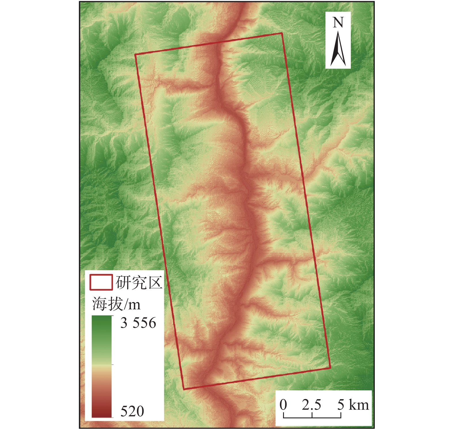
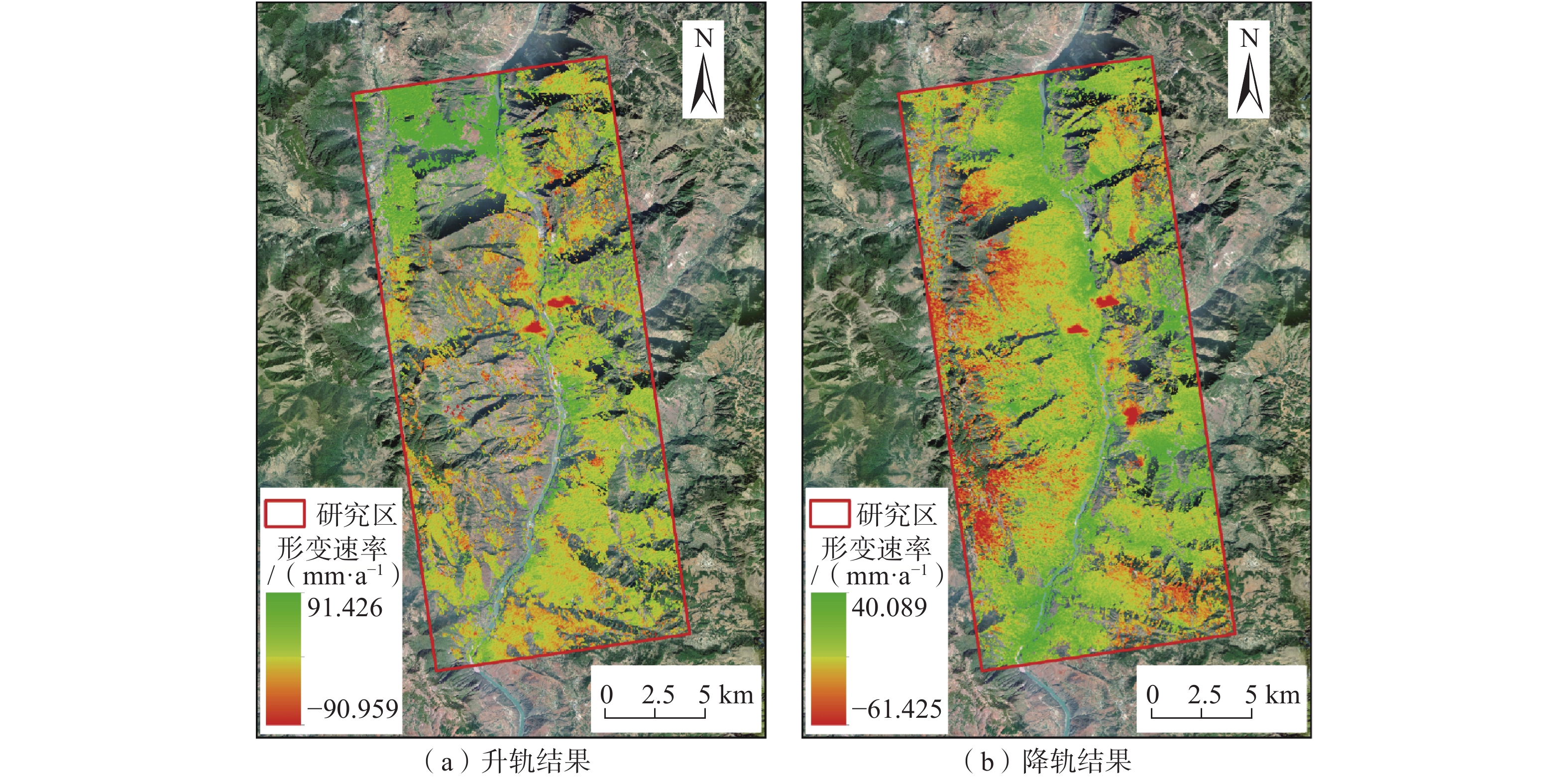
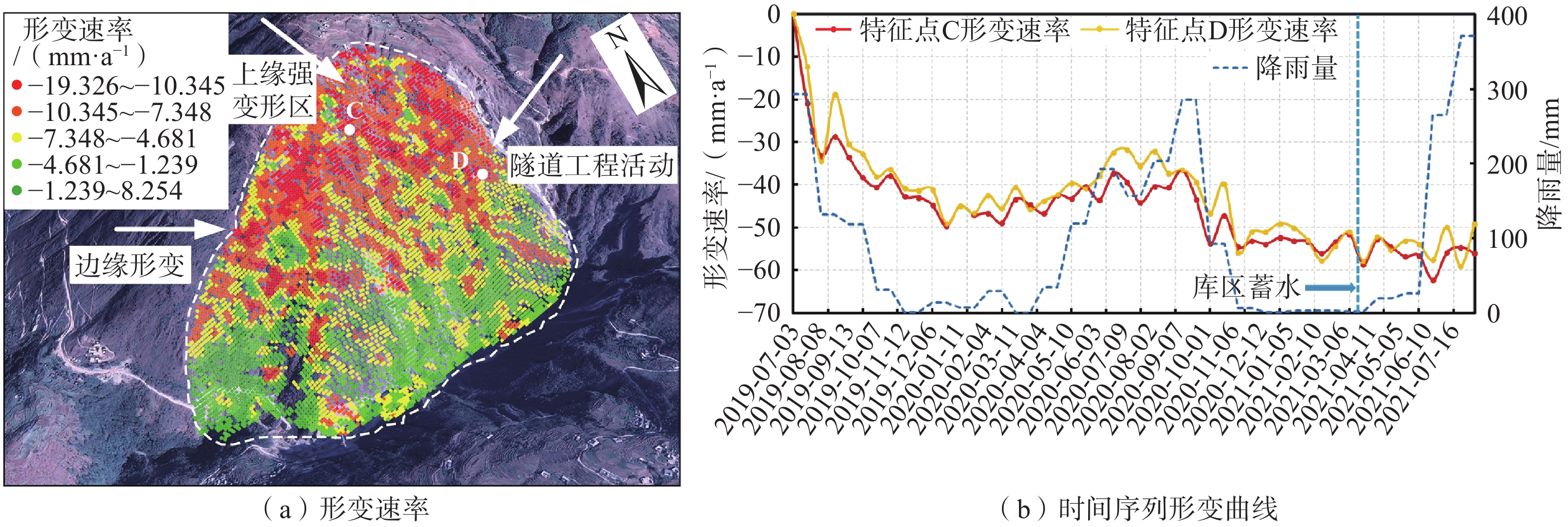
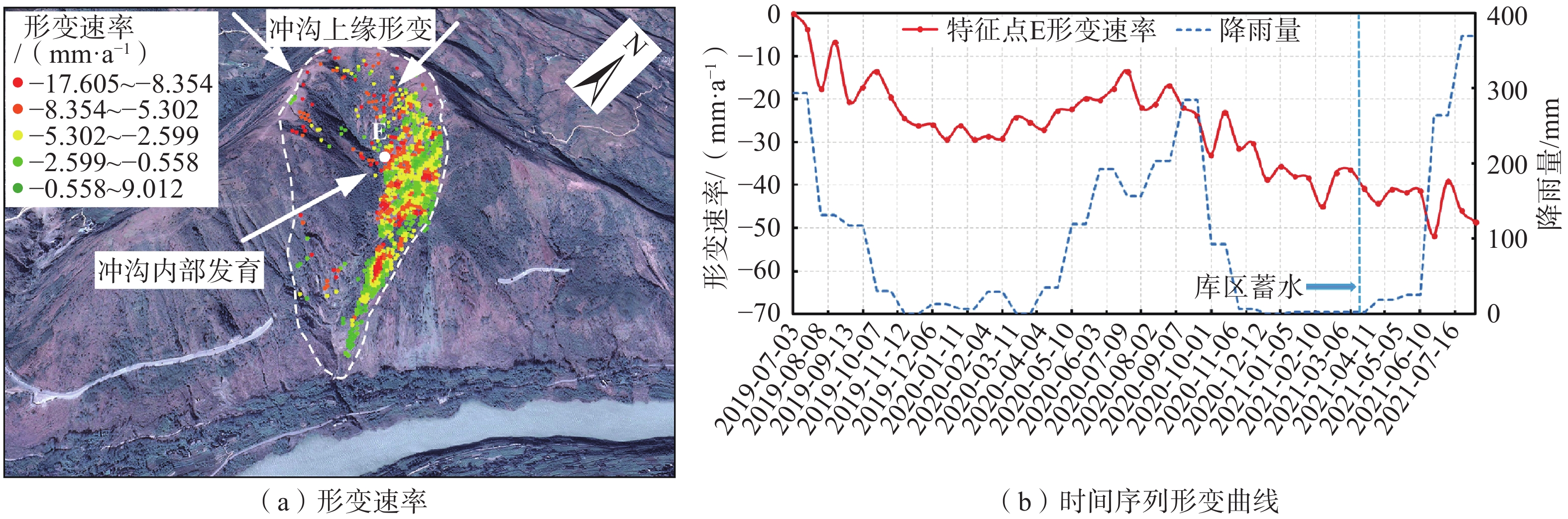
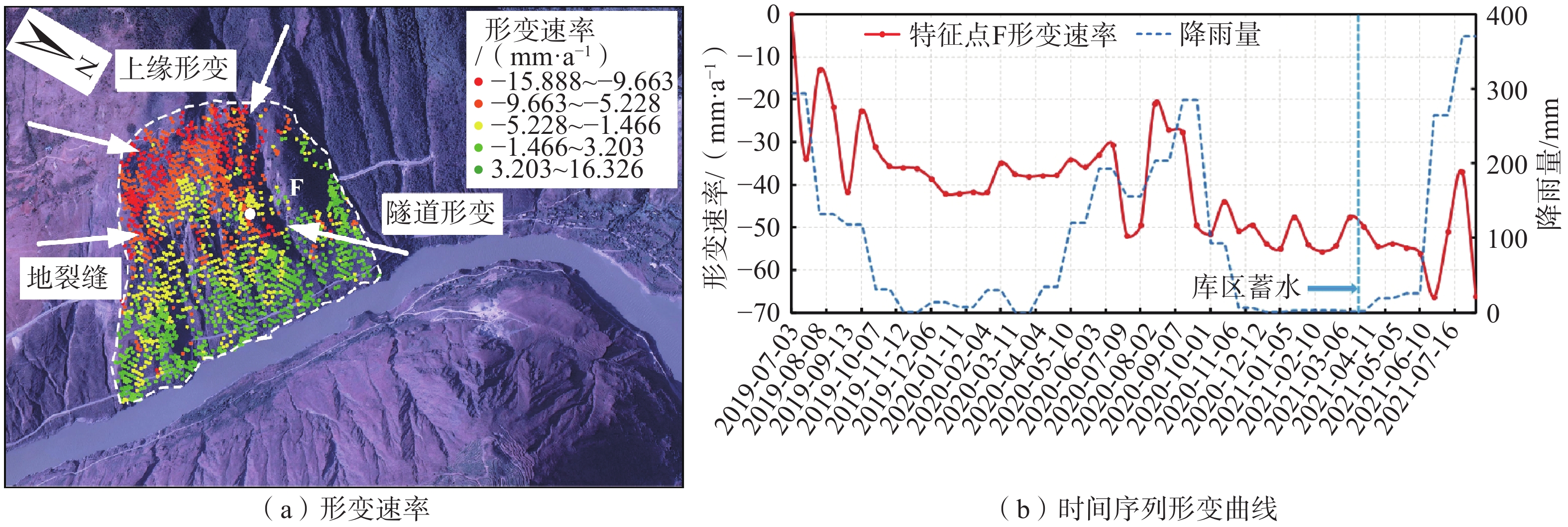
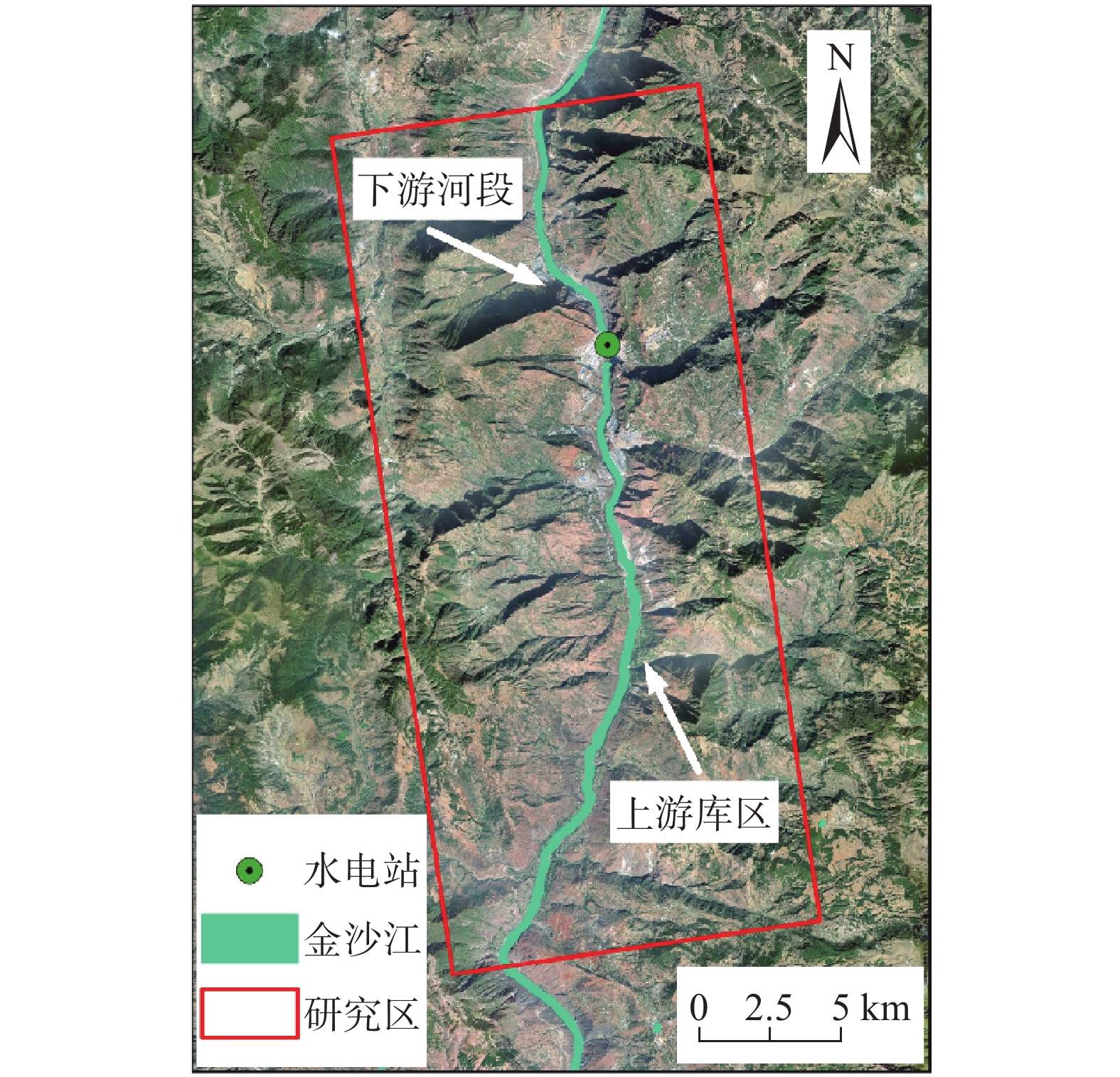
库岸潜在滑坡变形分析是保障国家水利水电设施安全运行的重要环节,针对仅利用单一轨道SAR数据对库岸潜在滑坡变形监测不准确的问题,采用SBAS-InSAR技术,联合升降轨Sentinel-1 SAR数据构建研究区2019年7月至2021年7月的雷达视线方向形变时间序列,并结合无人机野外调查,分析白鹤滩水电站库岸典型潜在滑坡的变形特征。结果表明:(1)受蓄水因素影响,白鹤滩水电站库岸潜在滑坡形变平均增速达10 mm/a以上,库岸稳定性受到破坏;(2)蓄水量变化是当前库岸滑坡发育的关键性诱因,在蓄水和降雨等因素共同作用下,白鹤滩水电站库岸潜在滑坡存在失稳风险;(3)升降轨SAR数据结合的方式能有效克服单一轨道导致的几何畸变等问题,使水电站库岸潜在滑坡变形监测更加准确、全面。研究结果有助于了解库区蓄水对库岸潜在滑坡变形趋势的影响,可为区域尺度防灾应急管理提供科学支持。
-
关键词:
- SBAS-InSAR技术 /
- 滑坡灾害 /
- 地表形变 /
- 变形分析 /
- 白鹤滩水电站
Abstract:The analysis of potential landslide deformation on the reservoir bank is an important link to ensure the safe operation of national water conservancy and hydropower facilities. In response to the problem of inaccurate monitoring of potential landslide deformation on the reservoir bank using single-track SAR data only, this paper uses SBAS-InSAR technology to construct the radar line-of-sight directional deformation of the study area from July 2019 to July 2021 by combining elevated-track Sentinel-1 SAR data time series, and unmanned aircraft field surveys were combined to analyse the deformation characteristics of typical potential landslides on the reservoir bank of Baihetan hydropower station. The results show that: (1) under the influence of water storage factors, the average growth rate of potential landslide deformation on the reservoir bank of Baihetan hydropower station reaches more than 10 mm/a. Reservoir bank stability is undermined; (2) water storage changes are the key causal factor in the development of reservoir bank potential landslides at present. The potential landslides on the reservoir bank of Baihetan Hydropower Station are at risk of instability with the joint effect factors such as water storage and rainfall; (3) the method which combined lift-track SAR data can effectively overcome the problems such as geometric distortion caused by a single track, and make the monitoring of potential landslide deformation on the reservoir bank of hydropower station more accurate and comprehensive. The research result can help to understand the impact of reservoir storage on the deformation trend of reservoir bank potential landslides, and can provide scientific support for regional-scale disaster prevention and emergency management.
-

-
表 1 Sentinel-1A数据参数
Table 1. Sentinel-1A data parameters
轨道方向 成像模式 极化方式 波长 波段 入射角/(°) 升轨 IW VV 5.63 C 39.44 降轨 IW VV 5.63 C 39.28  下载: 导出CSV
表 2 升轨数据库岸形变区域解译结果列表
Table 2. List of interpretation results of shore deformation region in orbit lifting database
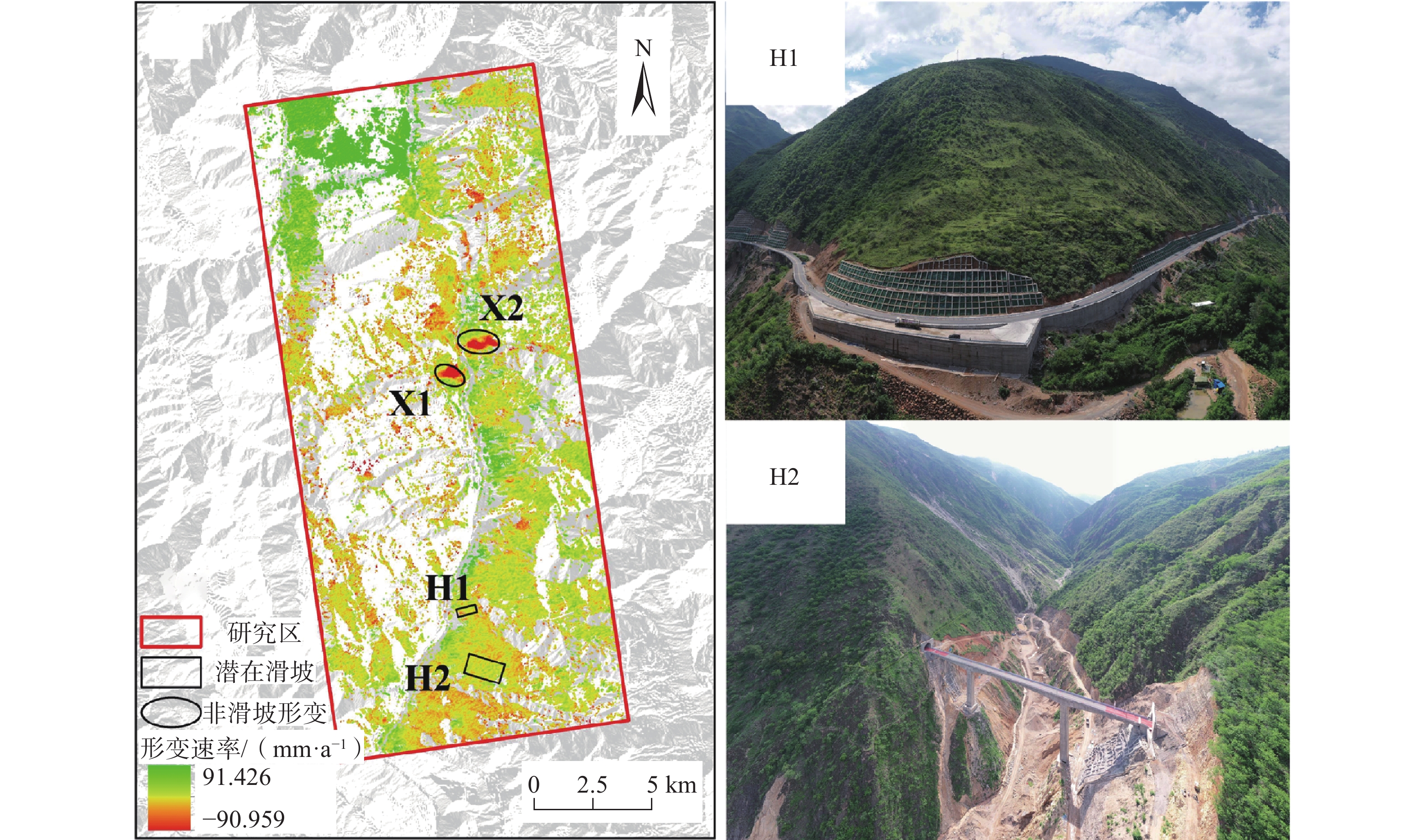
编号 形变区域名称 最大形变速率/(mm·a−1) 形变区域类别 H1 观音岩 19.846 潜在滑坡 H2 鱼坝 18.537 潜在滑坡 X1 六城村 76.259 非滑坡形变 X2 半坡 55.947 非滑坡形变
下载: 导出CSV
表 3 降轨数据库岸形变区域解译结果列表
Table 3. List of interpretation results of shore deformation region in orbit descent database
编号 形变区域名称 最大形变速率/(mm·a−1) 形变区域类别 H3 观音岩 10.726 潜在滑坡 H4 清水沟 17.605 潜在滑坡 H5 鱼坝 19.326 潜在滑坡 H6 大湾子 15.888 潜在滑坡 X3 六城村 48.871 非滑坡形变 X4 半坡 61.425 非滑坡形变
下载: 导出CSV
-
[1] 代贞伟,殷跃平,魏云杰,等. 三峡库区藕塘滑坡特征、成因及形成机制研究[J]. 水文地质工程地质,2015,42(6):145 − 153. [DAI Zhenwei,YIN Yueping,WEI Yunjie,et al. Characteristics,origin and formation mechanism of the Outang landslide in the Three Gorges Reservoir area[J]. Hydrogeology & Engineering Geology,2015,42(6):145 − 153. (in Chinese with English abstract)
[2] 张鹏,张森林,黄波林,等. 岸坡消落带岩体劣化的新生型滑坡(崩塌)隐患演化模式研究[J]. 工程地质学报,2021,29(5):1416 − 1426. [ZHANG Peng,ZHANG Senlin,HUANG Bolin,et al. Study on the evolution model of neogenic landslide (collapse) hazards in rock mass of hydro-fluctuation belt[J]. Journal of Engineering Geology,2021,29(5):1416 − 1426. (in Chinese with English abstract)
[3] 裴小龙,杨瀚文,宋东阳,等. 雅砻江中游楞古水电站夏日滑坡发育特征及稳定性分析[J]. 中国地质灾害与防治学报,2022,33(1):75 − 82. [PEI Xiaolong,YANG Hanwen,SONG Dongyang,et al. Characteristics and stability analysis of Xiari landslide at Lenggu hydropower station in the middle reach of the Yalong river[J]. The Chinese Journal of Geological Hazard and Control,2022,33(1):75 − 82. (in Chinese with English abstract)
[4] 李松林,许强,汤明高,等. 三峡库区滑坡空间发育规律及其关键影响因子[J]. 地球科学,2020,45(1):341 − 354. [LI Songlin,XU Qiang,TANG Minggao,et al. Study on spatial distribution and key influencing factors of landslides in Three Gorges Reservoir area[J]. Earth Science,2020,45(1):341 − 354. (in Chinese with English abstract)
[5] 何少其,刘元雪,杨骏堂,等. 库岸堆积层滑坡位移的分量响应模式及多因子模型[J]. 岩土力学,2020,41(8):2773 − 2784. [HE Shaoqi,LIU Yuanxue,YANG Juntang,et al. A component response mode and multi-factor model for accumulation landslide displacement induced by reservoir[J]. Rock and Soil Mechanics,2020,41(8):2773 − 2784. (in Chinese with English abstract)
[6] 廖明生,董杰,李梦华,等. 雷达遥感滑坡隐患识别与形变监测[J]. 遥感学报,2021,25(1):332 − 341. [LIAO Mingsheng,DONG Jie,LI Menghua,et al. Radar remote sensing for potential landslides detection and deformation monitoring[J]. National Remote Sensing Bulletin,2021,25(1):332 − 341. (in Chinese with English abstract)
[7] 解明礼,巨能攀,刘蕴琨,等. 崩塌滑坡地质灾害风险排序方法研究[J]. 水文地质工程地质,2021,48(5):184 − 192. [XIE Mingli,JU Nengpan,LIU Yunkun,et al. A study of the risk ranking method of landslides and collapses full text replacement[J]. Hydrogeology & Engineering Geology,2021,48(5):184 − 192. (in Chinese with English abstract)
[8] 康亚,赵超英,张勤,等. InSAR滑坡探测技术研究—以金沙江乌东德水电站段为例[J]. 大地测量与地球动力学,2018,38(10):1053 − 1057. [KANG Ya,ZHAO Chaoying,ZHANG Qin,et al. Research on the InSAR technique of landslide detection:A case study of wudongde hydropower station section,Jinshajiang[J]. Journal of Geodesy and Geodynamics,2018,38(10):1053 − 1057. (in Chinese with English abstract)
[9] 陆会燕,李为乐,许强,等. 光学遥感与InSAR结合的金沙江白格滑坡上下游滑坡隐患早期识别[J]. 武汉大学学报·信息科学版,2019,44(9):1342 − 1354. [LU Huiyan,LI Weile,XU Qiang,et al. Early detection of landslides in the upstream and downstream areas of the baige landslide,the Jinsha river based on optical remote sensing and InSAR technologies[J]. Geomatics and Information Science of Wuhan University,2019,44(9):1342 − 1354. (in Chinese with English abstract) doi: 10.13203/j.whugis20190086
[10] 闫怡秋,郭长宝,张永双,等. 基于SBAS-InSAR技术的西藏雄巴古滑坡变形特征[J]. 地质学报,2021,95(11):3556 − 3570. [YAN Yiqiu,GUO Changbao,ZHANG Yongshuang,et al. Study of the deformation characteristics of the Xiongba ancient landslide based on SBAS-InSAR method,Xizang,China[J]. Acta Geologica Sinica,2021,95(11):3556 − 3570. (in Chinese with English abstract) doi: 10.3969/j.issn.0001-5717.2021.11.027
[11] 苏晓军,张毅,贾俊,等. 基于InSAR技术的秦岭南部略阳县潜在滑坡灾害识别研究[J]. 山地学报,2021,39(1):59 − 70. [SU Xiaojun,ZHANG Yi,JIA Jun,et al. InSAR-based monitoring and identification of potential landslides in Lueyang County,the southern Qinling Mountains,China[J]. Mountain Research,2021,39(1):59 − 70. (in Chinese with English abstract)
[12] 徐帅,王尚晓,牛瑞卿. 基于InSAR技术的三峡库区巫山—奉节段潜在滑坡识别[J]. 安全与环境工程,2020,27(1):32 − 38. [XU Shuai,WANG Shangxiao,NIU Ruiqing. Identification of the potential landslide in Wushan:Fengjie in the Three Gorges Reservoir area based on InSAR technology[J]. Safety and Environmental Engineering,2020,27(1):32 − 38. (in Chinese with English abstract) doi: 10.13578/j.cnki.issn.1671-1556.2020.01.006
[13] 王振林,廖明生,张路,等. 基于时序Sentinel-1数据的锦屏水电站左岸边坡形变探测与特征分析[J]. 国土资源遥感,2019,31(2):204 − 209. [WANG Zhenlin,LIAO Mingsheng,ZHANG Lu,et al. Detecting and characterizing deformations of the left bank slope near the Jinping hydropower station with time series Sentinel-1 data[J]. Remote Sensing for Land & Resources,2019,31(2):204 − 209. (in Chinese with English abstract)
[14] 朱同同,史绪国,周超,等. 利用2016—2020年Sentinel-1数据监测与分析三峡库区树坪滑坡稳定性[J]. 武汉大学学报·信息科学版,2021,46(10):1560 − 1568. [ZHU Tongtong,SHI Xuguo,ZHOU Chao,et al. Stability monitoring and analysis of the shuping landslide in the Three Gorges area with Sentinel-1 images from 2016 to 2020[J]. Geomatics and Information Science of Wuhan University,2021,46(10):1560 − 1568. (in Chinese with English abstract)
[15] 史绪国,徐金虎,蒋厚军,等. 时序InSAR技术三峡库区藕塘滑坡稳定性监测与状态更新[J]. 地球科学,2019,44(12):4284 − 4292. [SHI Xuguo,XU Jinhu,JIANG Houjun,et al. Slope stability state monitoring and updating of the outang landslide,Three Gorges area with time series InSAR analysis[J]. Earth Science,2019,44(12):4284 − 4292. (in Chinese with English abstract)
[16] LIAO M S,BALZ T,ZHANG L,et al. Characterization of landslide deformations in Three Gorges area using multiple InSAR data stacks[J]. Remote Sensing,2013,5(6):2704 − 2719. doi: 10.3390/rs5062704
[17] ZHOU C,CAO Y,YIN K L,et al. Landslide characterization applying sentinel-1 images and InSAR technique:The muyubao landslide in the Three Gorges Reservoir area,China[J]. Remote Sensing,2020,12:3385. doi: 10.3390/rs12203385
[18] LIU P,LI Z H,HOEY T,et al. Using advanced InSAR time series techniques to monitor landslide movements in Badong of the Three Gorges Region,China[J]. International Journal of Applied Earth Observation and Geoinformation,2013,21:253 − 264. doi: 10.1016/j.jag.2011.10.010
[19] 佘雅文,付广裕,赵倩,等. 白鹤滩水电站蓄水引起重力与库仑应力变化的模拟研究[J]. 地球物理学报,2021,64(6):1925 − 1936. [SHE Yawen,FU Guangyu,ZHAO Qian,et al. Simulating changes of gravity and Coulomb stress caused by the impoundment of the Baihetan hydropower station[J]. Chinese Journal of Geophysics,2021,64(6):1925 − 1936. (in Chinese with English abstract) doi: 10.6038/cjg2021O0163
[20] 冯文凯,易小宇,白慧林,等. 白鹤滩水库初次蓄水对双河段岸坡稳定性的影响预测分析[J]. 科学技术与工程,2021,21(1):346 − 352. [FENG Wenkai,YI Xiaoyu,BAI Huilin,et al. Prediction and analysis of influence of the first impoundment of Baihetan Reservoir on the bank slope stability of Shuanghe river section[J]. Science Technology and Engineering,2021,21(1):346 − 352. (in Chinese with English abstract)
[21] 王哲,赵超英,刘晓杰,等. 西藏易贡滑坡演化光学遥感分析与InSAR形变监测[J]. 武汉大学学报·信息科学版,2021,46(10):1569 − 1578. [WANG Zhe,ZHAO Chaoying,LIU Xiaojie,et al. Evolution analysis and deformation monitoring of yigong landslide in Xizang with optical remote sensing and InSAR[J]. Geomatics and Information Science of Wuhan University,2021,46(10):1569 − 1578. (in Chinese with English abstract) doi: 10.13203/j.whugis20210168
[22] 黄观文,王家兴,杜源,等. 顾及降雨及库水位因素的滑坡时滞分析与预测—以三峡库区新铺滑坡为例[J]. 地球科学与环境学报,2021,43(3):621 − 631. [HUANG Guanwen,WANG Jiaxing,DU Yuan,et al. Time-delay analysis and prediction of landslide considering precipitation and reservoir water level:A case study of Xinpu landslide in Three Gorges Reservoir area,China[J]. Journal of Earth Sciences and Environment,2021,43(3):621 − 631. (in Chinese with English abstract)
[23] HUANG H N, ZHANG X B, LI Z R, et al. Stability evaluation at Xishan Loess landslide using InSAR technique applying ascending and descending SAR data[C]//2021: 034519.
[24] BERARDINO P,FORNARO G,LANARI R,et al. A new algorithm for surface deformation monitoring based on small baseline differential SAR interferograms[J]. IEEE Transactions on Geoscience and Remote Sensing,2002,40(11):2375 − 2383. doi: 10.1109/TGRS.2002.803792
[25] DAI F,JIANG P,XU N W,et al. Focal mechanism determination for microseismic events and its application to the left bank slope of the Baihetan hydropower station in China[J]. Environmental Earth Sciences,2018,77(7):268. doi: 10.1007/s12665-018-7443-1
[26] 喜文飞. 滇东北山区无人机遥感影像预处理方法及滑坡特征识别研究[D]. 昆明: 云南师范大学, 2019
XI Wenfei. Study on remote sensing image preprocessing method and landslide feature identification of UAV in northeast Yunnan Mountain area[D]. Kunming: Yunnan Normal University, 2019. (in Chinese with English abstract)
[27] 张欣,王运生. 白鹤滩水电站库区小江断裂带活动性研究[J]. 工程地质学报,2017,25(2):531 − 540. [ZHANG Xin,WANG Yunsheng. Activities of Xiaojiang fault zone in Baihetan hydropower station reservoir[J]. Journal of Engineering Geology,2017,25(2):531 − 540. (in Chinese with English abstract)
-


图(11)
表(3)
计量
- 文章访问数: 4492
- PDF下载数: 194
- 施引文献: 0