

Assessment of rockfall susceptibility along the expressway based on the CF-AHP coupling model: A case study of the Tucheng-Wanglong section of the Rongzun expressway
-
摘要:
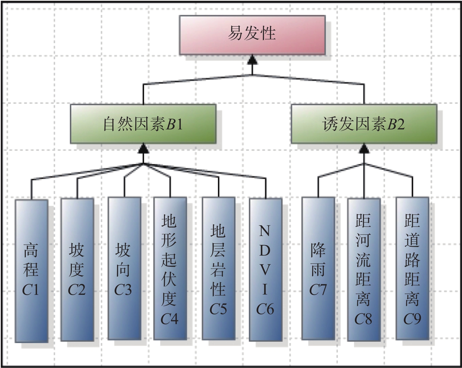
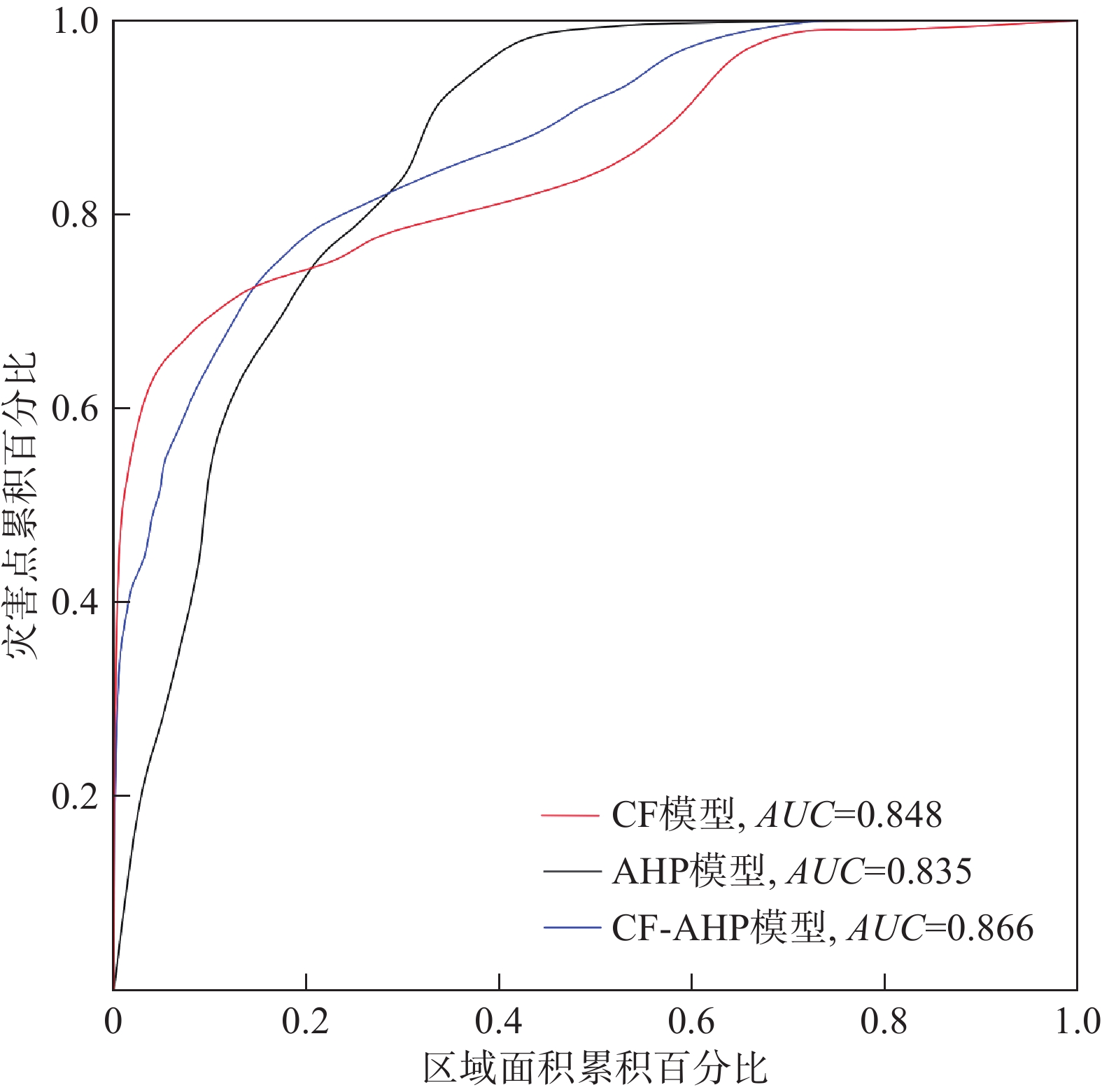
蓉遵高速公路(土城—旺隆段)沿线崩塌频繁发生,威胁公路安全甚至人类的生命财产安全。文章通过实地调查蓉遵高速公路(土城-旺隆段)崩塌地质灾害的影响因素,构建了9个影响因子,分别是地形起伏度、高程、归一化植被指数、坡向、地层岩性、距道路距离、距河流距离、坡度及降雨量。采用确定性系数模型(certain factors,CF)、层次分析法(analytic hierarchy process,AHP)及耦合模型(CF-AHP)对研究区进行崩塌地质灾害易发性评价,并分别采用崩塌地质灾害点频率统计和成功率曲线对3种模型的评价精度进行检验。结果表明,CF、AHP和CF-AHP的AUC预测精度分别为0.848,0.835,0.866,且3种评价模型得到的崩塌地质灾害的高、中易发区频率比值占总频率比值均超过70%。 3种模型精确度由大到小分别为CF-AHP、CF、AHP模型,说明CF-AHP模型的滑坡预测优于单一的CF、AHP模型,能精确地评价蓉遵高速公路(土城-旺隆段)崩塌地质灾害易发性,为公路沿线区域崩塌灾害的防灾减灾提供决策依据。
-
关键词:
- 崩塌地质灾害 /
- 高速公路 /
- 易发性评价 /
- CF-AHP耦合模型
Abstract:Frequent geological hazards have occurred along the Rongzun Expressway (Tucheng - Wanglong section, posing a threat to the safety of the highway and even human life and property. This study investigated the causes of rockfall along the expressway and identified nine influencing factors, including terrain fluctuation, elevation, normalized difference vegetation index (NDVI), slope direction, lithology, distance from the road, distance from the river, slope, and rainfall. The certainty factor model (CF), analytic hierarchy process (AHP), and coupling model (CF-AHP) were used to evaluate the susceptibility of geological hazard in the study area, and the accuracy of the three models was tested using the distribution of rockfalls at various levels and the success rate curve. The results indicated that the AUC evaluation accuracy of CF, AHP and CF-AHP was 0.848, 0.835 and 0.866, respectively. The frequency ratios of high and moderate prone areas of geohazards obtained by the three evaluation models accounted for more than 70% of the total frequency ratios. The accuracy of the three models in descending order is CF-AHP, CF, AHP models, respectively. This indicates that the CF-AHP model is better than the single CF and AHP models in geohazard prediction and can accurately evaluate the geohazard susceptibility of expressway. It provides a decision-making basis for disaster prevention and mitigation of regional rockfall disaster along the highway.
-
Key words:
- rockfall geological hazard /
- expressway /
- susceptibility evaluation /
- the CF-AHP model
-

-
表 1 判断矩阵标度及其含义
Table 1. Judgment matrix scale and its meaning
标度值 含义 1 表示两个因素相比,具有相同重要性 3 表示两个因素相比,前者比后者稍重要 5 表示两个因素相比,前者比后者明显重要 7 表示两个因素相比,前者比后者强烈重要 9 表示两个因素相比,前者比后者极端重要 2,4,6,8 表示上述相邻判断的中间值 倒数 与上述影响情况相反  下载: 导出CSV
表 2 评价因子分级及CF值
Table 2. Classification of evaluation factors and CF values of each grade
指标因子 分级 面积/km2 灾害点数/个 点密度/(个·km-2) CF值 高程/m 222~325 7.277 0 0 −1 >325~407 4.458 6 1.345986 0.297557 >407~488 4.587 10 2.179932 0.566281 >488~581 3.609 4 1.10834 0.146942 >581~790 1.451 0 0 −1 坡度/(°) 0~10 2.962 0 0 −1 >10~20 4.497 0 0 −1 >20~30 6.335 3 0.473552 −0.49914 >30~40 4.993 11 2.202996 0.570822 >40 2.595 6 2.312406 0.591128 地形起伏度/m 152~285 1.067 0 0 −1 286~362 6.290 2 0.31796 −0.66371 363~439 6.170 3 0.486192 −0.48577 440~526 5.431 15 2.762126 0.657699 527~672 2.440 0 −1 坡向/(°) 平面 0.002 0 0 −1 北 2.435 3 1.231831 0.23246 东北 6.026 10 1.659613 0.430302 东 5.409 5 0.924385 −0.02231 东南 3.192 1 0.313254 −0.66868 南 1.951 1 0.512505 −0.45794 西南 0.556 0 0 −1 西 0.943 0 0 −1 西北 0.868 0 0 −1 地层 J3p1 0.208 0 0 −1 Kjd1 13.538 11 0.81254 −0.14061 Kjd2 3.333 5 1.500285 0.369801 J3p2 4.086 4 0.978953 0.034193 归一化植被指数 −0.0897~0.0962 1.485 0 0 −1 0.0963~0.2405 2.528 0 0 −1 0.2406~0.3432 3.047 4 1.312982 0.2799 0.3433~0.419 6.817 7 1.026905 0.079293 0.4191~0.534 7.309 9 1.231375 0.232177 距道路距离/m 0~50 2.858 6 2.099076 0.549574 >50~100 2.863 5 1.746481 0.458638 >100~150 2.856 4 1.400707 0.324999 >150~200 2.806 3 1.069061 0.115599 >200~250 2.646 1 0.377929 −0.60028 >250 7.127 1 0.14031 −0.8516 距河流距离/m 0~100 5.868 0 0 −1 >100~200 2.928 3 1.024695 0.077307 >200~300 2.878 8 2.779515 0.659841 >300~400 2.824 8 2.832661 0.666223 400~500 2.713 1 0.36865 −0.61009 >500 3.933 0 −1 降雨量/mm 0~800 5.108 4 1.379483 −0.17168 >800~900 8.063 5 0.620109 −0.34413 >900~1000 7.974 11 0.783162 0.314614
下载: 导出CSV
表 3 中间层(B)判断矩阵
Table 3. Judgment matrix for intermediate layer (B)
易发性 诱发因素B2 自然因素B1 权重 诱发因素B2 1 0.3333 0.25 自然因素B1 3 1 0.75
下载: 导出CSV
表 4 指标层(B1)判断矩阵
Table 4. Judgment matrix for indicator layer (B1)
自然因素B1 高程C1 坡度C2 坡向C3 地形起伏度C4 地层岩性C5 归一化植被指数 C6 权重 高程C1 1 0.3333 3 0.3333 0.25 3 0.1017 坡度C2 3 1 5 0.5 0.3333 3 0.1815 坡向C3 0.3333 0.2 1 0.2 0.2 2 0.0543 地形起伏度C4 3 2 5 1 0.5 4 0.247 地层岩性C5 4 3 5 2 1 5 0.3673 NDVI C6 0.3333 0.3333 0.5 0.25 0.2 1 0.0482
下载: 导出CSV
表 5 指标层(B2)判断矩阵
Table 5. Judgment matrix for indicator layer (B2)
诱发因素B2 降雨C7 距河流距离C8 距道路距离C9 权重 降雨量C7 1 3 1 0.4286 距河流距离C8 0.3333 1 0.3333 0.1429 距道路距离C9 1 3 1 0.4286
下载: 导出CSV
表 6 各因子的权重
Table 6. Influence weight of each factor
备选方案 地层岩性C5 地形起伏度C4 坡度C2 降雨量C7 距道路距离C9 高程C1 坡向C3 NDVI C6 距河流距离C8 权重 0.2755 0.1852 0.1361 0.1071 0.1071 0.0763 0.0407 0.0361 0.0357
下载: 导出CSV
表 7 易发性评价结果
Table 7. Summary table of geohazard susceptibility for three models
易发性等级 CF AHP CF-AHP 栅格数 百分比/% 栅格数 百分比/% 栅格数 百分比/% 极低易发区 4482 19.4278 4156 18.0147 4826 20.9189 低易发区 6934 30.0564 7105 30.7976 8028 34.7984 中易发区 8409 36.4499 7853 34.0399 7029 30.4681 高易发区 3245 14.0659 3956 17.1478 3187 13.8145
下载: 导出CSV
表 8 地质灾害易发性评价结果检验
Table 8. Verification of geohazards susceptibility assessment results
易发性等级 灾害点百分比/% CF AHP CF-AHP 极低易发区 0 0 0 低易发区 0 5 0 中易发区 25 25 15 高易发区 75 70 85
下载: 导出CSV
-
[1] 覃乙根,杨根兰,鲁鲲鹏,等. 贵州寨子危岩崩塌风险定量评价研究[J]. 人民长江,2019,50(10):113 − 119. [QIN Yigen,YANG Genlan,LU Kunpeng,et al. Quantitative risk assessment for Zhaizi rockfall in Guizhou Province[J]. Yangtze River,2019,50(10):113 − 119. (in Chinese with English abstract)
QIN Yigen, YANG Genlan, LU Kunpeng, et al. Quantitative risk assessment for Zhaizi rockfall in Guizhou Province[J]. Yangtze River, 2019, 50(10): 113-119. (in Chinese with English abstract)
[2] 谈树成,刘雪斌,谢亚亚,等. 某拟建高速公路地质灾害易发性评价[J]. 水土保持研究,2019,26(3):373 − 380. [TAN Shucheng,LIU Xuebin,XIE Yaya,et al. Assessment on susceptibility of geohazard for a proposed expressway[J]. Research of Soil and Water Conservation,2019,26(3):373 − 380. (in Chinese with English abstract)
TAN Shucheng, LIU Xuebin, XIE Yaya, et al. Assessment on susceptibility of geohazard for a proposed expressway[J]. Research of Soil and Water Conservation, 2019, 26(3)373-380(in Chinese with English abstract)
[3] 崔志超,王俊豪,崔传峰,等. 基于层次分析法和模糊数学相结合的甘肃东乡八丹沟泥石流易发性评价[J]. 中国地质灾害与防治学报,2020,31(1):44 − 50. [CUI Zhichao,WANG Junhao,CUI Chuanfeng,et al. Evaluation of the susceptibility of debris flow in Badan Gully of Dongxiang County of Gansu based on AHP and Fuzzy mathematics[J]. The Chinese Journal of Geological Hazard and Control,2020,31(1):44 − 50. (in Chinese with English abstract)
CUI Zhichao, WANG Junhao, CUI Chuanfeng, et al. Evaluation of the susceptibility of debris flow in Badan Gully of Dongxiang County of Gansu based on AHP and Fuzzy mathematics[J]. The Chinese Journal of Geological Hazard and Control, 2020, 31(1)44-50(in Chinese with English abstract)
[4] 刘宇恒,邓辉,熊倩莹. 基于层次分析法的茂县斜坡地质灾害易发性评价[J]. 长江科学院院报,2017,34(5):31 − 35. [LIU Yuheng,DENG Hui,XIONG Qianying. AHP-based evaluation of slope geo-hazard susceptibility of Maoxian County,Sichuan,China[J]. Journal of Yangtze River Scientific Research Institute,2017,34(5):31 − 35. (in Chinese with English abstract) doi: 10.11988/ckyyb.20160155
LIU Yuheng, DENG Hui, XIONG Qianying. AHP-based evaluation of slope geo-hazard susceptibility ofMaoxian County, Sichuan, China[J]. Journal of Yangtze River Scientific Research Institute, 2017, 34(5)31-35(in Chinese with English abstract) doi: 10.11988/ckyyb.20160155
[5] 尚敏,马锐,张英莹,等. 基于GIS的证据权重法的崩塌敏感性分析研究[J]. 工程地质学报,2018,26(5):1211 − 1218. [SHANG Min,MA Rui,ZHANG Yingying,et al. GIS based weights of evidence method for rock fall susceptibility[J]. Journal of Engineering Geology,2018,26(5):1211 − 1218. (in Chinese with English abstract)
SHANG Min, MA Rui, ZHANG Yingying, et al. GIS based weights of evidence method for rock fall susceptibility[J]. Journal of Engineering Geology, 2018, 26(5)1211-1218(in Chinese with English abstract)
[6] 谭玉敏,郭栋,白冰心,等. 基于信息量模型的涪陵区地质灾害易发性评价[J]. 地球信息科学学报,2015,17(12):1554 − 1562. [TAN Yumin,GUO Dong,BAI Bingxin,et al. Geological hazard risk assessment based on information quantity model in Fuling District,Chongqing City,China[J]. Journal of Geo-Information Science,2015,17(12):1554 − 1562. (in Chinese with English abstract)
TAN Yumin, GUO Dong, BAI Bingxin, et al. Geological hazard risk assessment based on information quantity model in Fuling district, Chongqing city, China[J]. Journal of Geo-Information Science, 2015, 17(12)1554-1562(in Chinese with English abstract)
[7] 覃乙根,杨根兰,江兴元,等. 基于确定性系数模型与逻辑回归模型耦合的地质灾害易发性评价—以贵州省开阳县为例[J]. 科学技术与工程,2020,20(1):96 − 103. [QIN Yigen,YANG Genlan,JIANG Xingyuan,et al. Geohazard susceptibility assessment based on integrated certainty factor model and logistic regression model for Kaiyang,China[J]. Science Technology and Engineering,2020,20(1):96 − 103. (in Chinese with English abstract) doi: 10.3969/j.issn.1671-1815.2020.01.015
QIN Yigen, YANG Genlan, JIANG Xingyuan, et al. Geohazard susceptibility assessment based on integrated certainty factor model and logistic regression model for Kaiyang, China[J]. Science Technology and Engineering, 2020, 20(1)96-103(in Chinese with English abstract)) doi: 10.3969/j.issn.1671-1815.2020.01.015
[8] 向喜琼,黄润秋. 基于GIS的人工神经网络模型在地质灾害危险性区划中的应用[J]. 中国地质灾害与防治学报,2000,11(3):23 − 27. [XIANG Xiqiong,HUANG Runqiu. Application of GIS-based artificial Neural Networks on assessment of geohazards risk[J]. The Chinese Journal of Geological Hazard and Control,2000,11(3):23 − 27. (in Chinese with English abstract)
Xiang Xiqiong, Huang Runqiu. Application of GIS-based artificial Neural Networks on assessment of geohazards risk[J]. The Chinese Journal of Geological Hazard and Control, 2000, 11(3): 23-27. (in Chinese with English abstract))
[9] 黄发明,殷坤龙,蒋水华,等. 基于聚类分析和支持向量机的滑坡易发性评价[J]. 岩石力学与工程学报,2018,37(1):156 − 167. [HUANG Faming,Yin Kunlong,Jiang Shuihua,et al. Landslide susceptibility assessment based on clustering analysis and support vector machine[J]. Chinese Journal of Rock Mechanics and Engineering,2018,37(1):156 − 167. (in Chinese with English abstract)
Huang Faming, Yin Kunlong, Jiang Shuihua, et al. Landslide susceptibility assessment based on clustering analysis and support vector machine[J]. Chinese Journal of Rock Mechanics and Engineering, 2018, 37(1): 156-167. (in Chinese with English abstract))
[10] 吴润泽,胡旭东,梅红波,等. 基于随机森林的滑坡空间易发性评价—以三峡库区湖北段为例[J]. 地球科学,2021(1):321 − 330. [WU Runze,HU Xudong,MEI Hongbo,et al. Spatial susceptibility assessment of landslides based on random forest:A case study from Hubei section in the Three Gorges Reservoir area[J]. Earth Science,2021(1):321 − 330. (in Chinese with English abstract)
WU Runze, HU Xudong, MEI Hongbo, et al. Spatial susceptibility assessment of landslides based on random forest: a case study from Hubei section in the Three Gorges Reservoir area[J]. Earth Science, 2021(1): 321-330. (in Chinese with English abstract)
[11] 胡涛,樊鑫,王硕,等. 基于逻辑回归模型和3S技术的思南县滑坡易发性评价[J]. 地质科技通报,2020(2):113 − 121. [HU Tao,FAN Xin,WANG Shuo,et al. Landslide susceptibility evaluation of Sinan County using logistics regression model and 3S technology[J]. Geological Science and Technology Information,2020(2):113 − 121. (in Chinese with English abstract)
HU Tao, FAN Xin, WANG Shuo, et al. Landslide susceptibility evaluation of Sinan County using logistics regression model and 3S technology[J]. Geological Science and Technology Information, 2020(2): 113-121. (in Chinese with English abstract)
[12] 覃乙根,杨根兰,谢金,等. 贵州省开阳县斜坡地质灾害孕灾因子敏感性分析[J]. 煤田地质与勘探,2020,48(4):190 − 198. [QIN Yigen,YANG Genlan,XIE Jin,et al. Sensitivity analysis of disaster-pregnant environmental factors for slope geological hazards in Kaiyang County,Guizhou Province[J]. Coal Geology & Exploration,2020,48(4):190 − 198. (in Chinese with English abstract)
Qin Yigen, Yang Genlan, Xie Jin, et al. Sensitivity analysis of disaster-pregnant environmental factors for slope geological hazards in Kaiyang County, Guizhou Province[J]. Coal Geology & Exploration, 2020, 48(4): 190-198. (in Chinese with English abstract)
[13] 刘光辉,刘汉湖,姚昆,等. 基于证据权法与确定系数法的滑坡危险区划对比分析—以虹口乡为例[J]. 物探化探计算技术,2016,38(6):848 − 853. [LIU Guanghui,LIU Hanhu,YAO Kun,et al. Based on the weights of evidence method and certainty factor method of landslide danger division comparative analysis:A case study in Hongkou,China[J]. Computing Techniques for Geophysical and Geochemical Exploration,2016,38(6):848 − 853. (in Chinese with English abstract) doi: 10.3969/j.issn.1001-1749.2016.06.21
LIU Guanghui, LIU Hanhu, YAO Kun, et al. Based on the weights of evidence method and certainty factor method of landslide danger division comparative analysis: -a case study in Hongkou, chine[J]. Computing Techniques for Geophysical and Geochemical Exploration, 2016, 38(6)848-853(in Chinese with English abstract) doi: 10.3969/j.issn.1001-1749.2016.06.21
[14] 李益敏,李驭豪,赵志芳. 基于确定性系数模型的泸水市泥石流易发性评价[J]. 水土保持研究,2019,26(4):336 − 342. [LI Yimin,LI Yuhao,ZHAO Zhifang. Assessment on susceptibility of debris flow in Lushui based on the certain factor model[J]. Research of Soil and Water Conservation,2019,26(4):336 − 342. (in Chinese with English abstract)
LI Yimin, LI Yuhao, ZHAO Zhifang. Assessment on susceptibility of debris flow in Lushui based on the certain factor model[J]. Research of Soil and Water Conservation, 2019, 26(4)336-342(in Chinese with English abstract)
[15] 杨栓成,王运生. 基于GIS的涪江上游南坝-水晶流域滑坡危险性评价[J]. 中国地质灾害与防治学报,2018,29(6):15 − 22. [YANG Shuancheng,WANG Yunsheng. GIS-based landslide risk assessment along the Nanba-Shuijing reaches in the Fujiang River[J]. The Chinese Journal of Geological Hazard and Control,2018,29(6):15 − 22. (in Chinese with English abstract)
YANG Shuancheng, WANG Yunsheng. GIS-based landslide risk assessment along the Nanba-Shuijing reaches in the Fujiang River[J]. The Chinese Journal of Geological Hazard and Control, 2018, 29(6): 15-22. (in Chinese with English abstract)
[16] 李益敏,袁静,蒋德明,等. 基于GIS的高山峡谷区滑坡灾害危险性评价—以泸水市为例[J]. 水土保持研究,2021,28(3):355 − 363. [LI Yimin,YUAN Jing,JIANG Deming,et al. GIS-based risk assessment of landslide disaster in high mountain valley:Taking Lushui City as an example[J]. Research of Soil and Water Conservation,2021,28(3):355 − 363. (in Chinese with English abstract)
LI Yimin, YUAN Jing, JIANG Deming, et al. GIS-based risk assessment of landslide disaster in high mountain valley—taking Lushui city as an example[J]. Research of Soil and Water Conservation, 2021, 28(3): 355-363. (in Chinese with English abstract)
[17] 李萍,叶辉,谈树成. 基于层次分析法的永德县地质灾害易发性评价[J]. 水土保持研究,2021,28(5):394 − 399. [LI Ping,YE Hui,TAN Shucheng. Evaluation of geological hazards in Yongde County based on analytic hierarchy process[J]. Research of Soil and Water Conservation,2021,28(5):394 − 399. (in Chinese with English abstract)
LI Ping, YE Hui, TAN Shucheng. Evaluation of geological hazards in Yongde County based on analytic hierarchy process[J]. Research of Soil and Water Conservation, 2021, 28(5): 394-399. (in Chinese with English abstract)
[18] 刘建强,许强,郑光,等. 贵州省鸡场滑坡地下水化学特征反映的水-岩(土)作用[J]. 水文地质工程地质,2023,50(2):132 − 140. [LIU Jianqiang,XU Qiang,ZHENG Guang,et al. Water-rock/soil interaction reflected by the chemical characteristics of groundwater of Jichang landslide in Guizhou Province[J]. Hydrogeology & Engineering Geology,2023,50(2):132 − 140. (in Chinese with English abstract) doi: 10.16030/j.cnki.issn.1000-3665.202103009
LIU Jianqiang, XU Qiang, ZHENG Guang, et al. Water-rock/soil interaction reflected by the chemical characteristics of groundwater of Jichang landslide in Guizhou Province[J]. Hydrogeology & Engineering Geology, 2023, 50(2): 132-140. (in Chinese with English abstract) doi: 10.16030/j.cnki.issn.1000-3665.202103009
[19] 黄煜,谢婉丽,刘琦琦,等. 基于GIS与MaxEnt模型的滑坡易发性评价—以铜川市中部城区为例[J]. 西北地质,2023,56(1):266 − 275. [HUANG Yu,XIE Wanli,LIU Qiqi,et al. Landslide susceptibility assessment based on GIS and MaxEnt model:Example from central districts in Tongchuan city[J]. Northwestern Geology,2023,56(1):266 − 275. (in Chinese with English abstract) doi: 10.12401/j.nwg.2022001
HUANG Yu, XIE Wanli, LIU Qiqi, et al. Landslide susceptibility assessment based on GIS and MaxEnt model: example from central districts in Tongchuan city[J]. Northwestern Geology, 2023, 56(1): 266-275. (in Chinese with English abstract) doi: 10.12401/j.nwg.2022001
[20] 唐军峰,唐雪梅,周基,等. 滑坡堆积体变形失稳机制—以贵州剑河县东岭信滑坡为例[J]. 吉林大学学报(地球科学版),2022,52(2):503 − 516. [TANG Junfeng,TANG Xuemei,ZHOU Ji,et al. Deformation and instability mechanism of landslide accumulation:A case study of Donglingxin landslide accumulation in Jianhe County,Guizhou Province[J]. Journal of Jilin University (Earth Science Edition),2022,52(2):503 − 516. (in Chinese with English abstract)
TANG Junfeng, TANG Xuemei, ZHOU Ji, et al. Deformation and instability mechanism of landslide accumulation: a case study of donglingxin landslide accumulation in Jianhe County, Guizhou Province[J]. Journal of Jilin University (Earth Science Edition), 2022, 52(2): 503-516. (in Chinese with English abstract)
[21] 赵无忌,殷志强,马吉福,等. 黄河上游贵德盆地席芨滩巨型滑坡发育特征及地貌演化[J]. 地质论评,2016,62(3):709 − 721. [ZHAO Wuji,YIN Zhiqiang,MA Jifu,et al. Multi-stage development characteristics and geomorphic evolution process of the Xijitan super large landslide in the Guide basin,upper reaches of Yellow River[J]. Geological Review,2016,62(3):709 − 721. (in Chinese with English abstract)
Zhao Wuji, Yin Zhiqiang, Ma Jifu, et al. Multi-stage development characteristics and geomorphic evolution process of the xijitan super large landslide in the guide basin, upper reaches of Yellow River[J]. Geological Review, 2016, 62(3): 709-721. (in Chinese with English abstract)
-


图(5)
表(8)
计量
- 文章访问数: 649
- PDF下载数: 88
- 施引文献: 0