

Spatial-temporal variations of bare flats in the Qinjiang River estuary, Maowei Sea
-
摘要:
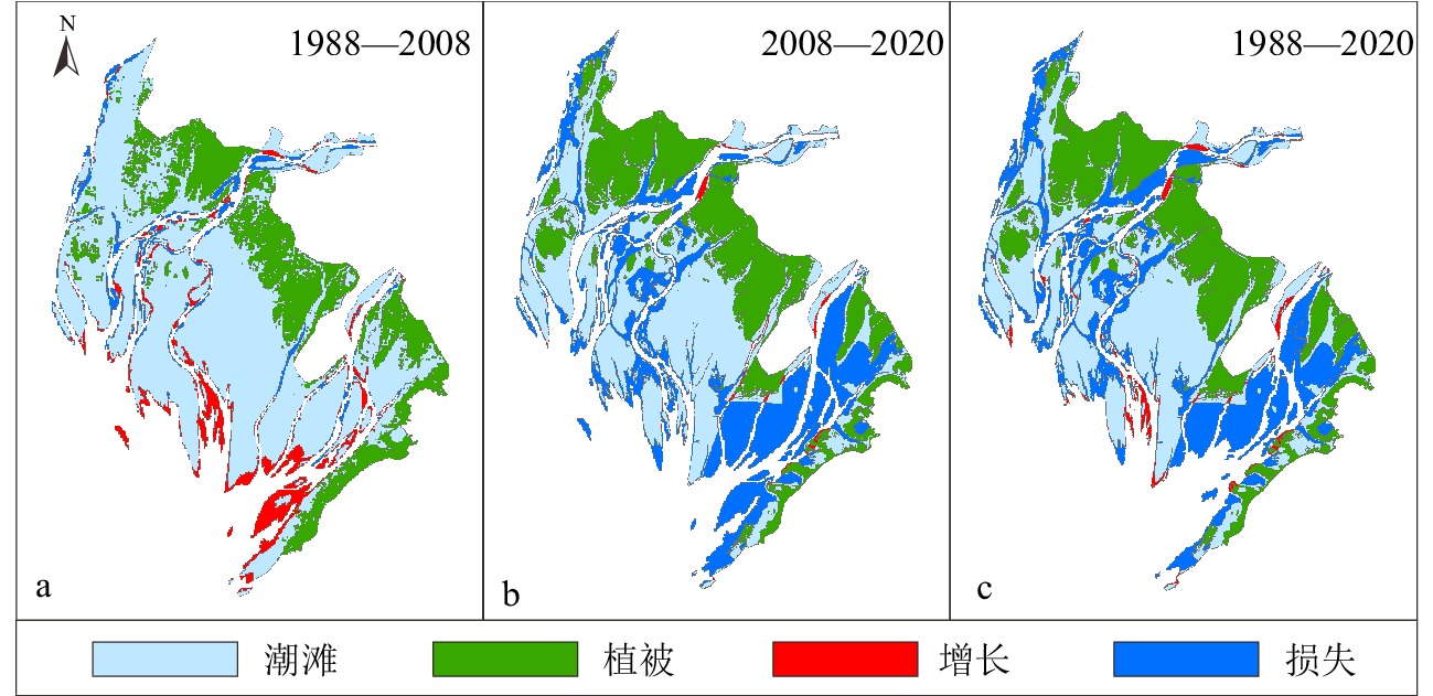
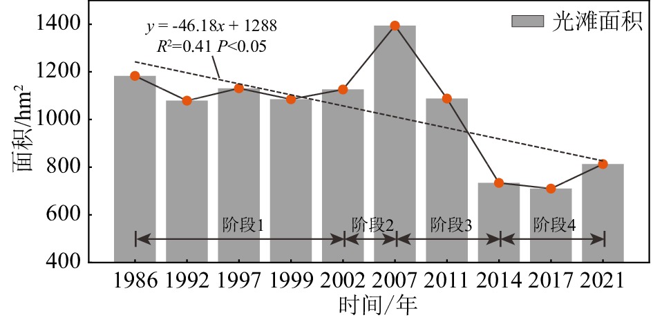
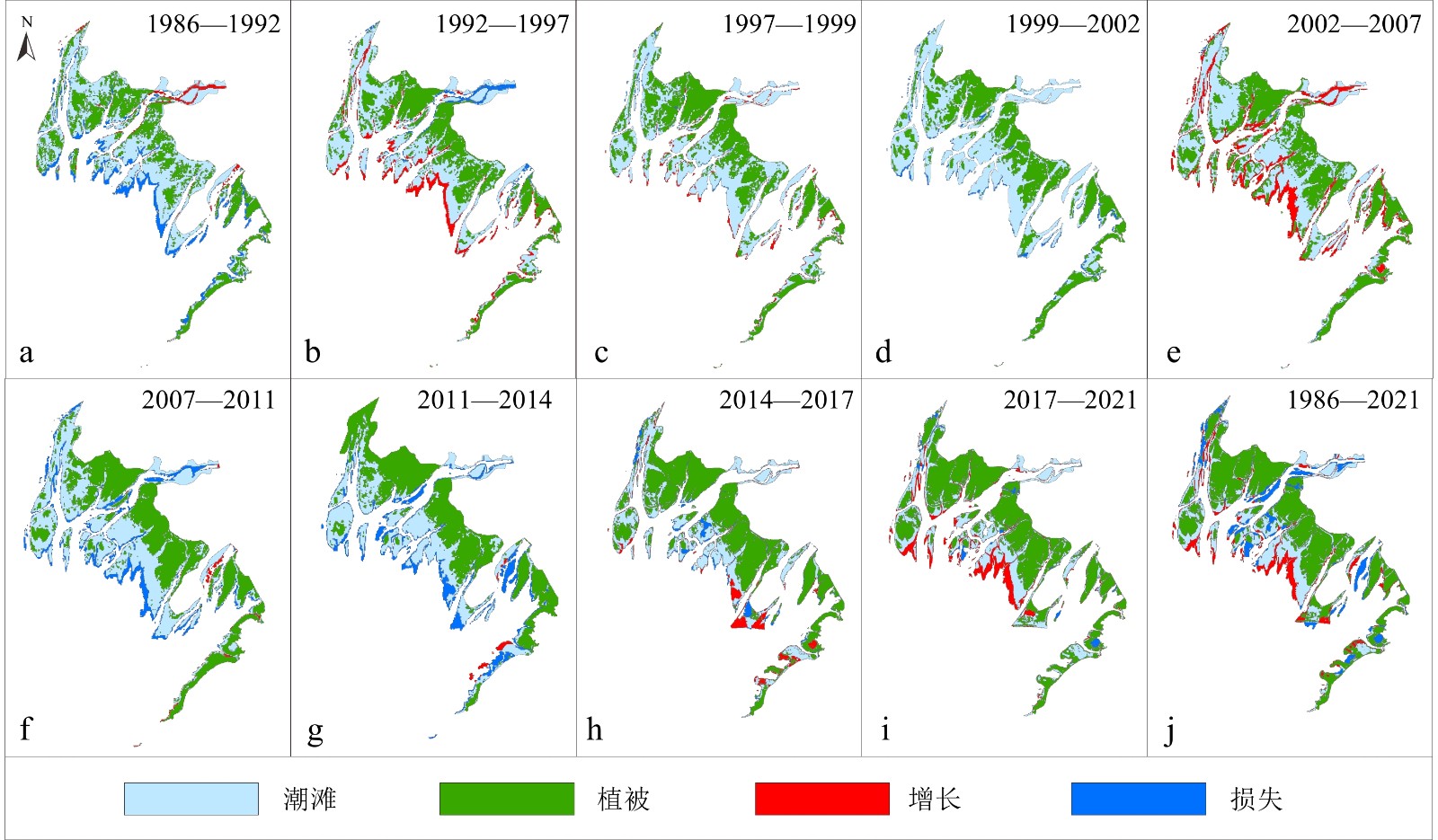
河口潮滩一般由生长于中高潮滩的植被和植被前缘光滩(裸滩)构成,光滩的时空变化直接关联潮滩冲淤及植被演替状态。本文基于Landsat 5 TM及Sentinel-2 MSI等多期遥感影像,利用随机森林分类算法与数字岸线分析系统探讨茅尾海钦江河口光滩在1986—2021年期间的变化过程。结果表明:①近40年钦江河口光滩面积总体呈现明显损失的状态,可分为1986—2002年冲淤平衡、2002—2007年快速淤积、2007—2014年急剧降低和2014—2021年缓慢淤涨4个阶段;②光滩淤积的区域主要分布于钦江沙井河口口门及内侧河槽与潮汐通道边缘,侵蚀出现在钦江沙井河口及钦江沙冲河口航道及潮沟区域;③茅尾海清淤工程是引起钦江河口光滩自2008年到2014年面积减少的直接因素,潮间带植被扩张和2015年之后大范围生蚝养殖引起的水动力减弱导致光滩向海淤涨。当前海平面上升未对光滩造成明显影响,但入海泥沙的变化一定程度上影响光滩冲淤演变。本研究可为区域河口潮滩资源的可持续高效利用提供部分理论与技术支撑。
Abstract:Estuarine tidal flats generally consist of vegetated wetlands in upper-middle intertidal zones and fringed bare flats in middle-lower intertidal zones. Spatial-temporal variations of bare flats directly regulate geomorphic erosions-accretions and vegetation successions of the whole tidal flats. Based on multi-satellite remote sensing imageries from Landsat 5/8 TM/OLI and Sentinel-2 MSI collections, random forest classification algorithm and Digital Shoreline Analysis System were used to examine the variations and characteristics of bare intertidal flats in the Qinjiang River estuary (QRE), Maowei Sea (MWS) of Beibu Gulf in 1986—2021. Results indicate that, (1) the overall area of bare flats in the QRE has shown obvious losses during the past four decades, which can be divided into four stages: maintained equilibrium of erosion-accumulation between 1986—2002, accumulated rapidly between 2002—2007, declined sharply between 2007—2014 and slowly deposited between 2014—2021. (2) Tidal flat accretions distributed mainly in the secondary Shajing outlet (SJO) and its inner channel of the QRE along the edges of tidal channels, while erosions occurred in the secondary SJO, Shachong outlet (SCO) and inner tidal channels. (3) Dredging projects in the MWS were the direct driven force that triggered the losses of bare intertidal flats in the QRE from 2008 to 2014, and the expansions of intertidal vegetation and weakened hydrodynamics followed by extensive oyster cultivations after 2015 caused seaward progradation of the bare flats. In addition, the modern sea-level rise has not significantly affected the dynamics of bare flats, and the losses were partly due to the reduced riverine suspended sediment load into the MWS. This study provided theoretical and technical supports for the sustainable and efficient utilizations of estuarine tidal flats.
-

-
表 1 遥感影像信息及对应潮位
Table 1. Satellite remote sensing imageries and corresponding tide levels
序号 成像日期 卫星 分辨率/m 潮位/m 影像分组 1 1988-06-06 Landsat 5 TM 30 1.62
中潮平均低潮位2 2008-05-12 Landsat 5 TM 30 1.63 3 2020-04-15 Sentinel-2 MSI 10 1.60 4 1986-08-04 Landsat 5 TM 30 3.01 平均中潮位 5 1992-10-23 Landsat 5 TM 30 2.88 6 1997-08-02 Landsat 5 TM 30 2.98 7 1999-09-25 Landsat 5 TM 30 2.92 8 2002-11-04 Landsat 5 TM 30 2.97 9 2007-07-29 Landsat 5 TM 30 2.79 10 2011-05-29 Landsat 5 TM 30 2.74 11 2014-06-14 Landsat 8 OLI 30 2.97 12 2017-04-01 Sentinel-2 MSI 10 2.98 13 2021-07-24 Sentinel-2 MSI 10 3.03  下载: 导出CSV
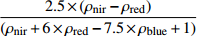
表 2 用于分类的光谱指数及计算公式
Table 2. Spectral indices used for classification and the calculation formula
下载: 导出CSV
表 3 检验区地物面积提取结果
Table 3. Extraction results of ground object area in the inspection area
卫星型号 成像时间 检验区1 检验区2 检验区面积/hm2 植被/hm2 光滩/hm2 光滩面积差值
占比/%检验区
面积/hm2植被
/hm2光滩
/hm2光滩面积
差值/%Sentinel-2 MSI 2021/07/24 171.8 133.5 38.3 4.4 94.6 68.2 26.4 6.0 Landsat 8 OLI 2021/09/05 135.2 36.6 4.6 69.8 24.8 6.4
下载: 导出CSV
-
[1] Swales A, Bentley S J, Lovelock C E. Mangrove-forest evolution in a sediment-rich estuarine system: opportunists or agents of geomorphic change? [J]. Earth Surface Processes and Landforms, 2015, 40(12): 1672-1687. doi: 10.1002/esp.3759
[2] Davidson N C. How much wetland has the world lost? Long-term and recent trends in global wetland area [J]. Marine and Freshwater Research, 2014, 65(10): 934-941. doi: 10.1071/MF14173
[3] 徐彩瑶, 濮励杰, 朱明. 沿海滩涂围垦对生态环境的影响研究进展[J]. 生态学报, 2018, 38(3):1148-1162
XU Caiyao, PU Lijie, ZHU Ming. Effect of reclamation activity on coastal ecological environment: progress and perspectives [J]. Acta Ecologica Sinica, 2018, 38(3): 1148-1162.
[4] Murray N J, Phinn S R, Dewitt M, et al. The global distribution and trajectory of tidal flats [J]. Nature, 2019, 565(7738): 222-225. doi: 10.1038/s41586-018-0805-8
[5] 黄梅花, 卢远, 童新华, 等. 基于Landsat影像的茅尾海河口地貌演变研究[J]. 海洋测绘, 2020, 40(6):57-60,65
HUANG Meihua, LU Yuan, TONG Xinhua, et al. Study on the landform evolution of Maowei Sea estuary based on Landsat image [J]. Hydrographic Surveying and Charting, 2020, 40(6): 57-60,65.
[6] Zhu D K, Martini I P, Brookfield M E. Morphology and Land-Use of the coastal zone of the north Jiangsu plain Jiangsu Province, eastern China [J]. Journal of Coastal Research, 1998, 14(2): 591-599.
[7] 张蛟, 崔士友, 胡帅栋, 等. 水稻种植对沿海滩涂土壤有机碳及碳库管理指数的影响[J]. 中国土壤与肥料, 2020(3):107-112
ZHANG Jiao, CUI Shiyou, HU Shuaidong, et al. Effects of rice cultivation on soil organic carbon and carbon pool management index in coastal areas [J]. Soil and Fertilizer Sciences in China, 2020(3): 107-112.
[8] 李霄宇, 程亮, 沙红良, 等. 天津市滨海新区滩涂开发利用特征的遥感分析[J]. 海洋通报, 2021, 40(4):379-386
LI Xiaoyu, CHENG Liang, SHA Hongliang, et al. Remote sensing analysis of tidal flat utilization characteristic of Tianjin Binhai New Area [J]. Marine Science Bulletin, 2021, 40(4): 379-386.
[9] Choi Y R. Profitable tidal flats, governable fishing communities: Assembling tidal flat fisheries in post-crisis South Korea [J]. Political Geography, 2019, 72: 20-30. doi: 10.1016/j.polgeo.2019.03.006
[10] 樊咏阳, 陈正兵, 张志林, 等. 长江口水下三角洲演变规律及河势控制初探[J]. 海洋工程, 2020, 38(4):91-99
FAN Yongyang, CHEN Zhengbing, ZHANG Zhilin, et al. The evolution law of underwater delta in the estuary area of the Yangtze River and preliminary study on river regime control [J]. The Ocean Engineering, 2020, 38(4): 91-99.
[11] 张乔民, 隋淑珍, 张叶春, 等. 红树林宜林海洋环境指标研究[J]. 生态学报, 2001, 21(9):1427-1437
ZHANG Qiaomin, SUI Shuzhen, ZHANG Yechun, et al. Marine environmental indexes related to mangrove growth [J]. Acta Ecologica Sinica, 2001, 21(9): 1427-1437.
[12] 邢超锋, 何青, 王宪业, 等. 崇明东滩地貌演变对生态治理工程的响应研究[J]. 泥沙研究, 2016(4):41-48
XING Chaofeng, HE Qing, WANG Xianye, et al. Study on the response of morphological evolution of Eastern Chongming Shoal to ecological management project [J]. Journal of Sediment Research, 2016(4): 41-48.
[13] Murray N J, Ma Z J, Fuller R A. Tidal flats of the Yellow Sea: A review of ecosystem status and anthropogenic threats [J]. Austral Ecology, 2015, 40(4): 472-481. doi: 10.1111/aec.12211
[14] 熊李虎, 陈俐骁, 黄世昌. 乐清湾水鸟群落变化及对滩涂围垦的响应[J]. 浙江水利科技, 2019, 47(5):5-10
XIONG Lihu, CHEN Lixiao, HUANG Shichang. Variation of waterfowl community in Yueqing bay and its response to beach reclamation [J]. Zhejiang Hydrotechnics, 2019, 47(5): 5-10.
[15] 黎树式, 黄鹄. 近50年钦江水沙变化研究[J]. 广西科学, 2018, 25(4):409-417
LI Shushi, HUANG Hu. Variations of runoff and sediment in Qinjiang River in the past 50 years [J]. Guangxi Sciences, 2018, 25(4): 409-417.
[16] Chen L H, Wang Y, Touati B et al. Temporal characteristics detection and attribution analysis of hydrological time-series variation in the seagoing river of southern China under environmental change [J]. Acta Geophysica, 2018, 66(5): 1151-1170. doi: 10.1007/s11600-018-0198-y
[17] 董德信, 李谊纯, 陈宪云, 等. 海洋工程对钦州湾岸线地形及泥沙冲淤的影响[J]. 广西科学, 2015, 22(3):266-273
DONG Dexin, LI Yichun, CHEN Xianyun, et al. Impacts of ocean engineering on shoreline, topography and deposition-erosion environment in Qinzhou Gulf [J]. Guangxi Sciences, 2015, 22(3): 266-273.
[18] 赵薛强, 林桂兰. 海湾综合整治与资源环境优化研究进展[J]. 海洋环境科学, 2011, 30(5):752-756 doi: 10.3969/j.issn.1007-6336.2011.05.034
ZHAO Xueqiang, LIN Guilan. Review on integrated renovation and environment optimization of resource in bay [J]. Marine Environmental Science, 2011, 30(5): 752-756. doi: 10.3969/j.issn.1007-6336.2011.05.034
[19] 王日明, 梁喜幸, 周晓妍, 等. 钦江河口潮滩红树林群落空间分布[J]. 遥感学报, 2022, 26(6):1143-1154
WANG Riming, LIANG Xixing, ZHOU Xiaoyan, et al. Spatial distribution pattern of mangrove community in tidal flats of the Qinjiang estuary [J]. National Remote Sensing Bulletin, 2022, 26(6): 1143-1154.
[20] Mcfeeters S K. The use of the Normalized Difference Water Index (NDWI) in the delineation of open water features [J]. International Journal of Remote Sensing, 1996, 17(7): 1425-1432. doi: 10.1080/01431169608948714
[21] 徐涵秋. 利用改进的归一化差异水体指数(MNDWI)提取水体信息的研究[J]. 遥感学报, 2005, 9(5):589-595
XU Hanqiu. A study on information extraction of water body with the modified normalized difference water index (MNDWI) [J]. Journal of remote sensing[J]. Journal of Remote Sensing, 2005, 9(5): 589-595.
[22] Rouse J W Jr, Haas R H, Schell J A, et al. Monitoring vegetation systems in the great plains with ERTS [J]. Proceedings, 3rd Earth Resource Technology Satellite (ERTS) Symposium, 1974, 1: 48-62.
[23] Huete A, Didan K, Miura T, et al. Overview of the radiometric and biophysical performance of the modis vegetation indices [J]. Remote Sensing of Environment, 2002, 83(1-2): 195-213. doi: 10.1016/S0034-4257(02)00096-2
[24] Chen J Y, Li D J, Chen B L, et al. The processes of dynamic sedimentation in the Changjiang Estuary [J]. Journal of Sea Research, 1999, 41(1-2): 129-140. doi: 10.1016/S1385-1101(98)00047-1
[25] Dai Z J, Fagherazzi S, Mei X F, et al. Linking the infilling of the North Branch in the Changjiang (Yangtze) estuary to anthropogenic activities from 1958 to 2013 [J]. Marine Geology, 2016, 379: 1-12. doi: 10.1016/j.margeo.2016.05.006
[26] 莫剑, 卢远, 王丹媛, 等. 广西钦江流域水沙年际变化规律分析[J]. 水利水电技术, 2020, 51(1):130-138
MO Jian, LU Yuan, WANG Danyuan, et al. Analysis of interannual water-sediment variation law of Qinjiang River Basin in Guangxi [J]. Water Resources and Hydropower Engineering, 2020, 51(1): 130-138.
[27] Chen Y N, Li Y, Thompson C E L, et al. Differential sediment trapping abilities of mangrove and saltmarsh vegetation in a subtropical estuary [J]. Geomorphology, 2018, 318: 270-282. doi: 10.1016/j.geomorph.2018.06.018
[28] 王日明, 黄鹄. 南流江口洲滩景观过程研究[J]. 海洋科学, 2020, 44(12):84-92
WANG Riming, HUANG Hu. Research on the landscape process of the Nanliu estuary [J]. Marine Sciences, 2020, 44(12): 84-92.
[29] 杨桂山, 施雅风, 季子修. 江苏淤泥质潮滩对海平面变化的形态响应[J]. 地理学报, 2002, 57(1):76-84
YANG Guishan, SHI Yafeng, JI Zixiu. The morphological response of typical mud flat to sea level change in Jiangsu coastal plain [J]. Acta Geographica Sinica, 2002, 57(1): 76-84.
[30] Wu M Y, Harris P, Eberli G, et al. Sea-level, storms, and sedimentation – Controls on the architecture of the Andros tidal flats (Great Bahama Bank) [J]. Sedimentary Geology, 2021, 420: 105932. doi: 10.1016/j.sedgeo.2021.105932
[31] 杨蕙. 海湾环境整治效果评价指标体系及评价方法的研究[D]. 国家海洋局第三海洋研究所硕士学位论文, 2017
YANG Hui. Study on evaluation index system and evaluation method of comprehensive renovation[D]. Master Dissertation of Third Institute of Oceanography, MNR, 2017.
[32] 杨钰文, 卢远, 黄萍. 基于遥感的北部湾茅尾海岸滩时空变化研究[J]. 海洋技术学报, 2020, 39(4):1-8
YANG Yuwen, LU Yuan, HUANG Ping. Study on the spatial-temporal changes of Maowei shoreline and tidal flat based on remote sensing [J]. Journal of Ocean Technology, 2020, 39(4): 1-8.
[33] 夏长水, 陈振华, 韦重霄, 等. 广西钦州茅尾海综合整治水动力影响研究[J]. 海岸工程, 2020, 39(3):157-168
XIA Changshui, CHEN Zhenhua, WEI Chongxiao, et al. Study on hydrodynamic influence induced by comprehensive regulation of the Maowei Sea in Qinzhou, Guangxi province [J]. Coastal Engineering, 2020, 39(3): 157-168.
[34] Gu Y G, Huang H H, Liu Y, et al. Non-metric multidimensional scaling and human risks of heavy metal concentrations in wild marine organisms from the Maowei Sea, the Beibu Gulf, South China Sea [J]. Environmental Toxicology and Pharmacology, 2018, 59: 119-124. doi: 10.1016/j.etap.2018.03.002
[35] Yang B, Lan R Z, Lu D L, et al. Phosphorus biogeochemical cycling in intertidal surface sediments from the Maowei Sea in the northern Beibu Gulf [J]. Regional Studies in Marine Science, 2019, 28: 100624. doi: 10.1016/j.rsma.2019.100624
[36] 钟方杰, 黄伟德, 李选积, 等. 广西钦州大蚝苗种产业发展现状与对策分析[J]. 水产养殖, 2020, 41(5):79-80
ZHONG Fangjie, HUANG Weide, LI Xuanji, et al. Analysis on the development current situation and countermeasures of the Oyster seedling industry in Qinzhou, Guangxi [J]. Journal of Aquaculture, 2020, 41(5): 79-80.
[37] 杨留柱, 杨莉玲, 潘洪州, 等. 人类活动影响下的钦州湾近期滩槽冲淤演变特征[J]. 热带海洋学报, 2019, 38(6):41-50
YANG Liuzhu, YANG Liling, PAN Hongzhou, et al. Characteristics of recent evolution in Qinzhou Bay influenced by human activities [J]. Journal of Tropical Oceanography, 2019, 38(6): 41-50.
[38] 陈主器. 广西钦州大蚝苗种产业发展的问题与对策[J]. 养殖与饲料, 2021, 20(11):166-167 doi: 10.3969/j.issn.1671-427X.2021.11.064
CHEN Zhuqi. The development problems and countermeasures of Oyster seedling industry in Qinzhou, Guangxi [J]. Animals Breeding and Feed, 2021, 20(11): 166-167. doi: 10.3969/j.issn.1671-427X.2021.11.064
-


图(10)
表(3)
计量
- 文章访问数: 2560
- PDF下载数: 256
- 施引文献: 0