

-
摘要:
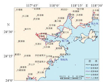
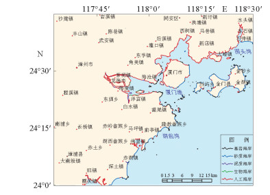
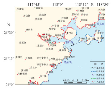
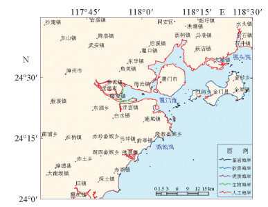
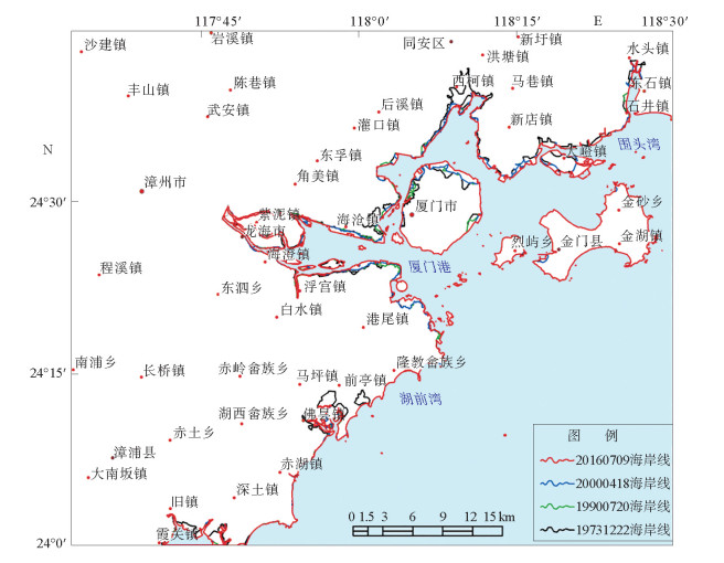
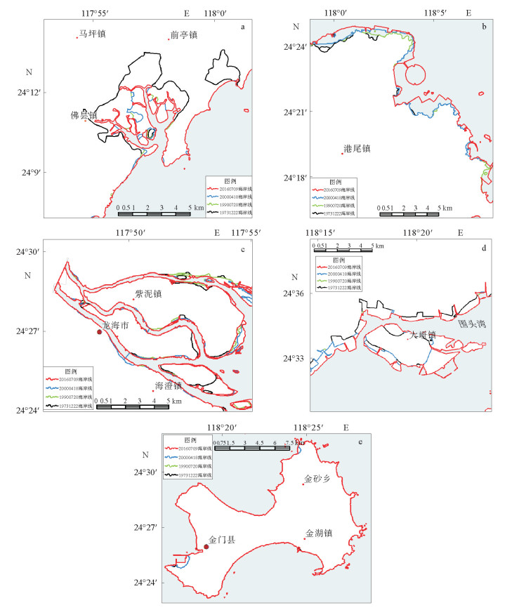
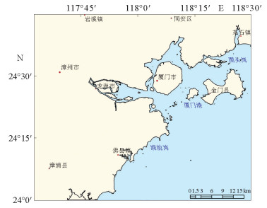
以厦门及其邻域1973、1990、2000年以及2016年共4期MSS、TM、ETM和OLI遥感影像数据,结合地形数据,构建了厦门及其邻域海岸线分类方案和解译规则,利用人机交互方法解译研究区4时相的海岸线。分析了近40 a来该区域的海岸线变迁特征,结果表明:1973—2016年,岸线总体呈增长趋势,总长度从759 376 m增加到885 433 m,1973—1990年增长0.94%,1990—2000年增长6.29%,2000—2016年增长8.67%,其中人工海岸线长度增长最为突出;研究区岸线变化北部明显多于南部;海岸线外扩主要集中在北部石井镇至隆教畲族一线和厦门岛,九龙江湾在1990—2016年的岸线变迁亦十分突出,而金门岛岸线自1973年起变化微弱;人类社会经济活动是岸线变迁的主要原因,人类对沿海用地需求大,围海造地成为人工海岸持续增长的动力。
Abstract:Based on the MSS, TM, ETM and OLI remote sensing image data collected in 1973, 1990, 2000 and 2016, respectively, as well as the topographic data available, we made a detailed study on the coastline changes in Xiamen and surrounding areas. A coastline classification and interpretation guidelines are established, and a 4-phase coastline system of the research area was recognized with human-computer interaction method. At last, the characteristics of coastline change in this area for the past 40 years are proposed as the results. The results show that from 1973 to 2016, the coastline of the study area was generally under an increasing trend, and the total length increased from 759 376 m to 885 433 m. The growth rate was 0.94% from 1973 to 1990, 6.29% from 1990 to 2000, and 8.67% from 2000 to 2016, in which the growth of artificial coastline dominates; The coastline increment in the north of the study area is significantly higher than that in the south during the past 40 years, in particular, in the north of Shijing Town, the Longjiao and the Xiamen Island.The coastline change around Jiulongjiang Bay is also very prominent in the period of 1990-2016. However, the coast around the Jinmen Island has remained stable since 1973. With the increase in demand for coastal land, human activities, especially land reclamation, has become the driving force for the sustained growth of artificial coastline in the region.
-
Key words:
- coastline changes /
- artificial coastline /
- cofferdam /
- remote sensing /
- Xiamen
-

-
表 1 遥感数据表
Table 1. List of remote sensing data used
年份 传感器类型 采集时间 分辨率/m 1973 MSS 1973-12-22 30 1990 TM 1990-07-02 30 2000 ETM 2000-04-18 30 2016 OLI 2016-07-09 30  下载: 导出CSV
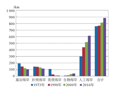
表 2 岸线变化长度统计表
Table 2. List of changes in coastline
时相 1973年海岸线 1990年海岸线 2000年海岸线 2016年海岸线 海岸线类型 条段 长度/m 条段 长度/m 条段 长度/m 条段 长度/m 基岩海岸 314 195 776 260 147 473 219 122 173 190 106 718 砂质海岸 203 145 596 197 142 549 180 132 170 157 114 902 泥质海岸 120 107 477 45 25 935 21 10 533 13 9 584 生物海岸 9 8 061 14 10 823 35 31 489 31 41 037 人工海岸 228 302 466 259 439 765 287 518 391 225 613 192 合计 759 376 766 545 814 756 885 433
下载: 导出CSV
-
[1] 李静, 张鹰, Li J, 等.基于遥感测量的海岸线变化与分析[J].河海大学学报(自然科学版), 2012, 40(2):224-228. doi: 10.3876/j.issn.1000-1980.2012.02.019
[2] 李刚, 万荣胜, 陈泓君, 等.海南岛南部海岸线变迁及其成因[J].海洋地质前沿, 2018, 34(1):48-54. http://hydt.cbpt.cnki.net/WKA/WebPublication/paperDigest.aspx?paperID=f7e6f588-34de-4807-bab0-17aff9003ebe
[3] 李梅娜, 陈小英, 刘金庆, 等.基于遥感的威海岸线变迁分析[J].海洋地质与第四纪地质, 2016, 36(6):79-84. http://www.wanfangdata.com.cn/details/detail.do?_type=perio&id=hydzydsjdz201606010
[4] 于杰, 杜飞雁, 陈国宝, 等.基于遥感技术的大亚湾海岸线的变迁研究[J].遥感技术与应用, 2009, 24(4):512-516. http://d.old.wanfangdata.com.cn/Periodical/ygjsyyy200904015
[5] 朱俊凤, 王耿明, 张金兰, 等.珠江三角洲海岸线遥感调查和近期演变分析[J].国土资源遥感, 2013, 25(3):13-137. http://d.old.wanfangdata.com.cn/Periodical/gtzyyg201303022
[6] 杨磊, 李加林, 袁麒翔, 等.中国南方大陆海岸线时空变迁[J].海洋学研究, 2014, 32(3):42-49. doi: 10.3969/j.issn.1001-909X.2014.03.006
[7] Chen L C, Rau J Y.Detection of shoreline changes for tideland area using multi-temporal satellite images[J].International Journal of Remote Sensing, 1998, 19(17):3383-3397. doi: 10.1080/014311698214055
[8] Chu Z X, Yang X H, Feng X L, et al.Temporal and spatial changes in coastline movement of the Yangtze delta during 1974-2010[J].Journal of Asian Earth Sciences, 2013, 66:166-174. doi: 10.1016/j.jseaes.2013.01.002
[9] 吴丹丹, 葛晨东, 许鑫王豪, 等.厦门海岸工程对岸线变迁及海洋环境的影响研究[J].环境科学与管理, 2011, 36(10):67-83. doi: 10.3969/j.issn.1673-1212.2011.10.017
[10] 庄翠蓉.厦门海岸线遥感动态监测研究[J].海洋地质动态, 2009, 25(4):13-17. doi: 10.3969/j.issn.1009-2722.2009.04.003
[11] 王琳.厦门岛及其邻域海岸线变化的遥感动态监测[J].遥感技术与应用, 2005, 20(4):404-410. doi: 10.3969/j.issn.1004-0323.2005.04.005
[12] 李亮, 田福金, 郭建明.近30年福建省海岸线变迁遥感解译分析[J].地质论评, 2017, 63(增刊):360-362. http://www.wanfangdata.com.cn/details/detail.do?_type=perio&id=9146493
[13] 翁宇斌, 罗美雪, 任岳森.福建省海岛岸线修测及其意义[J].海洋开发与管理, 2011(5):45-50. doi: 10.3969/j.issn.1005-9857.2011.05.010
[14] 刘荣杰, 张杰, 闫秋双, 等.1982—2012年间福建省主要河口海岸岸线变迁遥感监测分析[J].应用海洋学学报, 2014, 33(3):425-433. doi: 10.3969/J.ISSN.2095-4972.2014.03.019
[15] 李萌萌, 张彩云, 林锐.基于遥感技术的厦门大嶝岛海岸线与潮滩变迁分析[J].厦门大学学报(自然科学版), 2018, 57(1):85-91. http://d.old.wanfangdata.com.cn/Periodical/xmdxxb201801013
[16] 马瑞芳, 陈芳, 祝幼华, 等.台湾海峡中北部陆架区表层沉积的近代沟鞭藻囊孢组合及其环境意义[J].古生物学报, 2014, 53(1):92-100. http://www.wanfangdata.com.cn/details/detail.do?_type=perio&id=gswxb201401008
[17] 王学平.遥感图像几何校正原理及效果分析[J].计算机应用与软件, 2008, 25(9):102-105. doi: 10.3969/j.issn.1000-386X.2008.09.038
[18] 国家海洋局908专项办公室.我国近海海洋综合调查与评价专项海岸线修测技术规程:试行本[M].北京:海洋出版社, 2007.
[19] 索安宁, 曹可, 马红伟, 等.海岸线分类体系探讨[J].地球科学, 2015, 35(7):933-937. http://www.wanfangdata.com.cn/details/detail.do?_type=perio&id=dlkx201507018
-
图(9)
表(2)
计量
- 文章访问数: 1139
- PDF下载数: 63
- 施引文献: 0